Hello,
Its been quite a while since i've been on these forums but I quite often look into the conditions in your part of the world with some interest (particularly growing at the moment as I consider whether to move down to your fascinating country on a working holiday scheme)
I thought i'd take a look to see what the effects of sudden stratospheric warnings in the southern hemisphere were, but I was amazed to see (there is every chance I have missed it!) that it wasn't being discussed down here.
For anyone who hasn't any idea what I'm talking about heres a brief summary. The reason for the usual west-east flow at mid lattitudes (both northern hemisphere and southern) is all to do with the polar vortex. The polar vortex is the series of intense low pressure systems that set up shop over the antarctic (and arctic), and tend to prevent too much meridonality (S-N or N-S) developing within the flow. Instead you have what is called a zonal flow (dominant W - E movement of systems). Whilst there are exceptions to this rule, generally speaking you need some sort of blocking patterns to set up over the antarctic regions to allow a more meridonal flow to develop across the entirety of the longwave pattern around the southern hemisphere.
And just as a quick heads up - the stratosphere is the second (or third depending on how you classify it) layer of the atmosphere up from the surface. The bit that we live in is called the troposphere, and exists from the surface up to roughly 17km across the mid lattitudes. You then have the tropopause, which is the very thin intersection between the troposphere, and the stratosphere. The stratosphere is the layer above this, and can stretch anything up to 50km above the surface of the earth. Its worth remembering that the height of these layers vary. The stratosphere exists at a pressure altitude of roughly 200mB all the way up to 1mB (or hPa, if you prefer), though for the purposes of this we tend to look at the 100-1mB range, with 30mB being the most prominently monitored layer.
The polar vortex is governed in strength by the thermal gradient (the difference in temperature) between the stratosphere above the polar regions and those above the equator. Now obviously just as at the surface, the stratosphere above the equator is warmer than that above the polar regions, and so this natural difference in temperature (the thermal gradient) is what usually leads to the development of a strong polar vortex in the stratosphere, which usually sees the pattern downwell all the way to the troposphere.
So the reason we are so interested in seeing episodes of warming in the polar stratosphere is to reduce the thermal gradient by bringing the temperature of the polar stratosphere closer to that of the tropical stratosphere and, thereby, leading to the reduction in strength of the polar vortex and increasing the chances of the development of blocking highs which, depending on where your particular location ends up within the longwave pattern, leads to an increase in the likelihood of polar air flooding from the higher to mid latitudes.
For some reason, however, these episodes of warming seem to be far more frequent in the northern hemisphere than in the south. In fact the stratospheric forecast is one of the most sought after this coming winter in the weather community in the UK, particularly given the news that the UK Met Office have just started using it in their own longer range forecasting methodology. In fact if you want to learn more about it from a northern hemisphere point of view I would strongly recommend reading the ever growing thread about it over on the netweather forum (linked to I believe in the international links section on this forum), where there are people far more knowledgeable than me on the subject giving a pretty comprehensive overview of all the factors surrounding this phenomenon.
So it is far more rare to see such a setup occuring in the southern hemisphere for reasons which, as far as I know, appear presently to be unknown. I have my own theories on this, given that generally these warming episodes tend to be partially o-zone driven, and given the hole in the southern hemisphere, this would explain perhaps why there have been fewer here. That is far from scientific proof though I accept.
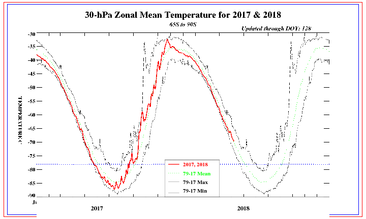
The only major recorded warming in the southern hemisphere was back in 2002 (bearing in mind records only go back as far as 1979 for this)...that was until this past week.
We have been watching with interest in the north as the southern hemisphere has had a record breaking stratospheric warming episode:
http://www.cpc.ncep.noaa.gov/products/s ... mb6590.gif
That is just at the 30mB level....it is just as significant throughout the layers, as can be seen here:
http://www.cpc.ncep.noaa.gov/products/s ... mb6590.gif
Now, being somebody who has followed northern hemisphere patterns for so long I am unsure of the exact effects that this may have in the southern hemisphere, but its something that should be watched with great excitement down there. Generally speaking there is a 2-3 week time lag with these warming episodes before they take effect on conditions at the surface, so you may well find that within the 15-20 day time period there could be some pretty substantial blocking appear over the antarctic, flooding some cold air down in towards your latitudes.
In order for a warming event to be classified as a 'sudden stratospheric warming (SSW), the zonal winds at 60S have to be reversed (IE switch from westerly to easterly). Now whilst this is more significant for us in the UK given that the usual flow (from the west) comes from the warmer atlantic ocean, where as an easterly flow comes from the (usually) very cold continent, it can still be of significance for you guys. So whilst an easterly would not be especially cold for you normally, obviously if blocking highs do set up and displace cold air from the antarctic to mid latitudes, then there is a much higher chance of you guys tapping into this cold air.
The biggest influence though is likely to be an increase in tendency for high pressure and, therefore, suppressed rainfall totals.
So its well worth keeping an eye on as its a very rare event down there, and its something I will be watching closely
All the best,
Kris
Record SSW Event
Forum rules
These topics are a read-only archive and may be subject to out-of-date information.
For today's weather discussion head to: New Zealand Weather & Climate
These topics are a read-only archive and may be subject to out-of-date information.
For today's weather discussion head to: New Zealand Weather & Climate