Sub-tropic low affecting North Island, July 3-8th
Forum rules
These topics are a read-only archive and may be subject to out-of-date information.
For today's weather discussion head to: New Zealand Weather & Climate
These topics are a read-only archive and may be subject to out-of-date information.
For today's weather discussion head to: New Zealand Weather & Climate
-
Razor
- Moderator
- Posts: 5138
- Joined: Fri 10/02/2006 15:14
- Location: Halswell, Christchurch
- Has thanked: 725 times
- Been thanked: 932 times
Re: Unsettled Early July
I think this thread should be renamed to focus on the North Island. South Island weather looks reasonably settled for a while now by comparison.
Christchurch Rocks
-
Michael

- Posts: 7210
- Joined: Thu 27/03/2003 12:04
- Location: Rainy Manurewa, Auckland - "City of Gales"
- Has thanked: 0
- Been thanked: 1 time
- Contact:
Re: Unsettled Early July- North Island
ECWMF has it dragged up the eastcoast of the SI this time next week from a secondary low including the NI low then to the chathams in the tasman with an intense anticyclone in the south tasman.
-
David

- Posts: 7587
- Joined: Sat 18/08/2007 21:02
- Location: Howick, Auckland
- Has thanked: 418 times
- Been thanked: 832 times
- Contact:
Re: Unsettled Early July- North Island
Sure looks increasingly likely that we are going to get a very strong easterly here on Sunday night....12Z GFS tells me mean wind will reach E 59km/h
-
Michael
- Posts: 7210
- Joined: Thu 27/03/2003 12:04
- Location: Rainy Manurewa, Auckland - "City of Gales"
- Has thanked: 0
- Been thanked: 1 time
- Contact:
Re: Sub-tropic low affecting North Island, July 3-8th
doesnt look much there yet,just a trough,maybe it will appear over the next 24 hours.
-
NZstorm

- Posts: 11333
- Joined: Mon 10/03/2003 19:38
- Location: Grey Lynn, Auckland
- Has thanked: 342 times
- Been thanked: 361 times
Re: Sub-tropic low affecting North Island, July 3-8th
Theres a big jet stream through the North Tasman which will lead to the low development in the next 24hrs.just a trough,maybe it will appear over the next 24 hours.
Yes, we may get to gale force in Auckland overnight Sunday. Gales more possible over North Auckland region though.Sure looks increasingly likely that we are going to get a very strong easterly here on Sunday night.
-
David
- Posts: 7587
- Joined: Sat 18/08/2007 21:02
- Location: Howick, Auckland
- Has thanked: 418 times
- Been thanked: 832 times
- Contact:
Re: Sub-tropic low affecting North Island, July 3-8th
Severe Weather Warning issued:
Severe Weather Watch issued:ISSUED BY MetService AT
10:34 am 03-Jul-2010
MEDIA
Heavy rain expected on Sunday for Northland, Coromandel Peninsula and western Bay of Plenty.
A low is deepening over the north Tasman Sea. Its associated front is expected to move over Northland on Sunday preceded by northeast gales and a period of heavy rain. Around 80mm of rain is possible over parts of Northland in about 9 hours tomorrow and over the Coromandel Peninsula and western Bay of Plenty overnight from Sunday to Monday.
People in these areas are advised to watch out for rapidly rising to streams and rivers and hazardous driving conditions.
http://metservice.com/national/warnings ... r-warnings
Interesting they say NE gales. The models show the winds to be E tending SE eventually.SEVERE WEATHER WATCH FOR NORTHLAND AUCKLAND WAIKATO COROMANDEL
PENINSULA
ISSUED BY METSERVICE AT 1034hrs 03-Jul-2010
A low is deepening over the north Tasman Sea. Its associated front is
expected to move over Northland on Sunday preceded by northeast gales
and heavy rain. A heavy rainfall warning is in force for parts of
Northland, Coromandel Peninsula and western Bay of Plenty.
Wind gusts of 100km/h are expected to develop ahead of the front over
Northland Sunday morning, spreading to Auckland and Coromandel
Peninsula in the afternoon and to Waikato in the lee of the Kaimai
Ranges in the evening or at night. It is possible the wind gusts will
be stronger and a watch is in force these areas for gusts 120km/h or
greater.
This Watch will be reviewed by 11am Sunday 4 July
Forecast prepared by: Erick Brenstrum
http://metservice.com/national/warnings ... ther-watch
-
Michael
- Posts: 7210
- Joined: Thu 27/03/2003 12:04
- Location: Rainy Manurewa, Auckland - "City of Gales"
- Has thanked: 0
- Been thanked: 1 time
- Contact:
Re: Sub-tropic low affecting North Island, July 3-8th
1000 time BOM shows trough as 1015hpa,990 tomorrow,must be 1/2 a weather bomb according to BOM no pun intended 
needs 21 hpa??? to qualify
needs 21 hpa??? to qualify
You do not have the required permissions to view the files attached to this post.
-
spwill
- Posts: 9920
- Joined: Sun 29/06/2003 22:39
- Location: Mt Eden Auckland
- Has thanked: 856 times
- Been thanked: 870 times
Re: Sub-tropic low affecting North Island, July 3-8th
I noticed a big cruise ship in Auckland today, I think it leaves for Brisbane tonight.
-
David
- Posts: 7587
- Joined: Sat 18/08/2007 21:02
- Location: Howick, Auckland
- Has thanked: 418 times
- Been thanked: 832 times
- Contact:
Re: Sub-tropic low affecting North Island, July 3-8th
I can't understand why MS are saying NE for Auckland, all their models show an easterly 
-
NZ Thunderstorm Soc
- Posts: 18491
- Joined: Wed 12/03/2003 22:08
- Location: Raukapuka Geraldine
- Has thanked: 1769 times
- Been thanked: 1415 times
Re: Sub-tropic low affecting North Island, July 3-8th
....depends where it comes from. If From Brisbane could be a BOMB bombMichael wrote:a weather bomb according to BOM no pun intended
JohnGaul
NZThS
JohnGaul
NZThS
NZThS
-
Michael
- Posts: 7210
- Joined: Thu 27/03/2003 12:04
- Location: Rainy Manurewa, Auckland - "City of Gales"
- Has thanked: 0
- Been thanked: 1 time
- Contact:
Re: Sub-tropic low affecting North Island, July 3-8th
Wednesdays looking quite suck at this time,on the entire metservice map,Auckland and one other area just NE of the hauraki gulf has 3&1/2 windroses even the southern ocean dont achieve it,hopefully it just doesnt move parallel down the eastcoast.
-
NZstorm
- Posts: 11333
- Joined: Mon 10/03/2003 19:38
- Location: Grey Lynn, Auckland
- Has thanked: 342 times
- Been thanked: 361 times
Re: Sub-tropic low affecting North Island, July 3-8th
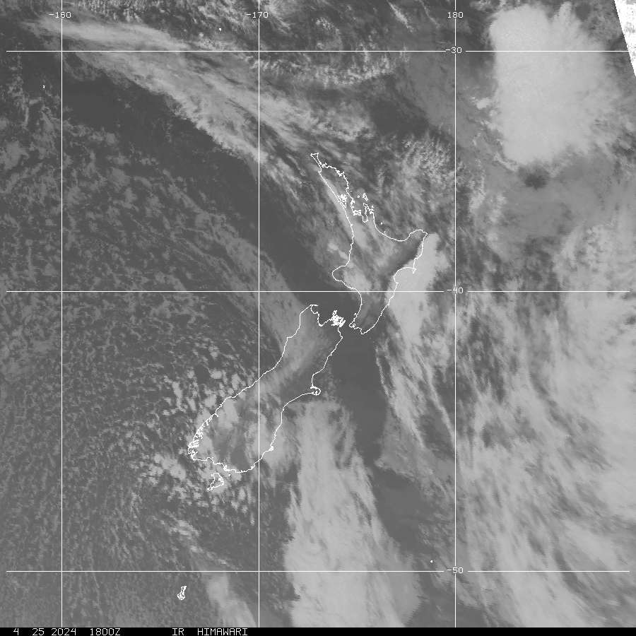
Is that two low pressure centres showing up in the satellite pic in the north Tasman currently. Also some elevated convection developing over the top of Northland.
GFS still indicating the Gisborne/Hawkes Bay regions will take the biggest rainfall hit. The Coromandel EW rain gauges could be interesting viewing also!
GFS still indicating the Gisborne/Hawkes Bay regions will take the biggest rainfall hit. The Coromandel EW rain gauges could be interesting viewing also!
-
Michael
- Posts: 7210
- Joined: Thu 27/03/2003 12:04
- Location: Rainy Manurewa, Auckland - "City of Gales"
- Has thanked: 0
- Been thanked: 1 time
- Contact:
Re: Sub-tropic low affecting North Island, July 3-8th
Strange these days we never get our rain from the NE plus the NE wind we used to get with it.
-
Tornado Tim

- Moderator
- Posts: 4920
- Joined: Sun 19/10/2008 17:17
- Location: Raglan, Waikato / Hillcrest, Hamilton
- Has thanked: 102 times
- Been thanked: 202 times
- Contact:
Re: Sub-tropic low affecting North Island, July 3-8th
Fogged in again 
The Front over Northland looks good atm but it seems its dying
The Front over Northland looks good atm but it seems its dying
NZAPStrike.net - NZ Aus Pacific Strike Network
-
David
- Posts: 7587
- Joined: Sat 18/08/2007 21:02
- Location: Howick, Auckland
- Has thanked: 418 times
- Been thanked: 832 times
- Contact:
Re: Sub-tropic low affecting North Island, July 3-8th
It's like the calm before the storm....only gusting to 15km/h so far
-
CHCH Weather Chaser

- Posts: 3460
- Joined: Thu 26/06/2008 16:10
- Location: Halswell / Hoon Hay Christchurch
- Has thanked: 0
- Been thanked: 0
Re: Sub-tropic low affecting North Island, July 3-8th
Looks like it is going to be awful conditions for the warriors match in Auckland this afternoon. The commentators said last week here at AMI Stadium that " here in the rain, mist and sleet". Ah commentators it was like 8 degrees still and a typical drizzle that the city has  Anyways maybe might get to watch some heavy rain in Auckland on TV later
Reporting Live from Southern Christchurch
Leighton Thomas
2014 Rainfall: Jan: 21mm Feb: 76mm March: 170mm April: 201mm YTD: 468mm
Leighton Thomas
2014 Rainfall: Jan: 21mm Feb: 76mm March: 170mm April: 201mm YTD: 468mm
-
spwill
- Posts: 9920
- Joined: Sun 29/06/2003 22:39
- Location: Mt Eden Auckland
- Has thanked: 856 times
- Been thanked: 870 times
Re: Sub-tropic low affecting North Island, July 3-8th
Not too bad currently, cloud cover but bright and a few rain spots,light winds,feels cold or atleast cold for us 11C.Looks like it is going to be awful conditions for the warriors match in Auckland this afternoon.
-
Nev

- Moderator
- Posts: 6231
- Joined: Tue 07/03/2006 15:24
- Location: Waiheke Island, Hauraki Gulf
- Has thanked: 474 times
- Been thanked: 1073 times
Re: Sub-tropic low affecting North Island, July 3-8th
^11C? More like about 13C here and most other places around Ak at midday, including the airport.
Strong E'erlys out in the Gulf atm.
Not too often you see warnings in force for the Hauraki Gulf of E'erly and SE winds to 40 knots for this evening and tomorrow morn, albeit N of Whangaparaoa, with gusts to 50 knots for both of Akld's Harbours.
Our low's become pretty well organised today...
Strong E'erlys out in the Gulf atm.
Not too often you see warnings in force for the Hauraki Gulf of E'erly and SE winds to 40 knots for this evening and tomorrow morn, albeit N of Whangaparaoa, with gusts to 50 knots for both of Akld's Harbours.
Our low's become pretty well organised today...
You do not have the required permissions to view the files attached to this post.
-
Philip Duncan
- Posts: 519
- Joined: Mon 27/08/2007 21:02
- Location: Waitakere City
- Has thanked: 0
- Been thanked: 0
- Contact:
Re: Sub-tropic low affecting North Island, July 3-8th
Yep I think some those ranges could see 400mm over this entire event... if that happens that could cause significant flooding.NZstorm wrote:
GFS still indicating the Gisborne/Hawkes Bay regions will take the biggest rainfall hit. The Coromandel EW rain gauges could be interesting viewing also!
-
David
- Posts: 7587
- Joined: Sat 18/08/2007 21:02
- Location: Howick, Auckland
- Has thanked: 418 times
- Been thanked: 832 times
- Contact:
Re: Sub-tropic low affecting North Island, July 3-8th
Still got a light breeze here, sure is taking its time moving down...
-
igaquo1

- Posts: 61
- Joined: Sun 17/08/2008 10:51
- Location: Papamoa Beach, Bay of Plenty / London
- Has thanked: 3 times
- Been thanked: 2 times
Re: Sub-tropic low affecting North Island, July 3-8th
Sorry if asked before, but where did you get that sat pic from? thanks
____________________________________________________________________________________________
Jeremy B
Kiwi from Auckland, living in London and watching NZ weather from afar. Occasionally back in Auckland and Tauranga.
Jeremy B
Kiwi from Auckland, living in London and watching NZ weather from afar. Occasionally back in Auckland and Tauranga.
-
DT-NZ

- Posts: 1010
- Joined: Mon 09/02/2009 10:55
- Location: Northland, NZ
- Has thanked: 0
- Been thanked: 0
Re: Sub-tropic low affecting North Island, July 3-8th
Report from Hukerenui, strong gusty NE winds arrived here approx 20 mins ago, moderate to heavy rainfall, now only light drizzle out at moment - clouds are moving fast up there.
Did try to do a report earlier on this afternoon, however, everything is running slow on the internet - seems to be running faster now.
Did try to do a report earlier on this afternoon, however, everything is running slow on the internet - seems to be running faster now.
Lightning in NZ
The right terminology lends a hint as to the nature of the different forms.
A Vertigo Quote.
The right terminology lends a hint as to the nature of the different forms.
A Vertigo Quote.
-
David
- Posts: 7587
- Joined: Sat 18/08/2007 21:02
- Location: Howick, Auckland
- Has thanked: 418 times
- Been thanked: 832 times
- Contact:
Re: Sub-tropic low affecting North Island, July 3-8th
Almost 5pm and still barely any wind - and to think I was expecting to break my record high gust today (61km/h) 
-
Nev
- Moderator
- Posts: 6231
- Joined: Tue 07/03/2006 15:24
- Location: Waiheke Island, Hauraki Gulf
- Has thanked: 474 times
- Been thanked: 1073 times
Re: Sub-tropic low affecting North Island, July 3-8th
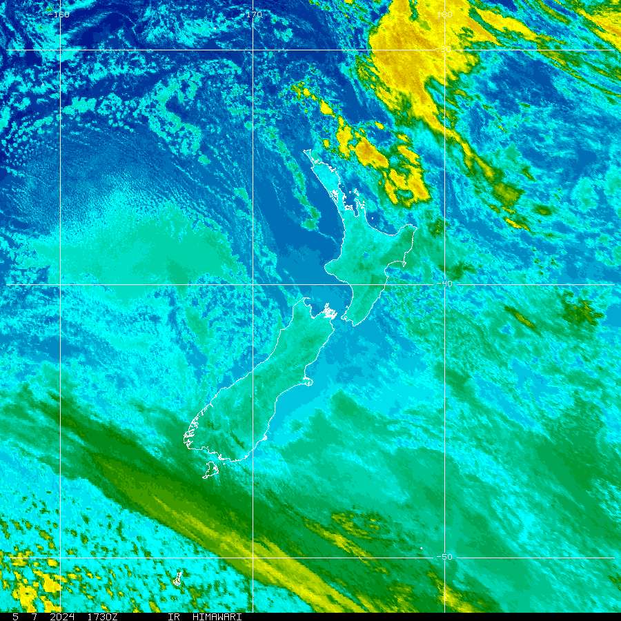
NOAA/MTSAT Geostationary Satelliteigaquo1 wrote:Sorry if asked before, but where did you get that sat pic from? thanks
(images updated approx 30 minutes past the hour)
Visible (daytime only)
Visible/IR Combined
-
Nev
- Moderator
- Posts: 6231
- Joined: Tue 07/03/2006 15:24
- Location: Waiheke Island, Hauraki Gulf
- Has thanked: 474 times
- Been thanked: 1073 times
Re: Sub-tropic low affecting North Island, July 3-8th
Sounds like you must in the lee the Coromandel/greater-landmass where you are David?David wrote:Almost 5pm and still barely any wind - and to think I was expecting to break my record high gust today (61km/h)
Mean E'erly winds of at least 52 km/h on the Waitemata and 74 km/h out at Tiritiri Lighthouse.
5mm of light rain here so this arvo. I see KerikeriWeather has had 47mm today.
P.S. That 13C around noon was fairly short-lived - back down to about 11C here now.