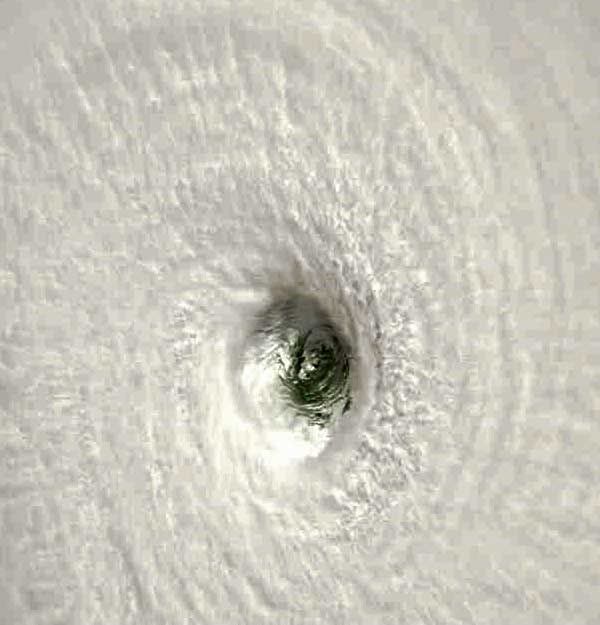
Tropical Cyclone Monica

Discussion of weather and climate outside of NZ's waters. Australian weather, tropical cyclones and USA storm chasing feature here.
Manukau heads obs
Posts: 12305
Joined: Mon 10/03/2003 16:30
Location: West Coast Road, Manukau Peninsula, North Island

Unread post by Manukau heads obs »

wow, what an amazing picture!!
Image
Brian Hamilton, weather enthusiast. My weather dataEmail: [email protected]
NZ Thunderstorm Soc
Posts: 19109
Joined: Wed 12/03/2003 22:08
Location: Raukapuka Geraldine

Unread post by NZ Thunderstorm Soc »

Foggy Hamilton wrote:Her eye this morning NZST 12.55am
Image

Record setter she is :shock:

Looks like a belly button :D

JohnGaul
NZTS
User avatar
Storm Struck
Posts: 5057
Joined: Wed 17/11/2004 21:25
Location: Belfast Christchurch

Unread post by Storm Struck »

170-190kts at times now :shock: thats what 370kmh :? :shock: they saying its the biggest in the southern hemisphere id think now it would be biggest storm on earth since weather data records began hundreds years ago. 8)
Cheers
Jason.
Canterbury, home of good rugby and severe storms
spwill
Posts: 10200
Joined: Sun 29/06/2003 22:39
Location: Mt Eden Auckland

Unread post by spwill »

they saying its the biggest in the southern hemisphere id think now it would be biggest storm on earth since weather data records began hundreds years ago.
Yes but the only thing MonEca will blow over is wild gum trees unlike Southern USA where you have many major populated area's.
Manukau heads obs
Posts: 12305
Joined: Mon 10/03/2003 16:30
Location: West Coast Road, Manukau Peninsula, North Island

Unread post by Manukau heads obs »

it has move more SW and has now come ashore...and lost its eye....
darwin will still get a battering, but it might even go to the south of darwin?
Image
Brian Hamilton, weather enthusiast. My weather dataEmail: [email protected]
Manukau heads obs
Posts: 12305
Joined: Mon 10/03/2003 16:30
Location: West Coast Road, Manukau Peninsula, North Island

Unread post by Manukau heads obs »

its moving more SSW and more inland and weakening all the time...Darwin is spared
Image
Brian Hamilton, weather enthusiast. My weather dataEmail: [email protected]
squid
Posts: 1304
Joined: Thu 16/06/2005 13:57
Location: Caboolture,QLD

Unread post by squid »

well darwin should only get a period of gales at the worst now boy she was the most strongest storm that i have ever seen dovork system had her at 868 at her peak what a storm the forcast mpas still says for a WSW movement and possible strengthening again then she gets back over water will beeintetrestig to see if the trough takes her south or of she gets on the next ridge and moves W or even WNW again
squid
Posts: 1304
Joined: Thu 16/06/2005 13:57
Location: Caboolture,QLD

Unread post by squid »

monica died but she is coming back it is amazing to watch on radar her regenerating
Andrew Massie
Posts: 1032
Joined: Fri 10/03/2006 14:03

Unread post by Andrew Massie »

squid wrote:monica died but she is coming back it is amazing to watch on radar her regenerating
Yeah, I bumped into a woman at a funeral today, she was telling me all about her amazing son teaching aborigines in Alice Springs. I said "he'll get some rain soon", she LAUGHED at me and made a joke about that being ridiculous...... Monica's getting close to it...
squid
Posts: 1304
Joined: Thu 16/06/2005 13:57
Location: Caboolture,QLD

Unread post by squid »

well monica tryed but failed to regenerate her remains dumped some good falls of rain across the NT and QLD and NSW