you should start to see some buildups happening about lunchtime and then wait for the afternoon deluge.
i think the problem we had yesterday was a lack of moisture, if we can get more of that today then we could be in.
Low #3, yet more Thunderstorms
Forum rules
These topics are a read-only archive and may be subject to out-of-date information.
For today's weather discussion head to: New Zealand Weather & Climate
These topics are a read-only archive and may be subject to out-of-date information.
For today's weather discussion head to: New Zealand Weather & Climate
-
spwill
- Posts: 10200
- Joined: Sun 29/06/2003 22:39
- Location: Mt Eden Auckland
-
Razor
- Moderator
- Posts: 5492
- Joined: Fri 10/02/2006 15:14
- Location: Halswell, Christchurch
-
C-Nimbus
- Posts: 692
- Joined: Tue 20/01/2004 13:22
- Location: Waitakere City - Westie!!
-
Willoughby

- Site Admin
- Posts: 4443
- Joined: Sat 14/06/2003 16:18
- Location: Darwin, Australia: Storm city
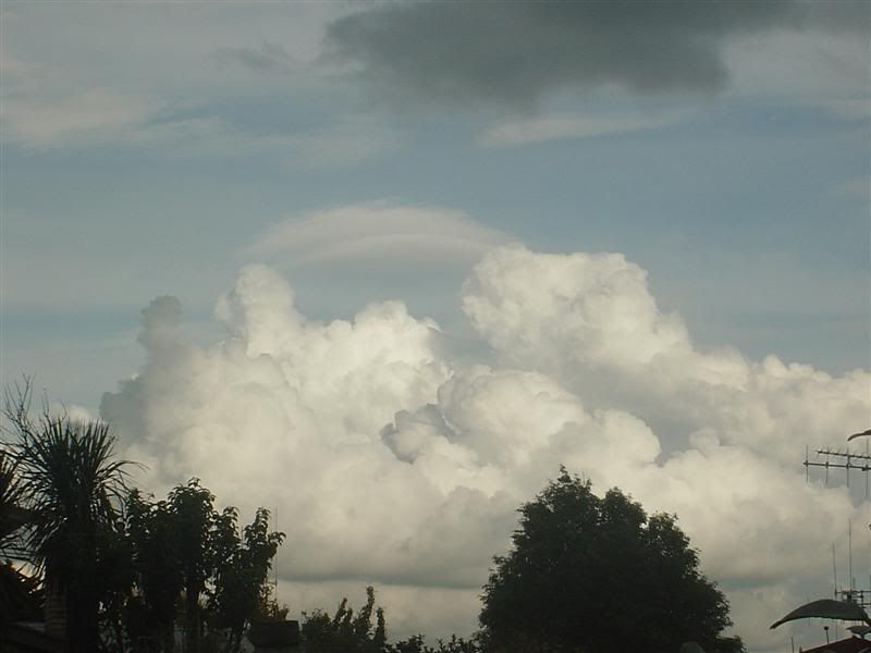
A cool foggy, but now hazy day here. The cumulus are growing solidly thanks to the added moisture.
Some nice Cb's out there west of Northland but this warm front is highly unorganised so I wonder how much rain will be widespread tonight.
Storm steer is northerly, and shear looks good. Thunderstorms may again be running into the East Auckland suburbs later tonight.
Note the work 'risk' Razor
Some nice Cb's out there west of Northland but this warm front is highly unorganised so I wonder how much rain will be widespread tonight.
Storm steer is northerly, and shear looks good. Thunderstorms may again be running into the East Auckland suburbs later tonight.
Note the work 'risk' Razor
-
Razor
- Moderator
- Posts: 5492
- Joined: Fri 10/02/2006 15:14
- Location: Halswell, Christchurch
Its no wonder the average person on the street gets so sceptical about the metservice and the like. The amount of times "thunderstorms" have been mentioned in the forecasts for days which have not eventuated is quite large this year.
Perhaps the method of delivering weather forecasts to the populace needs to be reviewed, so there is a better understanding of the uncertainties of 'risk'.
Perhaps the method of delivering weather forecasts to the populace needs to be reviewed, so there is a better understanding of the uncertainties of 'risk'.
Christchurch Rocks
-
Manukau heads obs
- Posts: 12305
- Joined: Mon 10/03/2003 16:30
- Location: West Coast Road, Manukau Peninsula, North Island
you have to be within 10km(?) or less of a lightning strike to be able to hear it inside a building
so even if there was a thunderstorm where it was forecasted, only people in a certain radius from that thunderstorm would even know there was thunder and lightning
there are thunderstorms around today, you can see them on the lightning tracker and on the sat image
they are moving down on the bay of islands at the moment, and they are out to the west of the NI at the moment too
and they are moving towards the greater auckland area

-
Willoughby
- Site Admin
- Posts: 4443
- Joined: Sat 14/06/2003 16:18
- Location: Darwin, Australia: Storm city
-
spwill
- Posts: 10200
- Joined: Sun 29/06/2003 22:39
- Location: Mt Eden Auckland
Have had some towering Cu around Auckland today as well.
Current location of TS to our NW.
http://flash.ess.washington.edu/L_plot_weather_map.jpg
Current location of TS to our NW.
http://flash.ess.washington.edu/L_plot_weather_map.jpg
-
Willoughby
- Site Admin
- Posts: 4443
- Joined: Sat 14/06/2003 16:18
- Location: Darwin, Australia: Storm city
Just came into rain radar zone.. it's lookin good for western areas!spwill wrote: Current location of TS to our NW.
http://flash.ess.washington.edu/L_plot_weather_map.jpg
-
spwill
- Posts: 10200
- Joined: Sun 29/06/2003 22:39
- Location: Mt Eden Auckland
-
NZ Thunderstorm Soc
- Posts: 19110
- Joined: Wed 12/03/2003 22:08
- Location: Raukapuka Geraldine
-
03Stormchaser

- Moderator
- Posts: 4433
- Joined: Tue 09/12/2003 12:11
- Location: Prebbleton
Was interesting, had a decent heavyish shower come thru around 12.15pm. My home rain gauge didnt record anything other than a few spits, and I like a mere 2 minutes away!! So was very localised.NZ Thunderstorm Soc wrote:Interesting skies around Christchurch today but nothing much to photograph.
Looking really heavy especially in the afternoon when the weak convergence when through around 12:30pm.
Not much wind.
JohnGaul
NZTS
NZ Largest Storm Chasing Facebook Pagehttp://www.facebook.com/nzstormchasers
NZ Largest Storm Chase Community https://www.facebook.com/groups/NZStormchasersGroup
NZ Stormchasers TV https://www.youtube.com/@NZStormchasers
NZ Largest Storm Chase Community https://www.facebook.com/groups/NZStormchasersGroup
NZ Stormchasers TV https://www.youtube.com/@NZStormchasers
-
Cameo1
- Posts: 417
- Joined: Mon 24/04/2006 19:32
- Location: New Lynn West, Auckland
-
NZstorm

- Posts: 11333
- Joined: Mon 10/03/2003 19:38
- Location: Grey Lynn, Auckland
-
ricky
- Posts: 1056
- Joined: Sun 28/09/2003 21:27
- Location: Grey Lynn, Auckland

-
uretiti
- Posts: 16
- Joined: Mon 13/02/2006 15:20
- Location: Waipu, Northland
Update from the North
Just to let you know, it rained reasonably heavy here at around 5.30ish then just light showers, but then lots of lightning out to the east of us, and now (nearly 9pm) is raining quite heavy, not sure which way its going seems to be all over the place !!
will let u all know if it starts getting exciting..........
will let u all know if it starts getting exciting..........
-
Cameo1
- Posts: 417
- Joined: Mon 24/04/2006 19:32
- Location: New Lynn West, Auckland
-
Cameo1
- Posts: 417
- Joined: Mon 24/04/2006 19:32
- Location: New Lynn West, Auckland
-
Cameo1
- Posts: 417
- Joined: Mon 24/04/2006 19:32
- Location: New Lynn West, Auckland
-
Paul Mallinson
- Meteorologist (Retired)
- Posts: 406
- Joined: Thu 27/10/2005 20:44
- Location: Greytown