Hurricane Michael
-
Cyclone Tracy
- Posts: 2488
- Joined: Thu 07/09/2017 19:25
- Location: North Shore, Auckland
Re: Hurricane Michael
Backend SW quadrant is starting to hit the land. This is the stronger part of the eyewall which is maintaining it's structure. The gates of hell are about to open for anyone in that area.
-
Cyclone Tracy
- Posts: 2488
- Joined: Thu 07/09/2017 19:25
- Location: North Shore, Auckland
Re: Hurricane Michael
Satellite and radar shows no sign of weakening yet even though he is 100% on land .....this is a total beast.
On pressure, Michael is now 3rd lowest at 919 hPa in U.S continental history. Has now beaten Katrina 920 hPa and Andrew 922 hPa.
On pressure, Michael is now 3rd lowest at 919 hPa in U.S continental history. Has now beaten Katrina 920 hPa and Andrew 922 hPa.
-
Cyclone Tracy
- Posts: 2488
- Joined: Thu 07/09/2017 19:25
- Location: North Shore, Auckland
Re: Hurricane Michael
Stadium effect snap just taken in the eye. https://twitter.com/Basehunters/status/ ... 77698?s=20
-
Cyclone Tracy
- Posts: 2488
- Joined: Thu 07/09/2017 19:25
- Location: North Shore, Auckland
-
Thunder081

- Posts: 476
- Joined: Wed 22/08/2012 00:10
- Location: Christchurch
Re: Hurricane Michael
Holy moly that's like the freezing scene in the day after tomorrow!!Cyclone Tracy wrote: Thu 11/10/2018 07:40 Stadium effect snap just taken in the eye. https://twitter.com/Basehunters/status/ ... 77698?s=20
Wellington southerly front timelapse: www.youtube.com/watch?v=MBl3hsuIg2Q
-
Cyclone Tracy
- Posts: 2488
- Joined: Thu 07/09/2017 19:25
- Location: North Shore, Auckland
Re: Hurricane Michael
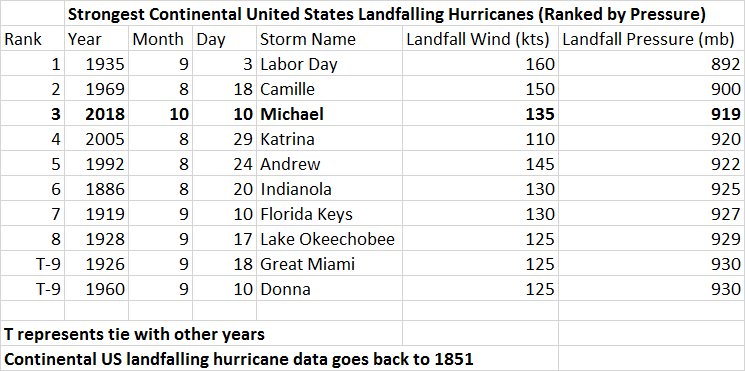
Slots into the top 3 of all time for the U.S
You do not have the required permissions to view the files attached to this post.
-
Cyclone Tracy
- Posts: 2488
- Joined: Thu 07/09/2017 19:25
- Location: North Shore, Auckland
Re: Hurricane Michael
Just looking into the projections from a week ago. The old Navy model has completely pulled down the pants of EC & GFS on picking up a solid circulation spawning from the Central American Gyre. Basically nailed it 8 days out. Special mention to the Canadians for picking up a circulation. EC & GFS don't even have a circulation of one of the greatest Hurricane's in U.S history within 8 days 
You do not have the required permissions to view the files attached to this post.
Last edited by Cyclone Tracy on Thu 11/10/2018 08:48, edited 1 time in total.
-
Cyclone Tracy
- Posts: 2488
- Joined: Thu 07/09/2017 19:25
- Location: North Shore, Auckland
Re: Hurricane Michael
Looking at the water line on the houses, that is close to a 10 foot surge ATM. https://twitter.com/WFLAJosh/status/105 ... 63968?s=20
-
Cyclone Tracy
- Posts: 2488
- Joined: Thu 07/09/2017 19:25
- Location: North Shore, Auckland
Re: Hurricane Michael
This is one of the best inside eye video's I've seen. You need sunscreen inside this one.... https://www.facebook.com/Stefan1126/vid ... 1591296138
-
Cyclone Tracy
- Posts: 2488
- Joined: Thu 07/09/2017 19:25
- Location: North Shore, Auckland
Re: Hurricane Michael
Michael now a category 3 hurricane in Georgia. Making it only the 4th major hurricane in their history. All the others 3 were all in the 1800s.
ummm and it's passed over Florida first
Starting to see brutal damage from the backend on the Florida coast
ummm and it's passed over Florida first
Starting to see brutal damage from the backend on the Florida coast
-
Cyclone Tracy
- Posts: 2488
- Joined: Thu 07/09/2017 19:25
- Location: North Shore, Auckland
Re: Hurricane Michael
Major hurricane winds 200 miles inland ….and now the nasty side effects, basically the whole state of Georgia is now on tornado watch as Supercells explode in the outer bands.
Mass structural damage on the coast https://twitter.com/bstevensnews/status ... 36256?s=20
Mass structural damage on the coast https://twitter.com/bstevensnews/status ... 36256?s=20
-
Cyclone Tracy
- Posts: 2488
- Joined: Thu 07/09/2017 19:25
- Location: North Shore, Auckland
Re: Hurricane Michael
3 tornado touch downs confirmed in North Florida in the last 2 hours.
Looking at the damage at Mexico beach Florida, it seems like a series of extreme Mesovortices have erupted around the inner eyewall.
https://twitter.com/AWxNYC/status/10501 ... 24800?s=20
Looking at the damage at Mexico beach Florida, it seems like a series of extreme Mesovortices have erupted around the inner eyewall.
https://twitter.com/AWxNYC/status/10501 ... 24800?s=20
-
NZstorm

- Posts: 11333
- Joined: Mon 10/03/2003 19:38
- Location: Grey Lynn, Auckland
-
Thunder081
- Posts: 476
- Joined: Wed 22/08/2012 00:10
- Location: Christchurch
Re: Hurricane Michael
Farrr out that is unreal! so rare I've only seen one other video where blue sky was seen on the ground in the eye of a hurricane. Dunno the name of it but it was in the early 2000s or 90s. Really interested to know what kind of conditions there has to be to create a near cloud free eye like that. Also this is the scene I'm talking about in the Day after tomorrow.Cyclone Tracy wrote: Thu 11/10/2018 08:42 This is one of the best inside eye video's I've seen. You need sunscreen inside this one.... https://www.facebook.com/Stefan1126/vid ... 1591296138
Wellington southerly front timelapse: www.youtube.com/watch?v=MBl3hsuIg2Q
-
Cyclone Tracy
- Posts: 2488
- Joined: Thu 07/09/2017 19:25
- Location: North Shore, Auckland
Re: Hurricane Michael
Yes, an incredible eye thunder081. The hurricane basically peaked on landfall which is unusual ... but it meant the inner core was completely intact with an incredibly clear eye over land.
First overhead video of Mexico beach - this place has been nuked. Looks like cat 5 damage to me. https://www.facebook.com/29034011463095 ... 854253747/
First overhead video of Mexico beach - this place has been nuked. Looks like cat 5 damage to me. https://www.facebook.com/29034011463095 ... 854253747/
-
NZstorm
- Posts: 11333
- Joined: Mon 10/03/2003 19:38
- Location: Grey Lynn, Auckland
Re: Hurricane Michael
Michael has been ranked the 3rd strongest hurricane landfall recorded in the US.
https://pbs.twimg.com/media/DpKn3L2UcAADyZ3.jpg
https://pbs.twimg.com/media/DpKn3L2UcAADyZ3.jpg
-
Cyclone Tracy
- Posts: 2488
- Joined: Thu 07/09/2017 19:25
- Location: North Shore, Auckland
Re: Hurricane Michael
Some satellite and radar imagery I've put together of Michael’s landfall for the thread. Notice how much lightning Michael is still generating on landfall around the inner eyewall. Lightning in inner eyewall is rare and only seen in the most severe tropical cyclones when they are maturing but to see it on a continental landfall..... I've never seen this.
-
Thunder081
- Posts: 476
- Joined: Wed 22/08/2012 00:10
- Location: Christchurch
Re: Hurricane Michael
Wow amazing imagery thanks for that. Basehunters Chasing have put up an amazing video of the eye too!Cyclone Tracy wrote: Fri 12/10/2018 09:29 Some satellite and radar imagery I've put together of Michael’s landfall for the thread. Notice how much lightning Michael is still generating on landfall around the inner eyewall. Lightning in inner eyewall is rare and only seen in the most severe tropical cyclones when they are maturing but to see it on a continental landfall..... I've never seen this.
Wellington southerly front timelapse: www.youtube.com/watch?v=MBl3hsuIg2Q
-
Thunder081
- Posts: 476
- Joined: Wed 22/08/2012 00:10
- Location: Christchurch
-
Cyclone Tracy
- Posts: 2488
- Joined: Thu 07/09/2017 19:25
- Location: North Shore, Auckland
Re: Hurricane Michael
i-Cyclone's is the undisputed global king of cyclone chasing. Here is his video of Michael.
-
Cyclone Tracy
- Posts: 2488
- Joined: Thu 07/09/2017 19:25
- Location: North Shore, Auckland
Re: Hurricane Michael
Press release overnight from the National Hurricane Centre. They have finished their post mortem of Michael and have upgraded him as the first Cat 5 hurricane to make landfall in the continental U.S. since Hurricane Andrew in 1992, and only the fourth on record. https://www.noaa.gov/media-release/hurr ... s-landfall
-
Simon Culling
- Posts: 2532
- Joined: Mon 23/11/2009 06:41
- Location: Tiverton, Devon, UK
Re: Hurricane Michael
A few more details on the upgrade on this blog by Bob Henson:
https://www.wunderground.com/cat6/Hurri ... 5-Landfall
https://www.wunderground.com/cat6/Hurri ... 5-Landfall
-
Thunder081
- Posts: 476
- Joined: Wed 22/08/2012 00:10
- Location: Christchurch