Page 3 of 3
Re: Low crossing NZ Oct 10th-13th
Posted: Thu 11/10/2007 15:35
by borris89
the front passed over about lunchtime here in Hawkes bay and this is wat followed. i see we have a 20+mm hail warning too.
Re: Low crossing NZ Oct 10th-13th
Posted: Thu 11/10/2007 16:46
by spwill
Very nice pics borris89.
Afternoon storms over Eastern Waikato, Northern Wiararapa and Southern Hawkes Bay.( Mostly in the Hill country)
Nice morn here 17C, cooler afternoon with showers, distant active Cb to the SE.
Re: Low crossing NZ Oct 10th-13th
Posted: Thu 11/10/2007 16:51
by Storm Struck
Rainfall event didnt come to much in the end, still a good 28mm worth though.
Sunday might be interesting keep watch

.
Nice pics Borris, i miss the sight of clouds towering away like that and hopefully to be seen sometime soon.
Cheers
Jason.
Re: Low crossing NZ Oct 10th-13th
Posted: Thu 11/10/2007 17:37
by TokWW
Some building clouds from my webcam - looking west, 5mins later was fully clouded over!!
Just light rain so far and no thunder... temp has dropped from 17ºC to 12ºC in one hour...
Re: Low crossing NZ Oct 10th-13th
Posted: Thu 11/10/2007 20:15
by David
According to a relative in Botany area of Auckland, with those showers that went through today it got extremely windy at their place. Apparently gale force but I wouldn't know unless I saw it. Maybe the cloud has a local strong down-burst? Some 50kmh gusts here but only a few.
Re: Low crossing NZ Oct 10th-13th
Posted: Thu 11/10/2007 20:22
by Michael
We had a few gusts when it rained from the west but it wasnt like a SWer here,in a SW the trees constantly in motion non stop then.
Re: Low crossing NZ Oct 10th-13th
Posted: Fri 12/10/2007 07:11
by ricky
NZstorm wrote:WxSim forecasting thunderstorms this afternoon...
What is WxSim?
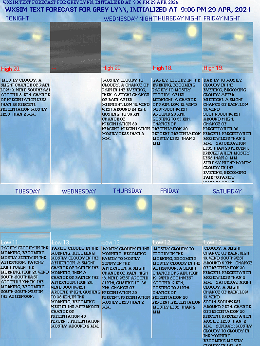
I'm running wxsim for Auckland here as well, although it never seems to be able to find much advection data from bouys etc..
here is the automatic forecast output..
http://greylynnweather.net/forecast5day.gif
Re: Low crossing NZ Oct 10th-13th
Posted: Fri 12/10/2007 07:21
by NZstorm
Interesting Ricky.
Looks like a crop of weakish cb's crossing the NI this morning. Heavy showers here in Grey Lynn atm.
Re: Low crossing NZ Oct 10th-13th
Posted: Fri 12/10/2007 13:11
by Manukau heads obs
windy here (typical for October)
with gusts to over 40 kts in the squalls this morning, but it has eased now
very frequent showers late yesterday
Re: Low crossing NZ Oct 10th-13th
Posted: Fri 12/10/2007 18:53
by David
http://www.gw.govt.nz/story6778.cfm
Already over 700mm at this Tararua ranges site this month!

Average annual rain of 7425mm in the last 7 years, 9300mm total rain in 2004
That is more than the average annual rainfall at Milford sound!
Is it possible!?
Check out the attached graph - that Feb rain total is amazing, but we do know there was a storm and bad floods around central NZ about 15th that month. June that year also had 1164mm, September 1085mm and October 1058mm there!
I've only just come across this set of rain gauges in the greater wellington area. Some huge annual rain totals for many of the Tararua ranges stations. How high are the Tararuas?
Re: Low crossing NZ Oct 10th-12th
Posted: Fri 12/10/2007 20:18
by RWood
Yes, Angle Knob is notorious, but Cropp River at "Waterfall" in the Hokitika catchment averages over 10,000mm and in one 12-month period (roughly Nov 1997-Oct 1998) recorded 18,442mm . It holds the NZ monthly record (2927mm in Dec 1995) but not the daily record (682mm at Collier Creek elsewhere in the Hok. catchment). It's mooted that there might be places upwind of the divide with 13,000+ mm rainfall.
Milford Sound is the wettest sea-level location, and its 12-month record is 10,015 mm (June 1957 - May 1958).
Re: Low crossing NZ Oct 10th-12th
Posted: Fri 12/10/2007 20:23
by David
That's so hard to imagine! That means the 18442mm in 12 months is an average of 50.5mm per day and the 2927mm in one month averaged 94.4mm per day. I can understand why they call it 'waterfall' - there must be extreme volumes of water flowing out to sea.
Re: Low crossing NZ Oct 10th-12th
Posted: Fri 12/10/2007 21:13
by tich
How high are the Tararuas?
Highest peak is about 1570m asl; several others over 1500m. Exposed to moist northwesterlies coming off the sea, and also to snow bearing southerlies.
Re: Low crossing NZ Oct 10th-12th
Posted: Fri 12/10/2007 21:45
by TokWW
Mitre Peak, North West of Masterton is 1571m (5150ft) high and Mt Holdsworth is 1470m (4820ft) high and various others close by. The Waingawa and Ruamahanga rivers merge together and feed the whole Wairarapa valley, which over 80kms long, falls only about 95m. A hot dry summer basin but the ranges take a lot of NW, SW and Southerly wet weather.
Re: Low crossing NZ Oct 10th-12th
Posted: Fri 12/10/2007 21:57
by David
Thanks for the info guys - I never actually realized the ranges around the Wairarapa/Wellington/Manawatu areas were that significant.