Page 3 of 4
Re: General November Weather
Posted: Sun 15/11/2009 23:29
by NZ Thunderstorm Soc
mikestormchaser wrote: was that thunderstorm corner those pictures John? :LOL:
NO. It was looking south or SE from here but the cloud-forms did roll out from TC.
JohnGaul
NZThS
Re: General November Weather
Posted: Mon 16/11/2009 00:10
by Storm Struck
I headed out with 03 and Aaron not much really got going until around 6pm, where some towering CU glaciated out and began precipitating.
We stuck around the Ashburton/Rakia area around back roads until about 9pm, where the clouds would develope then as they headed more eastwards began throwing out shafts all over the place.
One place we stopped there was hail on the ground, then we went abit further back west towards Ashburton where we got out and took some more photo's.
It was then we had a nice rumble of thunder overhead, before ducking for cover under the 4wd boot and filmed steady rain mixed with pea sized hail coming down.
We then headed through Leeston and out to where the Blue Duck Cafe is on the corner which segments the roads to Lyttleton and Akaroa, managing to observe a flash or two towards Akaroa way around 10pm.
Not a bad day in the end, our patience kept us going.
Another thing to note which Paul might be interested in, until about west Rolleston it was fresh NE then from there onwards it was a strong gusty NWer before coming back to a NE around Rakaia.
Photo's to follow tomorrow night

.
Re: General November Weather
Posted: Mon 16/11/2009 00:33
by Lacertae
Hey John, what time was it when you took the pictures ?
Re: General November Weather
Posted: Mon 16/11/2009 07:14
by Andrew Massie
DT-NZ wrote:Awesome pics Andrew and John
yea!!!! great to see storm pics again ... thank you - kinda going thru withdrawels... anyway... you guys are DT awesome T (dedicated thunderstorm trackers) along with Aaron and 03 who tracked and chased this evening... take care.
Cheers, Mate! We sure are! John and I are the ISOTRALAS club too!
Re: General November Weather
Posted: Mon 16/11/2009 09:25
by Paul Mallinson
Interesting pics you posted John at about 2200 hrs. Absolutely classic CB with anvil.
This was a finely balanced situation between the dry westerlies aloft, the moist easterly inflow to a convergence boundary just inland, and the cold temperatures aloft. It goes to show that thunderstorms can still trigger even with the dry westerlies aloft.
Very useful report Jasestorm. Your report of pea sized hail fits very well with our hail sizing tool (working off radar data) which indicated 4-7mm sized hail. Thanks for that.
Cheers,
Paul
Re: General November Weather
Posted: Mon 16/11/2009 10:20
by 03Stormchaser
Was a good chase, ended up being out for roughly 6 hours, dedication for ya!

Convergence line set up south of Ashburton running NE-SW, Nice CB started to form at the North of the convergence line then moved off over Bp. Pea sized hail, measured around 8mm nothing spectacular. Only heard a couple rumbles of thunder and saw 2-3 flashes toward Bp. Nice hail shafts about and took a quick detour to the rain radar site on the way south.


weather2.jpg
Left this photo out, the hail producer.
Re: General November Weather
Posted: Mon 16/11/2009 10:55
by Paul Mallinson
Nice pictures Stormchaser.
The convergence line shot is a good one and quite informative. Your 4th shot of the shaft of precip in the sunlight shows that the showers where pretty respectable.
Cheers,
Paul
Re: General November Weather
Posted: Mon 16/11/2009 11:41
by Lacertae
Nice chase guys !
Shame it all happens so late in the day at the moment ...

Re: General November Weather
Posted: Mon 16/11/2009 12:43
by NZstorm
Nice set of photos 03stormchaser
Paul wrote
It goes to show that thunderstorms can still trigger even with the dry westerlies aloft.
I think the dry westerlies down to about 850mb are good for instability and one of the reasons why Canterbury is so prone to severe hail in late spring/early summer. The Alps ensure that upper flow is dry.
Just add that its a pity Rakaia upper winds weren't available for yesterday.
Re: General November Weather
Posted: Mon 16/11/2009 13:45
by Paul Mallinson
Yes, I quite agree. If one has a good depth of moisture in the boundary layer to feed the convection, then it will certainly power up into the dry air and enhance downdrafts etc. What I was alluding to was whether there may have been too much shear. The presence of shear in Canterbury produces a goodly number of super cell storms there, and of course large hail.
Paul
Re: General November Weather
Posted: Mon 16/11/2009 13:47
by Paul Mallinson
Stormchaser, what was the time of that last picture you added (the one of the hail producing storm)?
Paul
15th November chase/photo's reports!!!
Posted: Mon 16/11/2009 19:43
by Storm Struck
I thought i would create a new topic so its easier for future reference finding instead of being in general weather which it definatly wasnt.
Perhaps the mods could move the comments from everyone about yesterdays happenings into here from the general November topic.
Ive decided to use photobucket for a change as i can get bigger photo's this way.
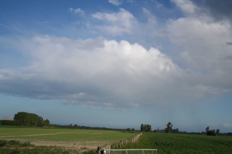
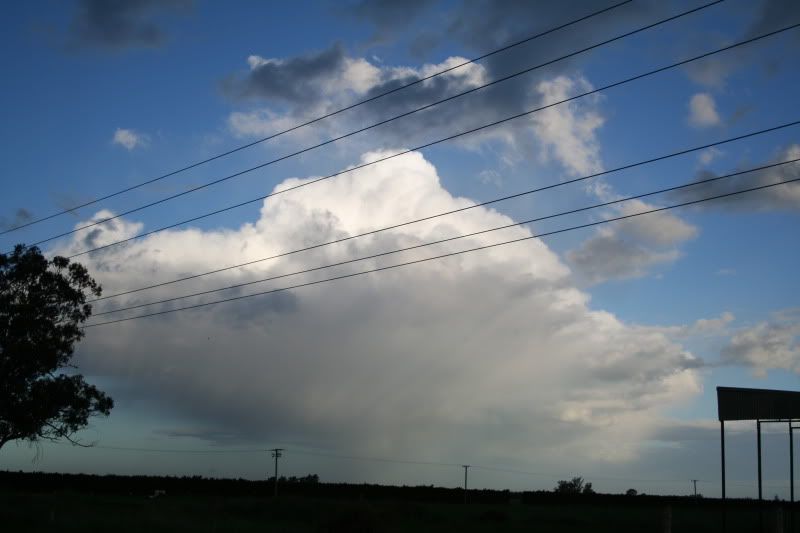
CU developing and glaciating with some precipitation also falling, east of Ashburton.
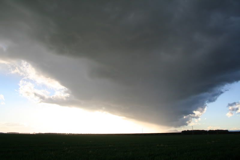
Convergence line running SE to west over us.
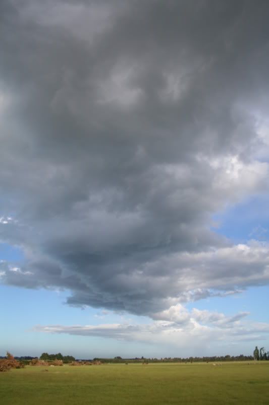
CB beginning to develope this one starting dropping hail about 10 minutes after this photo.
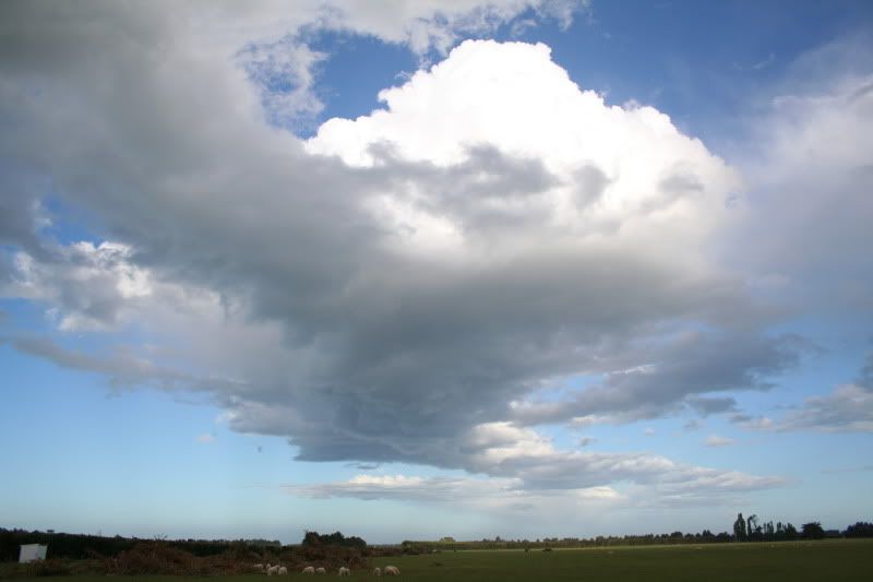
Towering CU towards the west, situated south of Rakaia area.
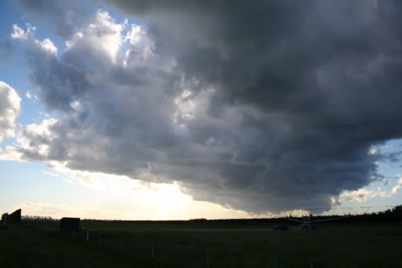
CB
Re: 15th November chase/photo's reports!!!
Posted: Mon 16/11/2009 19:47
by Storm Struck
CB Hail shower just Near Rakaia looking SE.
Nice development to the west looking towards Ashburton way, just before we had a thunder rumble overhead.
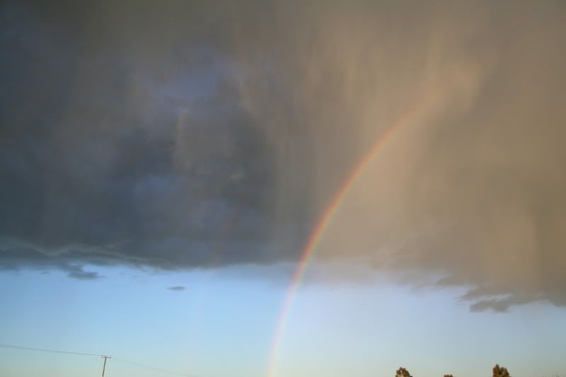
Rainbow with Hail shafts evident.
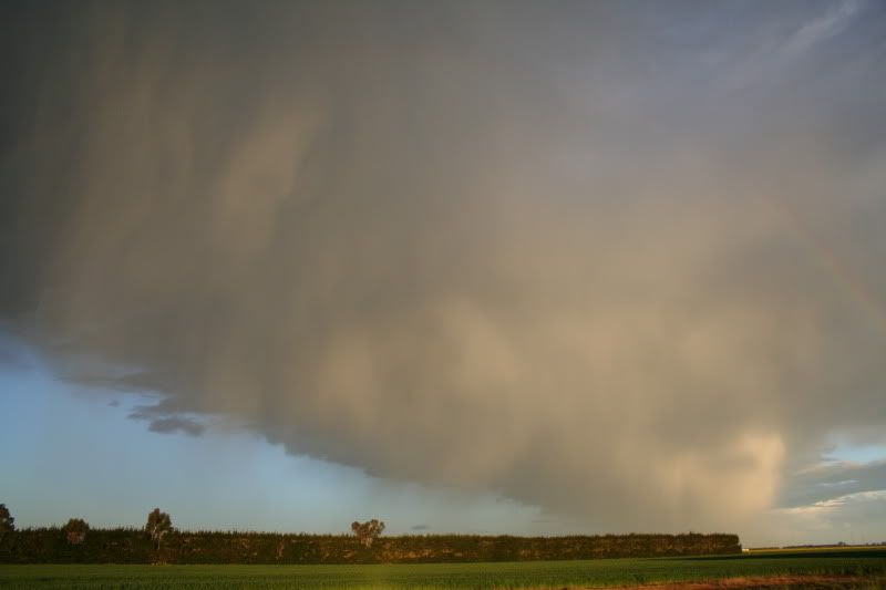
Again hail shower shafting very nicly against the sun setting.
Re: 15th November chase/photo's reports!!!
Posted: Mon 16/11/2009 20:02
by NZstorm
A very well documented convergence line there Jason.
Re: 15th November chase/photo's reports!!!
Posted: Mon 16/11/2009 20:38
by NZ Thunderstorm Soc
Nice photos there, Jase but takes a while to scroll down.
I thought today was more 'photographic'

Some shots later.
JohnGaul
NZThS
Re: 15th November chase/photo's reports!!!
Posted: Mon 16/11/2009 21:36
by Paul Mallinson
Great shots Jason. I really like the one looking along the underside of the convergence line showing the building CB on top.
Paul
Re: 15th November chase/photo's reports!!!
Posted: Mon 16/11/2009 22:56
by mikestormchaser
Yes very nice to see some pics, i disnt really think it was worth chasing yesterday but maybe i should of anyway.
Those last couple of pics are quite interesting, just with the sun set and the hail coming out of the CB looks like virga almost
Re: 15th November chase/photo's reports!!!
Posted: Mon 16/11/2009 23:09
by spwill
Good to see you guys getting out on a chase.
Did the colder upper air arrive late into Canterbury yesterday with that very late isolated development, surface conditions had been much better early in the afternoon, upper air timing looked better for North Otago with quite a lot of Cb down there in the afternoon but only one weak storm south of Oamaru as surface conditions not so good down there.
Re: 15th November chase/photo's reports!!!
Posted: Mon 16/11/2009 23:17
by Thunder
Might put a few pics up in a day or two but they are pretty much the same as what Jase and Steve have allready.
Thanks to Foggy he showed me this site:
http://zakalwe.com/rasp/listForecasts.p ... =NZSOUTH_N
It's wind / streamline model showed a convergence zone going from about the mouth of the Rakaia through to Ashburton. This is about exactly where this line formed so pretty cool, looks to be a GFS model.
Cheers
Aaron
Re: Canterbury thunderstorms - 15 November, Chase and reports
Posted: Mon 16/11/2009 23:31
by Willoughby
Jasestorm wrote:I thought i would create a new topic so its easier for future reference finding instead of being in general weather which it definatly wasnt.
Perhaps the mods could move the comments from everyone about yesterdays happenings into here from the general November topic.
Good idea. I have also snipped out the southerly change event from Friday. Nice pics Jason and Steve!
Re: General November Weather
Posted: Tue 17/11/2009 08:41
by 03Stormchaser
Paul Mallinson wrote:Stormchaser, what was the time of that last picture you added (the one of the hail producing storm)?
Paul
tbh not 100% sure, probably around 730ish......
Re: Canterbury thunderstorms - 15 November, Chase and reports
Posted: Tue 17/11/2009 09:53
by DT-NZ
Great pics Jase and 03Stormchaser
Thank you for posting them, appreciated and ... I see a couple of photogenic shots that could be entered into the Photo competition: "
Summer Thunderstorms"

Thank you all for your dedication who chased on the evening of the storm and for being an inspiration for this weather newbie
yea!!!! awesome! - take care.
Re: General November Weather
Posted: Tue 17/11/2009 10:00
by DT-NZ
Andrew Massie wrote: Cheers, Mate! We sure are! John and I are the ISOTRALAS club too!
Absolutely, and its the dedication and passion in chasing storms that comes through, and, everyone gets caught up in it (well I do
) and that is the inspiration for the rest of us to DO IT... like last month... when TG Snoopy and the rest of weather guys went chasing... talk about teamwork... anyway... you guys THUNDERSTORM ROCK!!! honestly... awesome!!!
Re: Canterbury thunderstorms - 15 November, Chase and reports
Posted: Tue 17/11/2009 22:29
by KiwiWeather
Fabulous coverage guys and great pics!
Grats Jasestorm

- 5 years !!
Re: Canterbury thunderstorms - 15 November, Chase and reports
Posted: Wed 18/11/2009 00:34
by Thunder
Few pics.


