BlueSkies Weather has it looking good from next Friday with lots of cold winds, snow on the hills and cold southerlies/easterlies, etc..
Hope it eventuates.
With all this fog, mist etc., and the unexciting weather we have been having lately, I hope, next WE outlook does something 'excitingly wintry' before spring.
JohnGaul
NZTS
Lookin' Good
Forum rules
These topics are a read-only archive and may be subject to out-of-date information.
For today's weather discussion head to: New Zealand Weather & Climate
These topics are a read-only archive and may be subject to out-of-date information.
For today's weather discussion head to: New Zealand Weather & Climate
-
NZ Thunderstorm Soc
- Posts: 18489
- Joined: Wed 12/03/2003 22:08
- Location: Raukapuka Geraldine
- Has thanked: 1769 times
- Been thanked: 1412 times
-
TonyT

- Moderator
- Posts: 2882
- Joined: Thu 08/05/2003 11:09
- Location: Amberley, North Canterbury
- Has thanked: 354 times
- Been thanked: 1152 times
Looks like a very unsettled period for most of the country from Friday onwards John, the models have several depressions developing near and around the country, so its pretty hard to come up with any definite forecasts, but somewhere is bound to get some heavy rain and strong winds out of it all, and maybe quite a few places. Doesnt look particularly cold at this stage, but you never know until nearer the time, given the potential for warm advection snow with depressions at this time of year.
-
NZ Thunderstorm Soc
- Posts: 18489
- Joined: Wed 12/03/2003 22:08
- Location: Raukapuka Geraldine
- Has thanked: 1769 times
- Been thanked: 1412 times
-
Manukau heads obs
- Posts: 12305
- Joined: Mon 10/03/2003 16:30
- Location: West Coast Road, Manukau Peninsula, North Island
- Has thanked: 0
- Been thanked: 0
- Contact:

-
TonyT
- Moderator
- Posts: 2882
- Joined: Thu 08/05/2003 11:09
- Location: Amberley, North Canterbury
- Has thanked: 354 times
- Been thanked: 1152 times
-
NZ Thunderstorm Soc
- Posts: 18489
- Joined: Wed 12/03/2003 22:08
- Location: Raukapuka Geraldine
- Has thanked: 1769 times
- Been thanked: 1412 times
-
NZstorm

- Posts: 11333
- Joined: Mon 10/03/2003 19:38
- Location: Grey Lynn, Auckland
- Has thanked: 342 times
- Been thanked: 361 times
One or two showers about Auckland today so the fine spell has ended.
The low over the north should produce plenty of rain for Northland and Coromandel. Oregraphic forcing into conditionaly unstable air is likely to produce localised high topped cb over these areas over the weekend.

Turretted Cumulus over the AK area today. There was isolated weak cb also.
The low over the north should produce plenty of rain for Northland and Coromandel. Oregraphic forcing into conditionaly unstable air is likely to produce localised high topped cb over these areas over the weekend.
Turretted Cumulus over the AK area today. There was isolated weak cb also.
-
NZ Thunderstorm Soc
- Posts: 18489
- Joined: Wed 12/03/2003 22:08
- Location: Raukapuka Geraldine
- Has thanked: 1769 times
- Been thanked: 1412 times
Not Lookin' Good
Well, the origional posting of this forum item was "Looking Good" but that hasn't eventuated as current weather pattern continue to send lows around the top of the North Island.
Looks like a week of easterly drizzle coming up with an anticyclone moving slowly east to the seas south of New Zealand.
JohnGaul
NZTS
Looks like a week of easterly drizzle coming up with an anticyclone moving slowly east to the seas south of New Zealand.
JohnGaul
NZTS
-
Manukau heads obs
- Posts: 12305
- Joined: Mon 10/03/2003 16:30
- Location: West Coast Road, Manukau Peninsula, North Island
- Has thanked: 0
- Been thanked: 0
- Contact:
http://ps.gen.nz/~hamgap/waipu.htm
shows wave clouds on the brynderwan hills, south of whangerei, as the low to the north gets more organised
this site now updated every 2 hours, and is quite exposed to the easterly/NE winds , coming straight out of Bream Bay
shows wave clouds on the brynderwan hills, south of whangerei, as the low to the north gets more organised
this site now updated every 2 hours, and is quite exposed to the easterly/NE winds , coming straight out of Bream Bay
-
NZstorm
- Posts: 11333
- Joined: Mon 10/03/2003 19:38
- Location: Grey Lynn, Auckland
- Has thanked: 342 times
- Been thanked: 361 times
Looks like there may be a return to the more usual disturbed WSW by the end of the week. Looks very much like showers and a cool southwester for the rugby at Eden Park next Saturday.
There is a bit of convective potential in the low over the north. The risk of Isolated heavy falls/thunderstorms in the north over the next day or two.
The amount of rainfall can be hard to predict in these type of situations. But as usual the Coromandel looks like its in for a soaking.
There is a bit of convective potential in the low over the north. The risk of Isolated heavy falls/thunderstorms in the north over the next day or two.
The amount of rainfall can be hard to predict in these type of situations. But as usual the Coromandel looks like its in for a soaking.
-
NZstorm
- Posts: 11333
- Joined: Mon 10/03/2003 19:38
- Location: Grey Lynn, Auckland
- Has thanked: 342 times
- Been thanked: 361 times
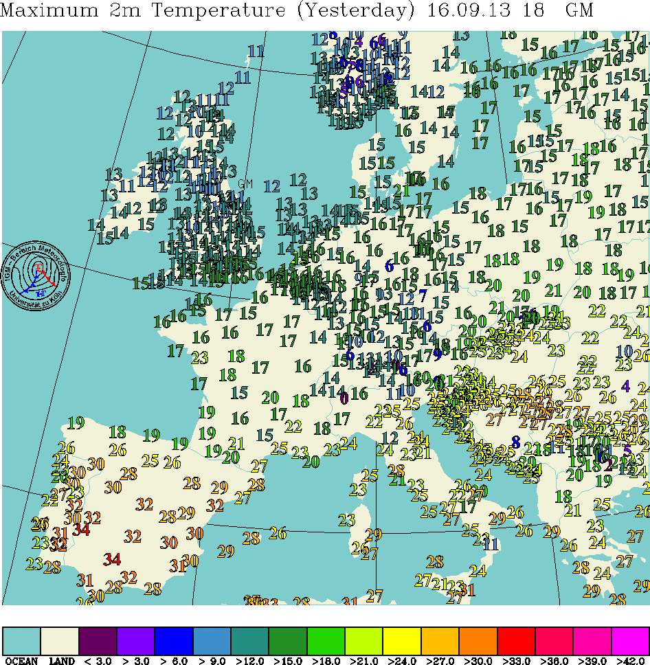
By the way, Europe is experiencing one of its hottest and driest summers on record. I wonder if this is an indication for our coming summer.
Yesterdays max temps for Europe
http://www.uni-koeln.de/math-nat-fak/ge ... pazoom.gif
Yesterdays max temps for Europe
http://www.uni-koeln.de/math-nat-fak/ge ... pazoom.gif
-
Michael

- Posts: 7210
- Joined: Thu 27/03/2003 12:04
- Location: Rainy Manurewa, Auckland - "City of Gales"
- Has thanked: 0
- Been thanked: 1 time
- Contact:
In auckland you have to be kidding  When has Auckland got 35.5C ?let alone 30 is a struggle on the best of hot days
Perhaps east coast areas can "benefit" from such heatwaves if the indication lives up
Perhaps east coast areas can "benefit" from such heatwaves if the indication lives up
NZstorm wrote:By the way, Europe is experiencing one of its hottest and driest summers on record. I wonder if this is an indication for our coming summer.
-
NZstorm
- Posts: 11333
- Joined: Mon 10/03/2003 19:38
- Location: Grey Lynn, Auckland
- Has thanked: 342 times
- Been thanked: 361 times
Michael, I am talking in relative terms. Europe is a continent, so obviously the temperatures will get very high in a hot spell.
That low over northern NZ is generating some cb's/ts this evening.
http://www.weatherzone.com.au/currentwe ... te%20Image
That low over northern NZ is generating some cb's/ts this evening.
http://www.weatherzone.com.au/currentwe ... te%20Image
-
NZ Thunderstorm Soc
- Posts: 18489
- Joined: Wed 12/03/2003 22:08
- Location: Raukapuka Geraldine
- Has thanked: 1769 times
- Been thanked: 1412 times
-
NZstorm
- Posts: 11333
- Joined: Mon 10/03/2003 19:38
- Location: Grey Lynn, Auckland
- Has thanked: 342 times
- Been thanked: 361 times
Summers of 97/98 and 98/99 where relatively hot.
February 1998 was warm...these temperatures where the average for the month.
Henderson 16C to 28C...extreme max 33.1C
Auckland Airport 18C to 27C...extreme max 29.1C
During this summer temperatures in excess of 35C where recorded in some parts of the country on a few days.
February 1998 was warm...these temperatures where the average for the month.
Henderson 16C to 28C...extreme max 33.1C
Auckland Airport 18C to 27C...extreme max 29.1C
During this summer temperatures in excess of 35C where recorded in some parts of the country on a few days.