Big Easterly Low: 24th-28th

Archive of NZ Weather & Climate
Forum rules
These topics are a read-only archive and may be subject to out-of-date information.

For today's weather discussion head to: New Zealand Weather & Climate
NZ Thunderstorm Soc
Posts: 18489
Joined: Wed 12/03/2003 22:08
Location: Raukapuka Geraldine
Has thanked: 1769 times
Been thanked: 1412 times

Unread post by NZ Thunderstorm Soc »

squid wrote:oh btw my weather station is a weathermax one oh man sorry about the typos in that last post i was trying to say that there are quite a few strikes being picked up to the NW of northland atm and that was basically it and also that we need a weather system to flush out all this humidity phew it is sticky
Thankyou.
We are having a lovely sunset at the moment. Rainbows to the north :) :)

JohnGaul
NZTS
User avatar
NZstorm
Posts: 11333
Joined: Mon 10/03/2003 19:38
Location: Grey Lynn, Auckland
Has thanked: 342 times
Been thanked: 361 times

Unread post by NZstorm »

I thought Geoff Mackley was in Yellowstone National Park filming the Supervolcano that erupted on TV One last night
Geoff works for TV3! ;)
NZ Thunderstorm Soc
Posts: 18489
Joined: Wed 12/03/2003 22:08
Location: Raukapuka Geraldine
Has thanked: 1769 times
Been thanked: 1412 times

Unread post by NZ Thunderstorm Soc »

NZstorm wrote:
I thought Geoff Mackley was in Yellowstone National Park filming the Supervolcano that erupted on TV One last night
Geoff works for TV3! ;)

....that's probably why he was in Katikati then> ;) :D :D

JohnGaul
NZTS
tich
Posts: 3470
Joined: Sat 15/03/2003 18:32
Location: Christchurch (St Albans)/Akaroa
Has thanked: 22 times
Been thanked: 92 times

Unread post by tich »

No, the 80mm we got in an hour back in May was heavy rain.
80mm in 1 hour is incredibly, stupendously (can't think of words to describe such an extreme intensity) heavy rain. The only other occasion I've heard about in NZ where that hourly total has been reached was during a thunderstorm somewhere near Alexandra in November 1992. (which involved very heavy hail)
18mm is still pretty intense, more than what I usually see on the 3 hour obs during rain events. I think anything more than 5mm in an hour is defined as heavy, according to MetService.
User avatar
Willoughby
Site Admin
Posts: 4433
Joined: Sat 14/06/2003 16:18
Location: Darwin, Australia: Storm city
Has thanked: 264 times
Been thanked: 288 times
Contact:

Unread post by Willoughby »

tich wrote:
No, the 80mm we got in an hour back in May was heavy rain.
80mm in 1 hour is incredibly, stupendously (can't think of words to describe such an extreme intensity) heavy rain. The only other occasion I've heard about in NZ where that hourly total has been reached was during a thunderstorm somewhere near Alexandra in November 1992. (which involved very heavy hail)
18mm is still pretty intense, more than what I usually see on the 3 hour obs during rain events. I think anything more than 5mm in an hour is defined as heavy, according to MetService.
Internationally it's above 6mm/h... think the Metservice use that too..

Doesn't Leigh still hold the heavy rain record?
NZ Thunderstorm Soc
Posts: 18489
Joined: Wed 12/03/2003 22:08
Location: Raukapuka Geraldine
Has thanked: 1769 times
Been thanked: 1412 times

Unread post by NZ Thunderstorm Soc »

Don't forget, Ben, NZ's record of a one hour rainfall total,was the 109mm recorded at Leigh, just north of Auckland on the 30th May 2001.
A wee bit more than a 'few spits of violent drizzle' :D

JohnGaul
NZTS
User avatar
tgsnoopy
Posts: 3653
Joined: Fri 25/03/2005 21:17
Location: Tauranga, NZ (Curse you COVID-19 :-( )
Has thanked: 816 times
Been thanked: 283 times

Unread post by tgsnoopy »

Wow, 108mm in an hour... Geepers, 80 (well 79 from memory) was bad enough. I still remember the intense noise of the rain and thinking wow that's a heavy shower.... Then thinking, uh-oh, this isn't a shower... then thinking geepers I hope this slows down or stops soon.

It was kind of hard case driving home in the 4wd with people paddling kayaks beside me. The flooding was up to the windscreens of some of the parked vans.
User avatar
Storm Struck
Posts: 4865
Joined: Wed 17/11/2004 21:25
Location: Belfast Christchurch
Has thanked: 23 times
Been thanked: 375 times

Unread post by Storm Struck »

Most heavy rain event Iv'e been in was in Golden Bay January 2001 when a thunderstorm came over dumping well from what a local in the Collingwood pub said 63mm in an hour 8) .
Maybe abit under that perhaps 50mm as it was very heavy and the camp flooded only because also the tide was in so the drains just clogged up and water lay halfway up those pup tents.
yes I seen the sunset and the rainbow unfortunatly not close enough to get the crate of cold beer ;) :lol: .
Cheers
Jason.
squid
Posts: 1304
Joined: Thu 16/06/2005 13:57
Location: Caboolture,QLD
Has thanked: 0
Been thanked: 0
Contact:

Unread post by squid »

stil alot of strikes to to west north west of northland I hope they come ashore
User avatar
Willoughby
Site Admin
Posts: 4433
Joined: Sat 14/06/2003 16:18
Location: Darwin, Australia: Storm city
Has thanked: 264 times
Been thanked: 288 times
Contact:

Unread post by Willoughby »

56mm in one hour all I can remember here in Hamilton back in 26 Nov '03 and 44mm early morning before the Tauranga floods later that day in May last year.

Oh! and 4.5mm in one MINUTE just before the chase last year.. and around that during the sep 16 tornado event :twisted:

Thats a good sign seeing that thundery rain up there squid :) would be cool to see the skys cracking up again
NZ Thunderstorm Soc
Posts: 18489
Joined: Wed 12/03/2003 22:08
Location: Raukapuka Geraldine
Has thanked: 1769 times
Been thanked: 1412 times

Unread post by NZ Thunderstorm Soc »

Coming onto rain here now, NE breezes still blowing.

JohnGaul
NZTS
tich
Posts: 3470
Joined: Sat 15/03/2003 18:32
Location: Christchurch (St Albans)/Akaroa
Has thanked: 22 times
Been thanked: 92 times

Unread post by tich »

Coming onto rain here now, NE breezes still blowing.
Only a bit of light rain overnight - more to the northeast. Cloudy this morning with a gusty southerly.
squid
Posts: 1304
Joined: Thu 16/06/2005 13:57
Location: Caboolture,QLD
Has thanked: 0
Been thanked: 0
Contact:

Unread post by squid »

very humid calm with baro of 998 something has got to give this remids me of when i lived in Far North Qld at this time of year
User avatar
Willoughby
Site Admin
Posts: 4433
Joined: Sat 14/06/2003 16:18
Location: Darwin, Australia: Storm city
Has thanked: 264 times
Been thanked: 288 times
Contact:

Unread post by Willoughby »

squid wrote:very humid calm with baro of 998 something has got to give this remids me of when i lived in Far North Qld at this time of year
So true.. im sticking up bad in 25c/dp 21c :D

Localised heavy showers being swept across the greater Auckland region curved from the NW to from the NE thanks to a bit of sunshine too
A very warm moist airmass resident over the North Island coupled with cooling temperatures aloft over central and southern areas, will produce widespread shower activity there today. The highest risk of thunderstorms is expected over southern Hawkes Bay and Wairarapa as a wind shift line moves northeast.These storms may produce rainfall amounts of 10 to 25mm/hr in some places.

Further afield, there is a moderate chance of thunderstorms and heavy showers from about Waikato, to the central plateau and around to Wanganui and Manawatu through this morning and afternoon. There, storm motions should limit rainfall amounts to about 15mm in an hour. In the Wellington area, a cold front could trigger one or two thunderstorms in the more northern parts of the district for a short time early this afternoon.

Low thunderstorms risk exist in the Auckland and Coromandel Peninsula area this morning,central and eastern parts of the Bay of Plenty this afternoon and this evening in Gisborne as a front moves northward.
-MetService
tich
Posts: 3470
Joined: Sat 15/03/2003 18:32
Location: Christchurch (St Albans)/Akaroa
Has thanked: 22 times
Been thanked: 92 times

Unread post by tich »

I notice central NI/BOP temperatures were already into the low 20s by 10am. Waiouru was on 20C - normal for most other lower areas this time of year, but most probably warmer than normal for Waiouru. If there are clear skies as well (I guess there are), I think it'll be a good set up for storms later.
ricky
Posts: 1054
Joined: Sun 28/09/2003 21:27
Location: Grey Lynn, Auckland
Has thanked: 488 times
Been thanked: 40 times
Contact:

Unread post by ricky »

Some lightning showing up there now.. coast and in from Raglan way i think...
Image
User avatar
Willoughby
Site Admin
Posts: 4433
Joined: Sat 14/06/2003 16:18
Location: Darwin, Australia: Storm city
Has thanked: 264 times
Been thanked: 288 times
Contact:

Unread post by Willoughby »

Rain shower has turned heavy now here in hamilton north.. dp 21c

12.4mm last hour in Raglan due to that thunderstorm.. :) departing?
User avatar
NZstorm
Posts: 11333
Joined: Mon 10/03/2003 19:38
Location: Grey Lynn, Auckland
Has thanked: 342 times
Been thanked: 361 times

Unread post by NZstorm »

Problem for thunderstorm development for today is all the low cloud and drizzle. Should still see Isolated Thunderstorms/heavy falls from Northland to central NI this afternoon in aeas that manage to get a bit of heating.

Current weather is Auckland is Low cloud/drizzle/Mist Temp 21C
Not good for thermal convection. :(
RWood
Posts: 3745
Joined: Sat 24/01/2004 16:56
Location: Wellington
Has thanked: 188 times
Been thanked: 123 times

Unread post by RWood »

Some periods of heavy rain from yesterday afternoon in Nelson/Marlborough, has now eased in Blenheim. May help the dry landscapes briefly.
User avatar
Willoughby
Site Admin
Posts: 4433
Joined: Sat 14/06/2003 16:18
Location: Darwin, Australia: Storm city
Has thanked: 264 times
Been thanked: 288 times
Contact:

Unread post by Willoughby »

Weather remains absolute 'crap'.. no thunder even! :( .. and if you don't happen to get saturated on the outside, you'll get saturated from sweat! :?

Poor day for photography.. but I managed a bit.

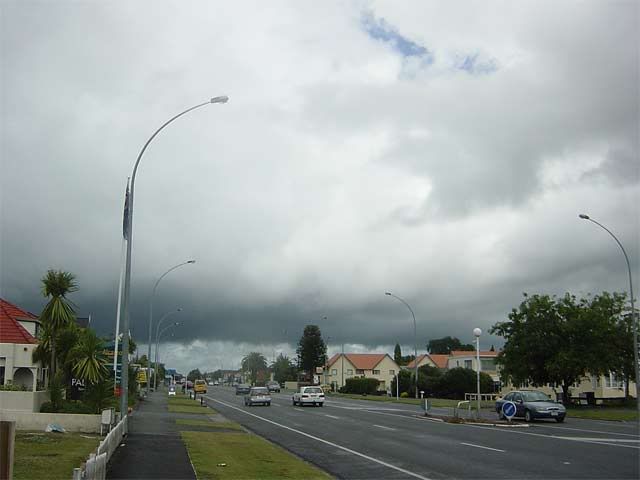
Looking SSW towards the connection of the Raglan thunderstorm this morning. Is that a shelf cloud under there?

Image

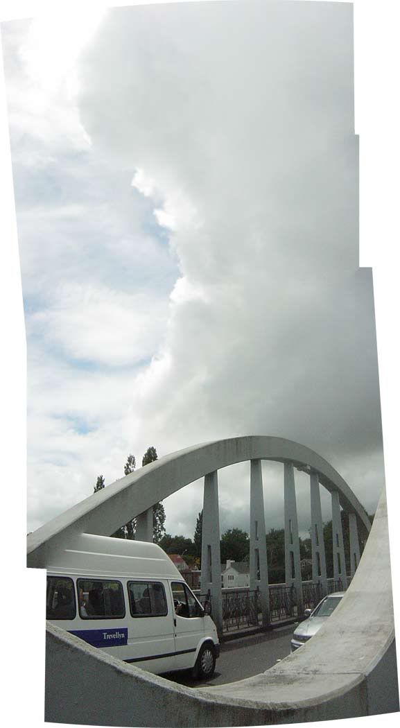
Merged photo shows strong vertical development from side of heavy shower.
Image

Low cloud from heavy showers.. basing around 150m
Image

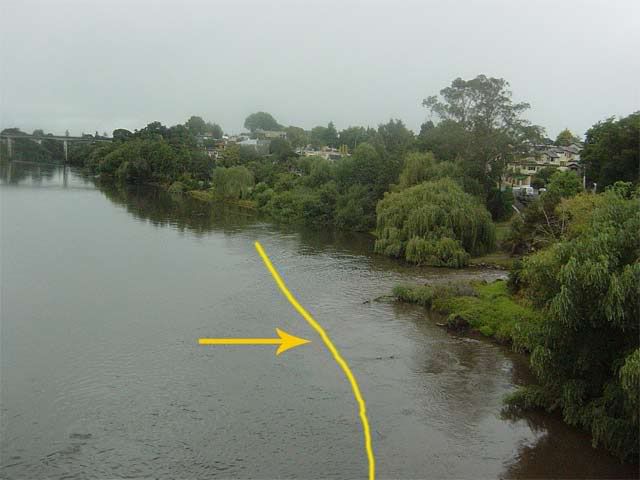
Waikato River suddenly on the rise. Yellow line indicates where it was 2 days ago.
Image
Regional picture
There has been very heavy rainfall (up to 300mm) recorded on the Coromandel and Kaimai Ranges over the past 24 hours. The heavy rain warning that was in effect for much of yesterday has now been lifted as the storm front heads south across the North Island. The Pinnacles rainfall site recorded the maximum total of 325mm over a 30 hour period (measured between 3am Tuesday 24 January to 7am Wednesday 25 January). Maximum intensities peaked at 40mm/hour.

Only the Waihou River recorder site at Te Aroha remains above alarm at this stage (9.98 metres above mean sea level). The other river systems which were above alarm last night (such as the Ohinemuri, Kauaeranga, and the Mangatangi) have all quickly receded below their alarm points this morning.

Lake Taupo’s level is currently 357.04 metres above mean sea level and rising. Lake Waikare’s level is currently 5.53 metes above mean sea level and falling.
-Environment Waikato
Edit: woah 3mm/min at my ham east station at the moment! :shock:

Edit2: localised flash floods being reported now in the Hamilton city :twisted:
squid
Posts: 1304
Joined: Thu 16/06/2005 13:57
Location: Caboolture,QLD
Has thanked: 0
Been thanked: 0
Contact:

Unread post by squid »

Lightning going off round the central NI
User avatar
Willoughby
Site Admin
Posts: 4433
Joined: Sat 14/06/2003 16:18
Location: Darwin, Australia: Storm city
Has thanked: 264 times
Been thanked: 288 times
Contact:

Unread post by Willoughby »

BOOM thunder has arrived in the great city! :D :D
User avatar
Willoughby
Site Admin
Posts: 4433
Joined: Sat 14/06/2003 16:18
Location: Darwin, Australia: Storm city
Has thanked: 264 times
Been thanked: 288 times
Contact:

Unread post by Willoughby »

Ahh dear.. sirens everywhere again. Going for a look ;)
GraemeWi
Posts: 1012
Joined: Sun 30/03/2003 18:28
Location: Hobsonville Point, Auckland
Has thanked: 36 times
Been thanked: 78 times
Contact:

Unread post by GraemeWi »

We had a couple of cbs pop up in the murk over Auckland around 3.30 - 4pm. My workmates are getting used to me now, they look out for photo oportunities :)

No pictures though.

Cheers,

G
squid
Posts: 1304
Joined: Thu 16/06/2005 13:57
Location: Caboolture,QLD
Has thanked: 0
Been thanked: 0
Contact:

Unread post by squid »

drizzle/light rain here with a SW change baro going up now 1004
Locked