Icy flick 8-10th October

Archive of NZ Weather & Climate
Forum rules
These topics are a read-only archive and may be subject to out-of-date information.

For today's weather discussion head to: New Zealand Weather & Climate
User avatar
Storm Struck
Posts: 4865
Joined: Wed 17/11/2004 21:25
Location: Belfast Christchurch
Has thanked: 23 times
Been thanked: 375 times

Icy flick 8-10th October

Unread post by Storm Struck »

Just thought I would start a new topic on this one.
There is a watch for severe NW gales in the south of the south island and north Canterbury and Marlborough this evening.
Rain should spread east overnight followed by a cool SW change and perhaps even some thunderstorms too 8) .
A real Icy grip gets hold of the far south on Monday which then moves north for Tuesday with another risk of thunder.
Now to wait and see what happens :) .
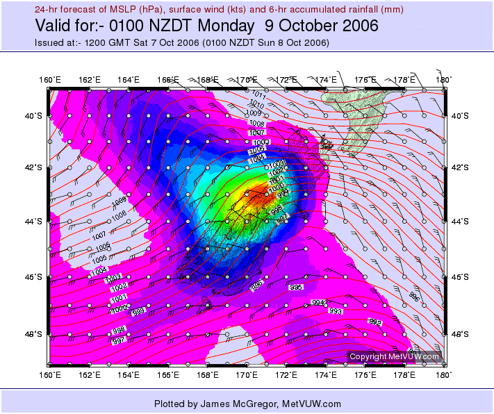
MSLP for overnight below.
Cheers
Jason.

Image
Canterbury, home of good rugby and severe storms
Flutterbye
Posts: 1261
Joined: Fri 16/12/2005 22:14
Location: Southland
Has thanked: 0
Been thanked: 9 times

Unread post by Flutterbye »

The wind watch for North Canterbury and Malborough is now a warning.
User avatar
NZstorm
Posts: 11333
Joined: Mon 10/03/2003 19:38
Location: Grey Lynn, Auckland
Has thanked: 342 times
Been thanked: 361 times

Unread post by NZstorm »

Haven't looked at any forecasts but looking at a couple of charts, snow should fall to about 300m, perhaps 200m, in the Catlins region overnight Monday.
sw_windbow
Posts: 241
Joined: Tue 13/06/2006 15:21
Location: Dunedin
Has thanked: 0
Been thanked: 0

Unread post by sw_windbow »

Hey flutterbye it looks like that first cold front is rolling into Invercargil right now. Does it look heavy?
Flutterbye
Posts: 1261
Joined: Fri 16/12/2005 22:14
Location: Southland
Has thanked: 0
Been thanked: 9 times

Unread post by Flutterbye »

Just starting to rain now - it's has been a fine day with a NNW wind that has been very strong at times. Not heavy yet. :)
Compie
Posts: 65
Joined: Wed 13/10/2004 13:49
Location: Otago Peninsula.Dunedin
Has thanked: 0
Been thanked: 0
Contact:

Unread post by Compie »

sorry I should have posted here.

Were there wind warnings for Dunedin area.

I tgell ya I gotta move off the peninsula, Nor Easters, Northerlies, Southerlies and the infamous south westerly.

What do they say, if you want a view...
User avatar
Storm Struck
Posts: 4865
Joined: Wed 17/11/2004 21:25
Location: Belfast Christchurch
Has thanked: 23 times
Been thanked: 375 times

Unread post by Storm Struck »

Yes sure is blowing a gale down south 4pm Obs have South West Cape gusting 111kmh and Puysegur point 98kmh.
Just swung Breezy northerly here after being cool fresh NE all day temp slowly going up too 16.2C here at the moment.
Cheers
Jason.
Canterbury, home of good rugby and severe storms
sw_windbow
Posts: 241
Joined: Tue 13/06/2006 15:21
Location: Dunedin
Has thanked: 0
Been thanked: 0

Unread post by sw_windbow »

Otago Port wind instruments report a 45 knot gust in the last 10 minutes, and a mean wind speed of 28 knots. Plastic bags are soaring like eagles.

A vast shadow extends across the southern horizon and its getting prematurely dim here.
Flutterbye
Posts: 1261
Joined: Fri 16/12/2005 22:14
Location: Southland
Has thanked: 0
Been thanked: 9 times

Unread post by Flutterbye »

Ended up with 5mm rain with that front - turned to the WSW about 6pm and the temperature dropped from 15° to 9°.
User avatar
03Stormchaser
Moderator
Posts: 4428
Joined: Tue 09/12/2003 12:11
Location: Prebbleton
Has thanked: 104 times
Been thanked: 184 times
Contact:

Unread post by 03Stormchaser »

Had about 10mm this morning from the southerly change. Had a look at the metservice lightning tracker shows a strike about oxford.
NZ Largest Storm Chasing Facebook Pagehttp://www.facebook.com/nzstormchasers
NZ Largest Storm Chase Community https://www.facebook.com/groups/NZStormchasersGroup
NZ Stormchasers TV https://www.youtube.com/@NZStormchasers
Andy
Posts: 1424
Joined: Tue 27/05/2003 14:15
Location: Alexandra
Has thanked: 134 times
Been thanked: 63 times

Unread post by Andy »

11mm here, and a good dusting of snow to 500m. Chilly start this moring 0° but the suns out now.
User avatar
TonyT
Moderator
Posts: 2881
Joined: Thu 08/05/2003 11:09
Location: Amberley, North Canterbury
Has thanked: 354 times
Been thanked: 1152 times

Unread post by TonyT »

About half a dozen flashes observed here around 11pm last night, at a time of near gale NW winds, probably storms on the ranges.
tich
Posts: 3470
Joined: Sat 15/03/2003 18:32
Location: Christchurch (St Albans)/Akaroa
Has thanked: 22 times
Been thanked: 92 times

Unread post by tich »

A period of rain overnight on Banks Peninsula, plus a coating of snow down as low as 450m. :o Much colder change than expected, but skies have cleared now.
spwill
Posts: 9918
Joined: Sun 29/06/2003 22:39
Location: Mt Eden Auckland
Has thanked: 847 times
Been thanked: 869 times

Unread post by spwill »

plus a coating of snow down as low as 450m.
Currently 10c in Chch but dew points are only 3C, chilly air.

Cb cloud moving into South Tasman this morning looks impressive.
Snowlover
Posts: 168
Joined: Thu 06/07/2006 14:09
Location: Redwood, Christchurch
Has thanked: 0
Been thanked: 0

Unread post by Snowlover »

I see metservice is forecasting snow to 300m in canterbury tomorrow!!! :shock: may see some sleet in christchurch?
Snowlover
Posts: 168
Joined: Thu 06/07/2006 14:09
Location: Redwood, Christchurch
Has thanked: 0
Been thanked: 0

Unread post by Snowlover »

also snow to sea level in the south tomorrow!!!! eg dunedin, invercargill etc
sw_windbow
Posts: 241
Joined: Tue 13/06/2006 15:21
Location: Dunedin
Has thanked: 0
Been thanked: 0

Unread post by sw_windbow »

Metservice say we're in for Thundery showers this arvo! Last thundery showers I can remember in Dunedin City were 13 months ago.
User avatar
Willoughby
Site Admin
Posts: 4433
Joined: Sat 14/06/2003 16:18
Location: Darwin, Australia: Storm city
Has thanked: 264 times
Been thanked: 288 times
Contact:

Unread post by Willoughby »

Looks like up north we'll finally get a strong SW'er!
Gusts to 80km/h and easing during Tuesday.

Waiting for rain...
Flutterbye
Posts: 1261
Joined: Fri 16/12/2005 22:14
Location: Southland
Has thanked: 0
Been thanked: 9 times

Unread post by Flutterbye »

The front has arrived after a sunny morning, the wind is a gusty WNW and temp has dropped from 13° down to 7°
mikestormchaser
Posts: 2711
Joined: Sat 03/06/2006 20:11
Location: Rolleston, Canterbury
Has thanked: 355 times
Been thanked: 607 times

Unread post by mikestormchaser »

there has been some really nice cu gone up in the last 3 hours or so 8) with a cb heading over to the peninsula, although it would be nice it came over CHCH. :) With a mix of this cold and hot air about we are very much likely to get thunder.Proberbly more a chance tonight though for christchurch.And snow down to sea level in the south? :shock:
or would it be just to low levels? ;)
Mike
Stormchasers.co.nz
Flutterbye
Posts: 1261
Joined: Fri 16/12/2005 22:14
Location: Southland
Has thanked: 0
Been thanked: 9 times

Unread post by Flutterbye »

tornadoman18 wrote:there has been some really nice cu gone up in the last 3 hours or so 8) with a cb heading over to the peninsula, although it would be nice it came over CHCH. :) With a mix of this cold and hot air about we are very much likely to get thunder.Proberbly more a chance tonight though for christchurch.And snow down to sea level in the south? :shock:
or would it be just to low levels? ;)
I can't see the 'sea level' snow happening. :lol:
Razor
Moderator
Posts: 5131
Joined: Fri 10/02/2006 15:14
Location: Halswell, Christchurch
Has thanked: 718 times
Been thanked: 930 times

Unread post by Razor »

I'm officially concerned that I may have to take an ice axe on my Kaweka/ Kaimanawas traverse next week. More heavy snow to 800m in the Central North Island :shock: :twisted:
Christchurch Rocks
Manukau heads obs
Posts: 12305
Joined: Mon 10/03/2003 16:30
Location: West Coast Road, Manukau Peninsula, North Island
Has thanked: 0
Been thanked: 0
Contact:

Unread post by Manukau heads obs »

this weather page gives pretty good info for southland south coast area....nice and exposed location:
http://homepages.slingshot.co.nz/~cj.mo ... ather.html
Image
Brian Hamilton, weather enthusiast. My weather dataEmail: [email protected]
Razor
Moderator
Posts: 5131
Joined: Fri 10/02/2006 15:14
Location: Halswell, Christchurch
Has thanked: 718 times
Been thanked: 930 times

Unread post by Razor »

What is this...June???? I thought it was October

I think this is a bit more than an icy 'flick' by the reports (Sourced from Newstalk ZB)

Snow forecast for South Island
9/10/2006 16:28:03

A major snow storm is forecast to hit the south of New Zealand tonight, sparking serious fears for farmers.

Snow is set to fall in Invercargill, Queenstown and Dunedin overnight and tomorrow morning. From 6pm tonight until noon Tuesday, 15 to 20cms of snow is likely from 300 metres up, with lighter falls to sea level.

Newstalk ZB weather commentator Philip Duncan says farmers need to do what they can immediately to protect lambs and calves.

Thunderstorms will move up the region this afternoon with snow falling this evening - the heaviest falls will be tomorrow morning.

However, there is some good news - strong to gale force north westerlies are expected in the South later in the week we should warm things up quite quickly.
Christchurch Rocks
tich
Posts: 3470
Joined: Sat 15/03/2003 18:32
Location: Christchurch (St Albans)/Akaroa
Has thanked: 22 times
Been thanked: 92 times

Unread post by tich »

with a cb heading over to the peninsula, although it would be nice it came over CHCH.
I saw that dark cloud to the south - 4pm radar showed it passing just to the south of the peninsula. I think it's unusual in a westerly flow to get cbs/thunderstorm clouds in Canterbury east of the mountains.
Locked