Cold outbreak, first week of September
Forum rules
These topics are a read-only archive and may be subject to out-of-date information.
For today's weather discussion head to: New Zealand Weather & Climate
These topics are a read-only archive and may be subject to out-of-date information.
For today's weather discussion head to: New Zealand Weather & Climate
-
gllitz

- Posts: 1335
- Joined: Wed 04/01/2006 11:45
- Location: Perth, Western Australia
- Has thanked: 0
- Been thanked: 0
Re: Spring like pattern for the next 4-5days!!!
This does not look very spring-like.... 
 (still about 96-120 hours away, so we'll see...)
You do not have the required permissions to view the files attached to this post.
"Saru mo ki kara ochiru"
-
gopolks
- Posts: 706
- Joined: Thu 22/03/2007 16:48
- Location: Canterbury
- Has thanked: 0
- Been thanked: 0
- Contact:
Re: Spring like pattern for the next 4-5days!!!
gllitz wrote:This does not look very spring-like....
hehehehehehehe, we will see.
-
NZ Thunderstorm Soc
- Posts: 18491
- Joined: Wed 12/03/2003 22:08
- Location: Raukapuka Geraldine
- Has thanked: 1769 times
- Been thanked: 1414 times
Re: Cold outbreak, first week of September
Surface barometer a bit high so nothing much really even though the oncoming anticyclone is up around the 1040hPa mark.
Could be a '1030hPa Scenario' though here in canterbury?????
JohnGaul
NZTS
Could be a '1030hPa Scenario' though here in canterbury?????
JohnGaul
NZTS
JohnGaul
NZThS
NZThS
-
Storm Struck

- Posts: 4871
- Joined: Wed 17/11/2004 21:25
- Location: Belfast Christchurch
- Has thanked: 23 times
- Been thanked: 392 times
Re: Cold outbreak, first week of September
I think if models hold it together the way they keep improving for this system then it could be quite significant.
Definatly much more in favour than apposed to 1030 scenario.
Not going to jump into this yet though however with some rather welcome totals of rain and very low level snow maybe we are not quite into spring just yet. ( even though we could be saying that for months on end like last year
  ).
).
Cheers
Jason.
Definatly much more in favour than apposed to 1030 scenario.
Not going to jump into this yet though
Cheers
Jason.
Canterbury, home of good rugby and severe storms
-
tich
- Posts: 3473
- Joined: Sat 15/03/2003 18:32
- Location: Christchurch (St Albans)/Akaroa
- Has thanked: 22 times
- Been thanked: 92 times
Re: Cold outbreak, first week of September
According to GFS and GASP, thickness levels are predicted to be low enough that snow should fall to sea-level not only in east of South Island, but possibly even the south of the North Island. MetService seems to be more conservative than Blue Skies about this upcoming event, with snow to only 500 in the south.
-
David

- Posts: 7587
- Joined: Sat 18/08/2007 21:02
- Location: Howick, Auckland
- Has thanked: 418 times
- Been thanked: 832 times
- Contact:
Re: Cold outbreak, first week of September
See how cold 500hpa temps forecast to be, around -32C! Would could this mean??? 
Some instability?
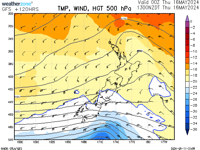
Image seems to be unavailable at times
Some instability?
Image seems to be unavailable at times
-
mikestormchaser
- Posts: 2713
- Joined: Sat 03/06/2006 20:11
- Location: Rolleston, Canterbury
- Has thanked: 356 times
- Been thanked: 608 times
Re: Cold outbreak, first week of September
you just did jump into itJasestrm wrote: Not going to jump into this yet though
Cheers
Jason.
Mike
Stormchasers.co.nz
Stormchasers.co.nz
-
Willoughby

- Site Admin
- Posts: 4433
- Joined: Sat 14/06/2003 16:18
- Location: Darwin, Australia: Storm city
- Has thanked: 264 times
- Been thanked: 288 times
- Contact:
Re: Cold outbreak, first week of September
Good spotting, and yes, WOW! That 00z GFS run shows -35C pushing -37C @ 500mb over the central North Island! 
Yeah, it's a little while away.. but nice to see a strong upper-trough on the cards again.
Looks like GASP is up to tricks again... ...519dm over Invercargill? Surely not, surely! 
But here it is for justice.
Yeah, it's a little while away.. but nice to see a strong upper-trough on the cards again.
Looks like GASP is up to tricks again...
Weatherzone don't allow 'hotlinking'.David wrote:Image seems to be unavailable at times
But here it is for justice.
You do not have the required permissions to view the files attached to this post.
-
David
- Posts: 7587
- Joined: Sat 18/08/2007 21:02
- Location: Howick, Auckland
- Has thanked: 418 times
- Been thanked: 832 times
- Contact:
Re: Cold outbreak, first week of September
Foggy, how do I upload an image from the internet so it is an attachment?
-
TokWW
- Posts: 435
- Joined: Wed 02/05/2007 08:27
- Location: Parkdale, Tokoroa
- Has thanked: 0
- Been thanked: 0
- Contact:
Re: Cold outbreak, first week of September
David - some sites allow an image to be "borrowed" once or twice then they block any further downloads to a particular site - like this forum's server - and all you see is an alarm or false image. Often it is due to copyrighting their images or their professional resources to those who are registered and have a license to view - like a subscription to a magazine - so all you can do is to copy the image to your own website and absorb the extra dead weight in volume storage, and link with img statement or you save to your own PC, make it smaller if necessary due to the forum's limits 100kB per image I think, and then upload onto the forum's pages as a permanent image there as Foggy has done.
HTH
Graeme
HTH
Graeme
A Father can have a hobby because he is the Transport, Referee, Manager, Committee Member Dad!!
LaCrosse WS-2308CH, Sharp VideoCam, ULD Lightning Radar

http://www.inmanavenue.com/
LaCrosse WS-2308CH, Sharp VideoCam, ULD Lightning Radar
http://www.inmanavenue.com/
-
melja
- Posts: 2202
- Joined: Sun 11/06/2006 20:57
- Location: Waikawa, Picton
- Has thanked: 0
- Been thanked: 74 times
Re: Cold outbreak, first week of September
I see that blue skies are going for a more south canterbury event now 
-
Inny Binny
- Posts: 553
- Joined: Sat 01/09/2007 12:15
- Location: Prebbleton
- Has thanked: 0
- Been thanked: 0
Re: Cold outbreak, first week of September
I'm new here, and only fifteen...but I've been reading through this forum for a while now.
I wouldn't give up hope on the snow for the rest of Canterbury yet.
"Canterbury High Country Snow Forecast
Issued 10:47 AM Saturday 1 September 2007
By Blue Skies Weather & Climate Services Ltd
Situation
A strong northwesterly airflow is increasing over New Zealand today ahead of a cold front. This front will move over the country tonight and tomorrow with a brief period fine southwesterlies. The airflow should tend back to the northwest on Monday, ahead of another cold front due on Tuesday. A very cold southerly airflow will spread over New Zealand on Tuesday night and Wednesday as a large anticyclone moves across the Tasman Sea, the anticyclone covering the country from Thursday.
Snow Forecast for Canterbury High Country :
A cold outbreak will spread a south to southeasterly airflow over Canterbury during Tuesday, becoming coldest from Tuesday evening through Wednesday afternoon.
A period of rain on Tuesday will see snow levels lowering during the day, with falls of 10-15cm likely above 500m. Falls may be heavier in South Canterbury with 20-30cm possible above 500m.
From Tuesday evening to Wednesday evening snow showers are likely to sea level. Showers may be heavy in South Canterbury on Tuesday and at first on Wednesday then easing. Expect accumulations of 3-5cm to sea level, 10-20cm above 200m, and a further 10-20cm above 500m.
In Mid and North Canterbury expect accumulations of 1-3cm to sea level, 5-10cm above 200m, and a further 5-10cm above 500m.
Showers should clear late on Wednesday, leaving heavy frosts on Thursday and Friday."
This system is looking very interesting...
-
southernthrash
- Posts: 339
- Joined: Sun 12/08/2007 15:48
- Location: Invercargill / Dunedin / Queenstown
- Has thanked: 0
- Been thanked: 0
Re: Cold outbreak, first week of September
Typical spring time snowfall, happens areound lambing time every year! Gary will be gutted.
-
Storm Struck
- Posts: 4871
- Joined: Wed 17/11/2004 21:25
- Location: Belfast Christchurch
- Has thanked: 23 times
- Been thanked: 392 times
Re: Cold outbreak, first week of September
Welcome to the forum inny binny great to see another cantab weather enthusiast.
The snow will possibly lower to sea level by Tuesday night by which time they will be showers so yes acummulations at or near sea level will be minimal.
However if it stays cold enough over the duration of this outbreak there shouldnt be too much snow melt and of course provided the showers are quite scatterd to prolonged.
I have a watch out on my website at the moment but I havnt put out any accumulations as I thought it is best to wait until closer to the time to get a better idea, but feel free to have a look.
I hope the models keep up as every model run just gets better .
Cheers
Jason.
The snow will possibly lower to sea level by Tuesday night by which time they will be showers so yes acummulations at or near sea level will be minimal.
However if it stays cold enough over the duration of this outbreak there shouldnt be too much snow melt and of course provided the showers are quite scatterd to prolonged.
I have a watch out on my website at the moment but I havnt put out any accumulations as I thought it is best to wait until closer to the time to get a better idea, but feel free to have a look.
I hope the models keep up as every model run just gets better
Cheers
Jason.
Canterbury, home of good rugby and severe storms
-
David
- Posts: 7587
- Joined: Sat 18/08/2007 21:02
- Location: Howick, Auckland
- Has thanked: 418 times
- Been thanked: 832 times
- Contact:
Re: Cold outbreak, first week of September
Taranaki has high risk of thunderstorms this evening and tonight, possible gusts to 110km/h and a low risk of tornadoes with the passage of the front.
Unfortunately the front is meant to quickly weaken and only bring a few showers here
Yes welcome to the forum I thought I was the youngest on here 16 turning 17 two months
Unfortunately the front is meant to quickly weaken and only bring a few showers here
Yes welcome to the forum I thought I was the youngest on here 16 turning 17 two months
-
Inny Binny
- Posts: 553
- Joined: Sat 01/09/2007 12:15
- Location: Prebbleton
- Has thanked: 0
- Been thanked: 0
Re: Cold outbreak, first week of September
Mm, I always seem to be the youngest on forums like these.
I would say that Christchurch, at the moment, might get a maximum of about what we got last year (3 - 4 cm?), but we'll see closer to the time.
I would say that Christchurch, at the moment, might get a maximum of about what we got last year (3 - 4 cm?), but we'll see closer to the time.
-
southernthrash
- Posts: 339
- Joined: Sun 12/08/2007 15:48
- Location: Invercargill / Dunedin / Queenstown
- Has thanked: 0
- Been thanked: 0
Re: Cold outbreak, first week of September
At this time of the year, accumulation is going to be affected by increased ground temp too, this has been really noticeable around queenstown over the last few days.
-
kiwisk8er

- Posts: 332
- Joined: Mon 03/04/2006 13:17
- Location: Mosgiel, Dunedin 20 m ASL
- Has thanked: 24 times
- Been thanked: 46 times
Re: Cold outbreak, first week of September
Do you think there might be any snow for Dunedin?
I know I'm wishing ...
I know I'm wishing ...
-
Inny Binny
- Posts: 553
- Joined: Sat 01/09/2007 12:15
- Location: Prebbleton
- Has thanked: 0
- Been thanked: 0
Re: Cold outbreak, first week of September
I would have said that Dunedin has had their fair share of snow...it's now our turn. 
-
David
- Posts: 7587
- Joined: Sat 18/08/2007 21:02
- Location: Howick, Auckland
- Has thanked: 418 times
- Been thanked: 832 times
- Contact:
Re: Cold outbreak, first week of September
What about up here where we NEVER get snow, or even sleet? 
The closest I've been to snow was on Y12 Tongariro National Park trip in May, and there was a patch of snow on the summit of Ruapehu.
Never got close though
At least we get thunderstorms
The closest I've been to snow was on Y12 Tongariro National Park trip in May, and there was a patch of snow on the summit of Ruapehu.
Never got close though
At least we get thunderstorms
-
Inny Binny
- Posts: 553
- Joined: Sat 01/09/2007 12:15
- Location: Prebbleton
- Has thanked: 0
- Been thanked: 0
Re: Cold outbreak, first week of September
Well apart from the occasional snow and occasional storm, weather here is very mundane...
Metservice seem to be turning over a bit more towards Blue Skies' view as well.
Metservice seem to be turning over a bit more towards Blue Skies' view as well.
-
gopolks
- Posts: 706
- Joined: Thu 22/03/2007 16:48
- Location: Canterbury
- Has thanked: 0
- Been thanked: 0
- Contact:
Re: Cold outbreak, first week of September
Yep the forcast for chch for tuesday and wednesday is a high of 15 and a high of 11. The low for both days is 5.
Down south canterbury way though it will be a lot colder.
Down south canterbury way though it will be a lot colder.
-
mikestormchaser
- Posts: 2713
- Joined: Sat 03/06/2006 20:11
- Location: Rolleston, Canterbury
- Has thanked: 356 times
- Been thanked: 608 times
Re: Cold outbreak, first week of September
Fantastic day here in Chch today, nice and warm and when finishing work at midday i can get out and enjoy it! yeha come on let it snow, haven't had a decent snow fall this year yet in cantab.
And NO kiwi sk8ter its not going to snow in dunners, u guys have had your fair share down there and the rest!
And NO kiwi sk8ter its not going to snow in dunners, u guys have had your fair share down there and the rest!
Mike
Stormchasers.co.nz
Stormchasers.co.nz
-
Inny Binny
- Posts: 553
- Joined: Sat 01/09/2007 12:15
- Location: Prebbleton
- Has thanked: 0
- Been thanked: 0
Re: Cold outbreak, first week of September
Exactly. It will only snow in Canterbury.
I'm sure that the forcasted tempertaure doesn't matter that much...for example Invercargill's temperature is supposed to be 11 and 3, and they're supposed to get sleet.
I'm sure that the forcasted tempertaure doesn't matter that much...for example Invercargill's temperature is supposed to be 11 and 3, and they're supposed to get sleet.
-
David
- Posts: 7587
- Joined: Sat 18/08/2007 21:02
- Location: Howick, Auckland
- Has thanked: 418 times
- Been thanked: 832 times
- Contact:
Re: Cold outbreak, first week of September
Metservice mentions the possibility of heavy snow in Canterbury in the severe weather outlook page.