Low/NW flow ... 23th-25th Aug
Forum rules
These topics are a read-only archive and may be subject to out-of-date information.
For today's weather discussion head to: New Zealand Weather & Climate
These topics are a read-only archive and may be subject to out-of-date information.
For today's weather discussion head to: New Zealand Weather & Climate
-
jamie
- Posts: 5907
- Joined: Fri 25/02/2011 21:35
- Location: Hamilton NZ
- Has thanked: 22 times
- Been thanked: 273 times
- Contact:
Re: Low/NW flow ... 23th-25th Aug
i cant tell. i can only just see it as i cant see that way... hope its moving towards the city. Of what i can see it looks good
-
David

- Posts: 7588
- Joined: Sat 18/08/2007 21:02
- Location: Howick, Auckland
- Has thanked: 420 times
- Been thanked: 832 times
- Contact:
Re: Low/NW flow ... 23th-25th Aug
its a battle of convergence! who knows where its going! it looks like the new cell to the SSE of me is going to the NNE, but the thunder came back some time ago and is getting rather loud again... 
Only 1.6mm fell in the first cell that went over. The next one is so dark, and can see lightning forks from it!
Only 1.6mm fell in the first cell that went over. The next one is so dark, and can see lightning forks from it!
You do not have the required permissions to view the files attached to this post.
-
jamie
- Posts: 5907
- Joined: Fri 25/02/2011 21:35
- Location: Hamilton NZ
- Has thanked: 22 times
- Been thanked: 273 times
- Contact:
Re: Low/NW flow ... 23th-25th Aug
5pm radar looks interesting. Quite a few red dots about the NI and even the odd purple dot. (i save the image then open it and zoom right in)
I seem to be getting a better view as time goes by so i suspect it might be moving this way.
I seem to be getting a better view as time goes by so i suspect it might be moving this way.
-
Manukau heads obs
- Posts: 12305
- Joined: Mon 10/03/2003 16:30
- Location: West Coast Road, Manukau Peninsula, North Island
- Has thanked: 0
- Been thanked: 0
- Contact:
Re: Low/NW flow ... 23th-25th Aug
bit of a wall cloud viewable from here just south of mt wellington or theraabouts
my webcam animation shows it is drifting north
SSW wind here
my webcam animation shows it is drifting north
SSW wind here
Last edited by Manukau heads obs on Mon 25/08/2008 17:28, edited 1 time in total.

-
NZstorm

- Posts: 11333
- Joined: Mon 10/03/2003 19:38
- Location: Grey Lynn, Auckland
- Has thanked: 342 times
- Been thanked: 361 times
Re: Low/NW flow ... 23th-25th Aug
I watched that cb go up over east Auckland, could see the CG's from Milford on the Northshore where I was working! It is still putting out lightning, considering going after a lightning photo.
-
David
- Posts: 7588
- Joined: Sat 18/08/2007 21:02
- Location: Howick, Auckland
- Has thanked: 420 times
- Been thanked: 832 times
- Contact:
Re: Low/NW flow ... 23th-25th Aug
Yes NZstorm, still a few loud bangs in the skies around me. Had a heavy shower with the cell just gone over (4mm now). No sign of any hail though.
Just another loud crack of thunder
Just another loud crack of thunder
-
Achten
- Posts: 141
- Joined: Thu 20/03/2003 20:57
- Location: Hawkes Bay
- Has thanked: 0
- Been thanked: 19 times
- Contact:
Re: Low/NW flow ... 23th-25th Aug
Thunder here as well, not overhead more west of me. Nice display though.
-
Manukau heads obs
- Posts: 12305
- Joined: Mon 10/03/2003 16:30
- Location: West Coast Road, Manukau Peninsula, North Island
- Has thanked: 0
- Been thanked: 0
- Contact:
Re: Low/NW flow ... 23th-25th Aug
another overshooting top just gone up...will be great if it stays active until it gets dark
I saw a bolt from way over here too
I saw a bolt from way over here too
-
Manukau heads obs
- Posts: 12305
- Joined: Mon 10/03/2003 16:30
- Location: West Coast Road, Manukau Peninsula, North Island
- Has thanked: 0
- Been thanked: 0
- Contact:
Re: Low/NW flow ... 23th-25th Aug
not much lightning happening...but the CB further south in the north waikato I have seen a few flashes from
-
Vertigo

- Posts: 1184
- Joined: Sun 09/12/2007 23:50
- Location: Henderson, Auckland
- Has thanked: 0
- Been thanked: 12 times
Re: Low/NW flow ... 23th-25th Aug
went to one tree hill rather than chase it, as it was moving at a snails pace
saw a very nice wall cloud on its south-western side, and shortly after, a rain core started dumping out of it. behind that i started to make out a funnel cloud. wasnt big at first, but quickly developed, and almost became a tornado from the looks of it! fortunately (or un-), it weakened and disappated. if it had held out a little longer, it would have developed over the water, and who knows what it would have done! (i desperately need a camera).
multiple CG strikes, but lightning ceased after about 5:40. twas a multicell storm, youre right brian, the second was getting going as i left. if we have a nnw flow at the moment, we might get more through the night, fingers crossed.
saw a very nice wall cloud on its south-western side, and shortly after, a rain core started dumping out of it. behind that i started to make out a funnel cloud. wasnt big at first, but quickly developed, and almost became a tornado from the looks of it! fortunately (or un-
multiple CG strikes, but lightning ceased after about 5:40. twas a multicell storm, youre right brian, the second was getting going as i left. if we have a nnw flow at the moment, we might get more through the night, fingers crossed.
-
Manukau heads obs
- Posts: 12305
- Joined: Mon 10/03/2003 16:30
- Location: West Coast Road, Manukau Peninsula, North Island
- Has thanked: 0
- Been thanked: 0
- Contact:
Re: Low/NW flow ... 23th-25th Aug
cool on the wall cloud/funnel cloud...I could see it looked good from way over this side of the harbour
hopefully someone got a photo of it
hopefully someone got a photo of it
-
NZstorm
- Posts: 11333
- Joined: Mon 10/03/2003 19:38
- Location: Grey Lynn, Auckland
- Has thanked: 342 times
- Been thanked: 361 times
Re: Low/NW flow ... 23th-25th Aug
Air looks unstable again tomorrow but with a weak SW flow.
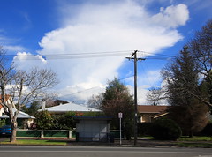
Photo here of building thunderhead to SE of Auckland mid afternoon taken from up on the North Shore.
Photo here of building thunderhead to SE of Auckland mid afternoon taken from up on the North Shore.
You do not have the required permissions to view the files attached to this post.
-
jamie
- Posts: 5907
- Joined: Fri 25/02/2011 21:35
- Location: Hamilton NZ
- Has thanked: 22 times
- Been thanked: 273 times
- Contact:
Re: Low/NW flow ... 23th-25th Aug
Hmmm just saw a flash... strange that things are still active this late.
-
Willoughby

- Site Admin
- Posts: 4433
- Joined: Sat 14/06/2003 16:18
- Location: Darwin, Australia: Storm city
- Has thanked: 264 times
- Been thanked: 288 times
- Contact:
Re: Low/NW flow ... 23th-25th Aug
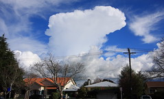
GREAT Photo there Steven I've noticed these setups are quite favourable in late August.
I just wish I had my camera on me this evening! Had a beautiful strong Cb develop just to the east of here just before dusk, nice solid round base and even had a green tinge in the cell, something you don't often see in NZ. And it kept on towering too past dusk.
Got to 18C here today.
Yes Steven, looks like the low level moisture will stick around into tomorrow - certainly a high risk of thunderstorms over Northern Waikato based on the 06Z run of the GFS. I'll have my camera ready!
-
Vertigo
- Posts: 1184
- Joined: Sun 09/12/2007 23:50
- Location: Henderson, Auckland
- Has thanked: 0
- Been thanked: 12 times
Re: Low/NW flow ... 23th-25th Aug
very overcast today, seems we have a localised cloud layer. the rain radar seems to indicate the presence of a weak meso-low?
You do not have the required permissions to view the files attached to this post.
-
Manukau heads obs
- Posts: 12305
- Joined: Mon 10/03/2003 16:30
- Location: West Coast Road, Manukau Peninsula, North Island
- Has thanked: 0
- Been thanked: 0
- Contact:
Re: Low/NW flow ... 23th-25th Aug
yes, bit of low moved up past us this morning (a few showers here), rain radar showed nicely the rotating rain bands
i think possibly mt taranaki/cook straight might be set off the rotation?
i think possibly mt taranaki/cook straight might be set off the rotation?
-
Willoughby
- Site Admin
- Posts: 4433
- Joined: Sat 14/06/2003 16:18
- Location: Darwin, Australia: Storm city
- Has thanked: 264 times
- Been thanked: 288 times
- Contact:
Re: Low/NW flow ... 23th-25th Aug
Lots of Cb's about today just ashame they are a bit cold-looking unlike yesterday.
1.18pm looking west
2.00pm, looking west again, new Cb
1.18pm looking west
2.00pm, looking west again, new Cb
-
NZstorm
- Posts: 11333
- Joined: Mon 10/03/2003 19:38
- Location: Grey Lynn, Auckland
- Has thanked: 342 times
- Been thanked: 361 times
Re: Low/NW flow ... 23th-25th Aug
Nice pics Foggy. Some weak cb's about Auckland today. There has been some lightning around Rotorua/BOP way this afternoon.
-
tgsnoopy

- Posts: 3654
- Joined: Fri 25/03/2005 21:17
- Location: Tauranga, NZ (Curse you COVID-19 :-( )
- Has thanked: 816 times
- Been thanked: 283 times
Re: Low/NW flow ... 23th-25th Aug
A couple of active showers this afternoon. One about 1pm in Tauranga and another about 3.30pm at Papamoa.
Pea sized hail with the 1pm one.
No complaints from me.
Pea sized hail with the 1pm one.
No complaints from me.
-
David
- Posts: 7588
- Joined: Sat 18/08/2007 21:02
- Location: Howick, Auckland
- Has thanked: 420 times
- Been thanked: 832 times
- Contact:
Re: Low/NW flow ... 23th-25th Aug
Looking good for Auckland University open day this saturday (starting there 2009)
Last thing I want is to get rained on.
Last thing I want is to get rained on.
-
Manukau heads obs
- Posts: 12305
- Joined: Mon 10/03/2003 16:30
- Location: West Coast Road, Manukau Peninsula, North Island
- Has thanked: 0
- Been thanked: 0
- Contact:
Re: Low/NW flow ... 23th-25th Aug
going by the nice grouping by my boltec, there has been an active CB over the Kaimas/south waikato area by the looks....
(weakened now)
shows up well on the sat image ...and on the new plymouth rain radar (better than it does from the auckland one)
(weakened now)
shows up well on the sat image ...and on the new plymouth rain radar (better than it does from the auckland one)
-
ricky
- Posts: 1054
- Joined: Sun 28/09/2003 21:27
- Location: Grey Lynn, Auckland
- Has thanked: 489 times
- Been thanked: 40 times
- Contact:
Re: Low/NW flow ... 23th-25th Aug
I wonder if the Atmospeheric Physics students will be there again with the mobile rain radar? that would be an interesting paper or two...David wrote:Looking good for Auckland University open day this saturday
Last thing I want is to get rained on.
