Page 7 of 10
Re: Deepening low prediction/ cold outbreak Mid June
Posted: Tue 16/06/2009 10:57
by Storm Struck
Just caught the edge of one of the showers with some graupel then tiny hail, and now a few more stones as i type this.
It seems this could be the first trough if i am correct, the Peninnsula has swung the clouds to be coming more in from the south now not SW which is interesting to note.
Loving the beafy clouds out there now great

, taking a few photo's too.
Re: Deepening low prediction/ cold outbreak Mid June
Posted: Tue 16/06/2009 11:00
by GSVNoFixedAbode
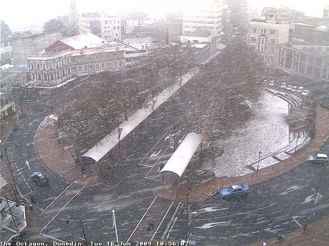
The
Dunedin Octagon webcam just snapped this really cold looking shot. Magic!
Re: Deepening low prediction/ cold outbreak Mid June
Posted: Tue 16/06/2009 11:05
by Razor
Theres definetely still a great deal of westerly componet here compared to previous events. It'll need a significant shift yet for us to see any prolonged action. Still clear blue skies to the west with scattered cumulus only. A line of showers out to sea and over to the eastern part of ChCh.
Re: Deepening low prediction/ cold outbreak Mid June
Posted: Tue 16/06/2009 11:05
by Janos
I hope gsvs at work...??
Lovely heavy shower on the peninsula now. Still very white ill upload some photos.
Re: Deepening low prediction/ cold outbreak Mid June
Posted: Tue 16/06/2009 11:14
by Storm Struck
That looks awesome in the Octagon there

.
Lastest radar doesnt pick these showers we had up much, but looks like a significant shower heading towards chch soon going by the 11am radar.
Re: Deepening low prediction/ cold outbreak Mid June
Posted: Tue 16/06/2009 11:36
by Razor
Looks like weatherwatch thinks the show is over for ChCh
The main band of snow clouds is moving across northern Canterbury bringing heavy sleet and hail showers but no reports of snow at this stage.
WeatherWatch believes if it hasn't snowed by noon the chances are far slimmer of snow this afternoon as the sun continues to warm things up and skies clear across Canterbury.
A secondary surge of snow showers is passing over coastal Otago currently however it isn't expected to affect Canterbury.
That last comment supports the idea there is far to much westerly in the system
Re: Deepening low prediction/ cold outbreak Mid June
Posted: Tue 16/06/2009 11:37
by gllitz
Move along folks...nothing to see here...move along....
Good stuff for Otago and Southland...great to hear/see/read about the snow down there...yet another disappointment for Canty...(then again, never WAS going to be anything for us in the first place!)
Perhaps this winter just isn't our year....once again...
Re: Deepening low prediction/ cold outbreak Mid June
Posted: Tue 16/06/2009 11:39
by Janos
Its been snowing heavily on and off for the last hour or so.
The Octagon image above shows just how heavy its been.
Re: Deepening low prediction/ cold outbreak Mid June
Posted: Tue 16/06/2009 11:39
by Razor
Stop complaining Glitz there was enough snow in ChCh last year for three years worth of fun.

Re: Deepening low prediction/ cold outbreak Mid June
Posted: Tue 16/06/2009 11:51
by jamie
gllitz wrote:Perhaps this winter just isn't our year....once again...
You Canty lot make me laugh.. 2006 massive dump, not too sure on 2007 and then 2008 you had snow fall after snowfall. AND its only June this year!!!!!
Re: Deepening low prediction/ cold outbreak Mid June
Posted: Tue 16/06/2009 11:54
by gllitz
j--me--h wrote:gllitz wrote:Perhaps this winter just isn't our year....once again...
You Canty lot make me laugh.. 2006 massive dump, not too sure on 2007 and then 2008 you had snow fall after snowfall. AND its only June this year!!!!!
0 for 3 (0 for 4?) so far this year is looking pretty bad, stats-wise....NOT a good start


(yes, we want snow, more snow, and then snow on top of that, thank you very much...

)
Re: Deepening low prediction/ cold outbreak Mid June
Posted: Tue 16/06/2009 12:01
by Janos
More snow showers/heavy heavy....
Re: Deepening low prediction/ cold outbreak Mid June
Posted: Tue 16/06/2009 12:20
by Janos
some of the heaviest showers are happening now big flakes and wind driven.
Re: Deepening low prediction/ cold outbreak Mid June
Posted: Tue 16/06/2009 12:22
by Janos
So heavy its settling again.
Re: Deepening low prediction/ cold outbreak Mid June
Posted: Tue 16/06/2009 13:18
by Razor
Its about time the metservice got with the picture and changed the ChCh forecast to fine, clear and cold with breezy SW, don't we think? Anyone see reason to differ?
Re: Deepening low prediction/ cold outbreak Mid June
Posted: Tue 16/06/2009 13:43
by Storm Struck
Does look still too SW with the showers offshore, really need the flow to go more southerly

.
Its only June first month of winter and from what ive heard July,August,September are going to be stormy months ahead which wouldnt be hard to believe at all.
In the meantime i hope those showers eventually decide to head onshore

Re: Deepening low prediction/ cold outbreak Mid June
Posted: Tue 16/06/2009 14:41
by mattyj46
southernthrash wrote:A light dusting of snow in Invercargill this morning, with a lot of black ice, the roads are certainly very slick.
Getting very cold outside, things have really started to freeze since 8am, and more light snow we get this morning won't be melting straight away, with more cloud rolling in off the sea.
It had already well starting freezing since 5.30am, the drive to work about 7km south of Invercargill was a very slow one, the roads were certainly slick, had to get some water to get the frozen snow of the back of the car
Re: Deepening low prediction/ cold outbreak Mid June
Posted: Tue 16/06/2009 15:00
by kiwisk8er
I feel insanely jealous and home sick. Wish I was back in Dunedin. We moved to Wellington three weeks ago and I knew that it would snow after I left. My family is emailing me and torturing me with their photo's of snow.
Oh and if you want to see lots of snow pics from Dunedin go here:
http://www.odt.co.nz/news/galleries/gal ... os-june-16
http://www.odt.co.nz/news/galleries/gal ... -16-part-2
Re: Deepening low prediction/ cold outbreak Mid June
Posted: Tue 16/06/2009 15:18
by southernthrash
mattyj46 wrote:southernthrash wrote:A light dusting of snow in Invercargill this morning, with a lot of black ice, the roads are certainly very slick.
Getting very cold outside, things have really started to freeze since 8am, and more light snow we get this morning won't be melting straight away, with more cloud rolling in off the sea.
It had already well starting freezing since 5.30am, the drive to work about 7km south of Invercargill was a very slow one, the roads were certainly slick, had to get some water to get the frozen snow of the back of the car
Interesting, I was up and about from 6 am, where I am it was still relatively wet early on, with a few light snow showers around 7 am, after which it really started to get cold. Areas around the house/yard that have been in the shade all day are still well iced up, a tiny little patch of snow left on the lawn now.
Looking across the plains to the hills from the second storey of our house, it certainly looks as though Invercargill missed most of the precip., which is often the case in these events.
Re: Deepening low prediction/ cold outbreak Mid June
Posted: Tue 16/06/2009 15:21
by tich
Wellington doesn't look to be far from snow this afternoon, according to obs; Rimutaka Rd has already been closed. Trademe posters reported snow falling in Masterton and sleet in Dannevirke in recent hours.
Sun is shining in central Chch now, with showers (snow, hail and sleet probably) continuing on BP.
Re: Deepening low prediction/ cold outbreak Mid June
Posted: Tue 16/06/2009 15:30
by RWood
There was a light shower or two of graupel but now some breaks in the cloud and I wouldn't be surprised if there is very little further precipitation in the city and main suburbs. With these very cold SSW outbreaks there usually isn't much. May be quite a different story in northern Hutt and beyond.
Re: Deepening low prediction/ cold outbreak Mid June
Posted: Tue 16/06/2009 15:33
by Janos
Still getting the odd snow shower. Lawns are still white although a thaw has definately started.
Will try to upload some photos.
Re: Deepening low prediction/ cold outbreak Mid June
Posted: Tue 16/06/2009 15:57
by Shepherds Valley WX
RWood is correct for Upper/Northern Hutt Valley - we have had light snowfall here in the hills above Pinehaven (Elev 135m ASL). Some flakes settled briefly on the ground. Temp is a cool 2.5C, with a very light NW. Weather Display on the WX Station PC reports snowfall as well.
Re: Deepening low prediction/ cold outbreak Mid June
Posted: Tue 16/06/2009 17:29
by mattyj46
southernthrash wrote:A light dusting of snow in Invercargill this morning, with a lot of black ice, the roads are certainly very slick.
Getting very cold outside, things have really started to freeze since 8am, and more light snow we get this morning won't be melting straight away, with more cloud rolling in off the sea.
Some places were worse than others, down South Invercargillish way (near Verdon College) it was very slippery, but then get onto the open road and its not so, still had to drive 60km/h though.
Yep it looks like we missed a whole heap of

as you said it is often the case in these events unfortunantly.
Re: Deepening low prediction/ cold outbreak Mid June
Posted: Tue 16/06/2009 17:36
by NZstorm
southernthrash wrote
it certainly looks as though Invercargill missed most of the precip., which is often the case in these events.
Stewart Island has a major sheltering effect on Invercargill in SW flows and I'm sure thats part of the reason why the city gets less snowfall than eastern areas.