Canterbury Thunderstorms - 14th December 2009
Forum rules
These topics are a read-only archive and may be subject to out-of-date information.
For today's weather discussion head to: New Zealand Weather & Climate
These topics are a read-only archive and may be subject to out-of-date information.
For today's weather discussion head to: New Zealand Weather & Climate
-
NZstorm

- Posts: 11333
- Joined: Mon 10/03/2003 19:38
- Location: Grey Lynn, Auckland
- Has thanked: 342 times
- Been thanked: 361 times
Re: Canterbury Thunderstorms - 14th December 2009
I think on the day there was two zones of convergence, the typical northeasterly vs westerly running down the length of Canterbury with a SE change coming up. I think the junction of these two zones of convergence would have been an area of enhanced lift and I reckon this is where the largest hail and also the Methven tornado occured. The model guidance for this event was excellent.
-
Weather Watcher
- MetService Meteorologist
- Posts: 283
- Joined: Sat 15/03/2003 10:59
- Location: Upper Hutt, NZ
- Has thanked: 3 times
- Been thanked: 0
Re: Canterbury Thunderstorms - 14th December 2009
Radar imagery shows the Methven tornado was around 4pm.
-
Nev

- Moderator
- Posts: 6229
- Joined: Tue 07/03/2006 15:24
- Location: Waiheke Island, Hauraki Gulf
- Has thanked: 474 times
- Been thanked: 1073 times
Re: Canterbury Thunderstorms - 14th December 2009
Cool,  thanks Weather Watcher.
Here's a link to MetVUW's 4pm Chch radar-image (and google-map of Methven).
Here's a link to MetVUW's 4pm Chch radar-image (and google-map of Methven).
-
Thunder
- Posts: 2068
- Joined: Wed 12/03/2003 19:47
- Location: Mt Somers
- Has thanked: 19 times
- Been thanked: 41 times
Re: Canterbury Thunderstorms - 14th December 2009
4pm, hmm. Cool. Man we could've made that, we left Hororata at around 3pm initially to then go through the Rakaia Gorge towards Methven way to catch up with the second line we could see way in the distance (confirmed on steve's cellphone when we looked at the radar (through this forum) the line would've been just north of the Rangitata river at this point). Then we got the news from Ben saying of the funnel in springfield so we turned back. Dammit! lol, Oh well.... Considering this information perhaps even if we had laptops and all the mobile data in the world we would've still gone back towards sheffield way, maybe better understanding of likely tornado producing areas is key. For e.g. that second line that produced the gust front was the line that produced the tornado a bit earlier, so as NZstorm says it would've been the combination of varying winds that helped whereas the first cell we were on it was blowing NE even after it passed through. No doubt some form of convergence but not the main kicker.
Soo to get tornadoes the line or cloud your sitting under really has to be the one with the change backing it up, not the pre frontal storms while potentially they may deliever funnels they probably won't produce anything dramatic. That was the case with the 27th October 2002 storm in Tai Tapu I'm pretty sure aswell anyway, it went southerly fairly quickly behind that particular cloud.
Soo to get tornadoes the line or cloud your sitting under really has to be the one with the change backing it up, not the pre frontal storms while potentially they may deliever funnels they probably won't produce anything dramatic. That was the case with the 27th October 2002 storm in Tai Tapu I'm pretty sure aswell anyway, it went southerly fairly quickly behind that particular cloud.

Aaron Wilkinson
-
03Stormchaser

- Moderator
- Posts: 4428
- Joined: Tue 09/12/2003 12:11
- Location: Prebbleton
- Has thanked: 104 times
- Been thanked: 184 times
- Contact:
Re: Canterbury Thunderstorms - 14th December 2009
Awesome modis sat image from monday, to be viewed in 250m per pixel! 
http://rapidfire.sci.gsfc.nasa.gov/real ... 0.250m.jpg
http://rapidfire.sci.gsfc.nasa.gov/real ... 0.250m.jpg
NZ Largest Storm Chasing Facebook Pagehttp://www.facebook.com/nzstormchasers
NZ Largest Storm Chase Community https://www.facebook.com/groups/NZStormchasersGroup
NZ Stormchasers TV https://www.youtube.com/@NZStormchasers
NZ Largest Storm Chase Community https://www.facebook.com/groups/NZStormchasersGroup
NZ Stormchasers TV https://www.youtube.com/@NZStormchasers
-
Manukau heads obs
- Posts: 12305
- Joined: Mon 10/03/2003 16:30
- Location: West Coast Road, Manukau Peninsula, North Island
- Has thanked: 0
- Been thanked: 0
- Contact:
Re: Canterbury Thunderstorms - 14th December 2009
thats chasing for you, and part of the challenge, trying to know which cell to chase ! 
love that high res sat image
especially all the coastal cu cloud lines
love that high res sat image
especially all the coastal cu cloud lines

-
mikestormchaser
- Posts: 2711
- Joined: Sat 03/06/2006 20:11
- Location: Rolleston, Canterbury
- Has thanked: 355 times
- Been thanked: 607 times
Re: Canterbury Thunderstorms - 14th December 2009
Its an absolute monster steve that CB showen on that sat loop.. great shot there03Stormchaser wrote:Awesome modis sat image from monday, to be viewed in 250m per pixel!
http://rapidfire.sci.gsfc.nasa.gov/real ... 0.250m.jpg
Mike
Stormchasers.co.nz
Stormchasers.co.nz
-
03Stormchaser
- Moderator
- Posts: 4428
- Joined: Tue 09/12/2003 12:11
- Location: Prebbleton
- Has thanked: 104 times
- Been thanked: 184 times
- Contact:
Re: Canterbury Thunderstorms - 14th December 2009
It shows the 2 separate cells, the one to the north that produced Ben's funnel and the one to the south that had the methven tornado, Aaron and myself were stuck some were in the middle!!
NZ Largest Storm Chasing Facebook Pagehttp://www.facebook.com/nzstormchasers
NZ Largest Storm Chase Community https://www.facebook.com/groups/NZStormchasersGroup
NZ Stormchasers TV https://www.youtube.com/@NZStormchasers
NZ Largest Storm Chase Community https://www.facebook.com/groups/NZStormchasersGroup
NZ Stormchasers TV https://www.youtube.com/@NZStormchasers
-
trickytiger
- Posts: 334
- Joined: Sat 05/07/2008 10:36
- Location: Timaru, New Zealand. 13m asl
- Has thanked: 1 time
- Been thanked: 27 times
Re: Canterbury Thunderstorms - 14th December 2009
Have uploaded some photo's and video's my mate took.
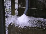
Overflowing out the gutter
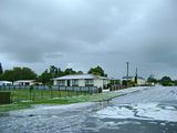
Usual bit of water on Alexandria Street (happens with lots of rain or too much hail)
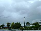
Looking East out towards the sea
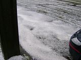

First lot of hail when it first started was almost twice this size
Have got more pics in the album of the hail at: http://s12.photobucket.com/albums/a244/ ... hailstorm/
Video Links:
http://www.youtube.com/watch?v=HX19tPcppRw
http://www.youtube.com/watch?v=mAuN-9r_jkQ
-
DT-NZ

- Posts: 1010
- Joined: Mon 09/02/2009 10:55
- Location: Northland, NZ
- Has thanked: 0
- Been thanked: 0
Re: Canterbury Thunderstorms - 14th December 2009
Awesome ticky, thank's for uploading these photo's and links . I appreciated looking at them all, what a storm that was!!! I still think about it... powerful stuff.trickytiger wrote:Have uploaded some photo's and video's my mate took.
Lightning in NZ
The right terminology lends a hint as to the nature of the different forms.
A Vertigo Quote.
The right terminology lends a hint as to the nature of the different forms.
A Vertigo Quote.
-
DT-NZ
- Posts: 1010
- Joined: Mon 09/02/2009 10:55
- Location: Northland, NZ
- Has thanked: 0
- Been thanked: 0
Re: Canterbury Thunderstorms - 14th December 2009
I think some of the post's are missing from this thread? I was wanted to re-read this storm event and look at all the fantastic storm images... but, they have all gone... now there are only 2 pages in total with 27 posts...
Oh, well... that's ok... perhaps it's the board gremlins... or summin like that...
Oh, well... that's ok... perhaps it's the board gremlins... or summin like that...
Lightning in NZ
The right terminology lends a hint as to the nature of the different forms.
A Vertigo Quote.
The right terminology lends a hint as to the nature of the different forms.
A Vertigo Quote.
-
03Stormchaser
- Moderator
- Posts: 4428
- Joined: Tue 09/12/2003 12:11
- Location: Prebbleton
- Has thanked: 104 times
- Been thanked: 184 times
- Contact:
Re: Canterbury Thunderstorms - 14th December 2009
Not sure what you have got going on there, I can see 9 pages and 212 posts!!DT-NZ wrote:I think some of the post's are missing from this thread? I was wanting to re-read storm event and look at all the fantastic storm images... but, they have all gone... and there are only 2 pages in total with 27 posts...
Oh, well... that's ok...
NZ Largest Storm Chasing Facebook Pagehttp://www.facebook.com/nzstormchasers
NZ Largest Storm Chase Community https://www.facebook.com/groups/NZStormchasersGroup
NZ Stormchasers TV https://www.youtube.com/@NZStormchasers
NZ Largest Storm Chase Community https://www.facebook.com/groups/NZStormchasersGroup
NZ Stormchasers TV https://www.youtube.com/@NZStormchasers
-
DT-NZ
- Posts: 1010
- Joined: Mon 09/02/2009 10:55
- Location: Northland, NZ
- Has thanked: 0
- Been thanked: 0
Re: Canterbury Thunderstorms - 14th December 2009
Hi ya 03Stormchaser03Stormchaser wrote:Not sure what you have got going on there, I can see 9 pages and 212 posts!!DT-NZ wrote:I think some of the post's are missing from this thread? I was wanting to re-read storm event and look at all the fantastic storm images... but, they have all gone... and there are only 2 pages in total with 27 posts...
Oh, well... that's ok...
You do not have the required permissions to view the files attached to this post.
Lightning in NZ
The right terminology lends a hint as to the nature of the different forms.
A Vertigo Quote.
The right terminology lends a hint as to the nature of the different forms.
A Vertigo Quote.
-
Nev
- Moderator
- Posts: 6229
- Joined: Tue 07/03/2006 15:24
- Location: Waiheke Island, Hauraki Gulf
- Has thanked: 474 times
- Been thanked: 1073 times
Re: Canterbury Thunderstorms - 14th December 2009
Sounds weird. 
I can also see all 9 pages of this thread, with this being post #214, so can't really help either.
Perhaps Foggy or some of the more tech-minded here may have a few clues.
I can also see all 9 pages of this thread, with this being post #214, so can't really help either.
Perhaps Foggy or some of the more tech-minded here may have a few clues.
-
DT-NZ
- Posts: 1010
- Joined: Mon 09/02/2009 10:55
- Location: Northland, NZ
- Has thanked: 0
- Been thanked: 0
Re: Canterbury Thunderstorms - 14th December 2009
Thank's Nev - I've rebooted my comp, logged on again and I am still seeing the same thing, it is wierd... what I noticed though which I will mention is when I am not logged on I can read all the pages in this thread normally - very unusual.Nev wrote:Sounds weird.
I can also see all 9 pages of this thread, with this being post #214, so can't really help either.
Perhaps Foggy or some of the more tech-minded here may have a few clues.
Lightning in NZ
The right terminology lends a hint as to the nature of the different forms.
A Vertigo Quote.
The right terminology lends a hint as to the nature of the different forms.
A Vertigo Quote.