
High Risk of Thunderstorms - SI, Sunday 10 January
Forum rules
These topics are a read-only archive and may be subject to out-of-date information.
For today's weather discussion head to: New Zealand Weather & Climate
These topics are a read-only archive and may be subject to out-of-date information.
For today's weather discussion head to: New Zealand Weather & Climate
-
Captain Salty

- Posts: 289
- Joined: Sat 26/12/2009 12:59
- Location: Sydenham, ChCh
- Has thanked: 14 times
- Been thanked: 15 times
-
gllitz

- Posts: 1335
- Joined: Wed 04/01/2006 11:45
- Location: Perth, Western Australia
- Has thanked: 0
- Been thanked: 0
Re: High Risk of Thunderstorms - SI, Sunday 10 January
Good luck, guys!!Andrew Massie wrote:On the road now. Me, Aaron and Mike Placed ourselves just nw of rakaia. Strange clouds appearing to come out of the ground at thunderstorm corner! Waiting patiently! Would some nice person post a 3pm radar image here for us please?!! Cheers! Andrew on the road!
"Saru mo ki kara ochiru"
-
Weetbicks

- Posts: 586
- Joined: Mon 12/10/2009 19:14
- Location: Christchurch
- Has thanked: 0
- Been thanked: 0
Re: High Risk of Thunderstorms - SI, Sunday 10 January
I'm thinking I might head out later on somewhere and find a good view to the south, see what I can see and snap a pic of two, probably just out near the airport.
-
MoorfNZ

- Posts: 506
- Joined: Sat 30/05/2009 23:55
- Location: (300m asl) Waddington, inland mid-Canterbury, New Zealand
- Has thanked: 4 times
- Been thanked: 3 times
Re: High Risk of Thunderstorms - SI, Sunday 10 January
Now back and up in tower waiting for any requests or obs ... Kings of Leon blasting... hot coffee... full pack of fags... I'm ready.. bring it on!!! 
Returning home half an hour ago temp in Rolleston was 18 and by time back home here in Wadders it was 21deg. Currently 20degs. Nor'wester still blowing but not as hard as earlier...
Returning home half an hour ago temp in Rolleston was 18 and by time back home here in Wadders it was 21deg. Currently 20degs. Nor'wester still blowing but not as hard as earlier...
-
MoorfNZ
- Posts: 506
- Joined: Sat 30/05/2009 23:55
- Location: (300m asl) Waddington, inland mid-Canterbury, New Zealand
- Has thanked: 4 times
- Been thanked: 3 times
Re: High Risk of Thunderstorms - SI, Sunday 10 January
Hey there Cap'n Salty - was also checking out the StormVue images via SkyWatcher - interesting stuff...
-
MoorfNZ
- Posts: 506
- Joined: Sat 30/05/2009 23:55
- Location: (300m asl) Waddington, inland mid-Canterbury, New Zealand
- Has thanked: 4 times
- Been thanked: 3 times
Re: High Risk of Thunderstorms - SI, Sunday 10 January
Why are the St. Albans (http://weather.stalbans.net.nz/wx9.html) and SkyWatcher (http://skywatcher.net.nz/) strike maps showing vastly different strike data?? Their clocks are about 10min difference but not enough to warrant such vast differences in numbers? Anyone?
-
Weetbicks
- Posts: 586
- Joined: Mon 12/10/2009 19:14
- Location: Christchurch
- Has thanked: 0
- Been thanked: 0
Re: High Risk of Thunderstorms - SI, Sunday 10 January
3:30pm rain radar on sky digital shows the area of highest intensity is right over Timaru.
..
3:45pm rain radar shows the frontal band is still around the Timaru area, hmm seems to be moving slowly?
..
3:45pm rain radar shows the frontal band is still around the Timaru area, hmm seems to be moving slowly?
Last edited by Weetbicks on Sun 10/01/2010 15:55, edited 1 time in total.
-
Captain Salty
- Posts: 289
- Joined: Sat 26/12/2009 12:59
- Location: Sydenham, ChCh
- Has thanked: 14 times
- Been thanked: 15 times
Re: High Risk of Thunderstorms - SI, Sunday 10 January
Hi there, i was wondering too. I guess they're not that accurate, what are they exactly, some sort of radio receiver?MoorfNZ wrote:Why are the St. Albans (http://weather.stalbans.net.nz/wx9.html) and SkyWatcher (http://skywatcher.net.nz/) strike maps showing vastly different strike data?? Their clocks are about 10min difference but not enough to warrant such vast differences in numbers? Anyone?
-
MoorfNZ
- Posts: 506
- Joined: Sat 30/05/2009 23:55
- Location: (300m asl) Waddington, inland mid-Canterbury, New Zealand
- Has thanked: 4 times
- Been thanked: 3 times
Re: High Risk of Thunderstorms - SI, Sunday 10 January
Raining in Ashburton with southerly wind picking up
-
MoorfNZ
- Posts: 506
- Joined: Sat 30/05/2009 23:55
- Location: (300m asl) Waddington, inland mid-Canterbury, New Zealand
- Has thanked: 4 times
- Been thanked: 3 times
Re: High Risk of Thunderstorms - SI, Sunday 10 January
AFAIK, they are relayed from individual lightning detectors - personal and corporate - but perhaps someone else can expand on that. Certainly the reporting seems somewhat out of sync which would indicate, to me, a collection of individual data being collected.Captain Salty wrote:Hi there, i was wondering too. I guess they're not that accurate, what are they exactly, some sort of radio receiver?MoorfNZ wrote:Why are the St. Albans (http://weather.stalbans.net.nz/wx9.html) and SkyWatcher (http://skywatcher.net.nz/) strike maps showing vastly different strike data?? Their clocks are about 10min difference but not enough to warrant such vast differences in numbers? Anyone?
-
Captain Salty
- Posts: 289
- Joined: Sat 26/12/2009 12:59
- Location: Sydenham, ChCh
- Has thanked: 14 times
- Been thanked: 15 times
-
Weetbicks
- Posts: 586
- Joined: Mon 12/10/2009 19:14
- Location: Christchurch
- Has thanked: 0
- Been thanked: 0
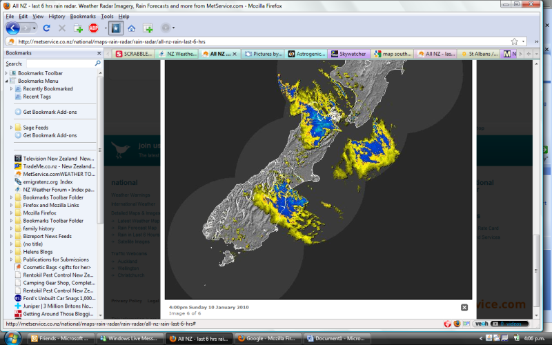
Re: High Risk of Thunderstorms - SI, Sunday 10 January
4pm radar
You do not have the required permissions to view the files attached to this post.
-
Weetbicks
- Posts: 586
- Joined: Mon 12/10/2009 19:14
- Location: Christchurch
- Has thanked: 0
- Been thanked: 0
Re: High Risk of Thunderstorms - SI, Sunday 10 January
That live camera on the Timaru site is awesome
-
snowstormwatcher

- Posts: 1643
- Joined: Wed 23/09/2009 09:45
- Location: South Canterbury. 20km inland from Timaru.
- Has thanked: 188 times
- Been thanked: 138 times
Re: High Risk of Thunderstorms - SI, Sunday 10 January
Pouring down here 7mm in the last 40 minutes 10 degrees lightning strikes on the storm tracker around fox peak area but i havent seen anything here yet.
-
Kelly_Cattermole
- Posts: 46
- Joined: Thu 08/10/2009 19:46
- Location: Kirwee (179m)
- Has thanked: 0
- Been thanked: 0
Re: High Risk of Thunderstorms - SI, Sunday 10 January
Looking quite nice, its like waking up xmas morning and waiting to open your presents!, oh crud, id better go cover whats left of the grapes!
-
Nev

- Moderator
- Posts: 6231
- Joined: Tue 07/03/2006 15:24
- Location: Waiheke Island, Hauraki Gulf
- Has thanked: 474 times
- Been thanked: 1074 times
Re: High Risk of Thunderstorms - SI, Sunday 10 January
The St Albans detector looks a bit dodgy, i.e. I don't think it's able to judge distance very well. Whereas Steven Graham's detector (skywatcher) is correlated with other detectors around the country and so is able to triangulate distance far more accurately.MoorfNZ wrote:Why are the St. Albans (http://weather.stalbans.net.nz/wx9.html) and SkyWatcher (http://skywatcher.net.nz/) strike maps showing vastly different strike data?? Their clocks are about 10min difference but not enough to warrant such vast differences in numbers? Anyone?
-
Andrew Massie
- Posts: 1032
- Joined: Fri 10/03/2006 14:03
- Has thanked: 0
- Been thanked: 0
Re: High Risk of Thunderstorms - SI, Sunday 10 January
Thanks you guys! Unfortunately, i can't view.. Wierd. Has turned southerly here, cold but no rain or action aarghMoorfNZ wrote:4pm Rain Radar for you guys on the road...
-
MoorfNZ
- Posts: 506
- Joined: Sat 30/05/2009 23:55
- Location: (300m asl) Waddington, inland mid-Canterbury, New Zealand
- Has thanked: 4 times
- Been thanked: 3 times
Re: High Risk of Thunderstorms - SI, Sunday 10 January
Thanks Nev, I'll keep Graham's up on the screen then.
Temp is dropping here very noticeably, dark cloud puffing up over the Alps towards TC corner. Wind dropped and I suspect will change round from NW to S shortly. Not long now if any event is going to happen.
Any word from the boys on the road?
Temp is dropping here very noticeably, dark cloud puffing up over the Alps towards TC corner. Wind dropped and I suspect will change round from NW to S shortly. Not long now if any event is going to happen.
Any word from the boys on the road?
-
MoorfNZ
- Posts: 506
- Joined: Sat 30/05/2009 23:55
- Location: (300m asl) Waddington, inland mid-Canterbury, New Zealand
- Has thanked: 4 times
- Been thanked: 3 times
Re: High Risk of Thunderstorms - SI, Sunday 10 January
Andrew - if you're still around Rakaia area you shouldn't have long to wait for some action...
-
Kelly_Cattermole
- Posts: 46
- Joined: Thu 08/10/2009 19:46
- Location: Kirwee (179m)
- Has thanked: 0
- Been thanked: 0
Re: High Risk of Thunderstorms - SI, Sunday 10 January
Can see some low lying southerly cloud moving up the plains from Kirwee atm, wind just changed to southerly
-
snowstormwatcher
- Posts: 1643
- Joined: Wed 23/09/2009 09:45
- Location: South Canterbury. 20km inland from Timaru.
- Has thanked: 188 times
- Been thanked: 138 times
Re: High Risk of Thunderstorms - SI, Sunday 10 January
Dropped back to 8 degrees now 10mm of rain from this event so far.
You do not have the required permissions to view the files attached to this post.
-
Lawrence

- Posts: 958
- Joined: Mon 25/06/2007 09:11
- Location: Kirwee,Selwyn,Canterbury,157m ASL
- Has thanked: 169 times
- Been thanked: 68 times
Re: High Risk of Thunderstorms - SI, Sunday 10 January
Clouds seem to be starting to move here,wind has just picked up to,looking dark and ominous 
-
MoorfNZ
- Posts: 506
- Joined: Sat 30/05/2009 23:55
- Location: (300m asl) Waddington, inland mid-Canterbury, New Zealand
- Has thanked: 4 times
- Been thanked: 3 times
Re: High Risk of Thunderstorms - SI, Sunday 10 January
V. dark over Alps towards SW, I can smell rain...
Big change to southerly in clouds - moving fast, too and now gusting from south...
Big change to southerly in clouds - moving fast, too and now gusting from south...