
I see Met service have a thunderstorm watch up for eastern areas for heavy rainfall this afternoon.
The gfs has a forecast lifted index of -4.4 for Gisborne but the 500mb wind is 10kts. That makes for very slow moving pulse cb's.
Convective Outlook Mid January- North Island
Forum rules
These topics are a read-only archive and may be subject to out-of-date information.
For today's weather discussion head to: New Zealand Weather & Climate
These topics are a read-only archive and may be subject to out-of-date information.
For today's weather discussion head to: New Zealand Weather & Climate
-
jamie
- Posts: 5907
- Joined: Fri 25/02/2011 21:35
- Location: Hamilton NZ
- Has thanked: 22 times
- Been thanked: 273 times
- Contact:
Re: Convective Outlook Mid January- North Island
Interesting this, as i just reviewd all the lightning data from last night and sure enough the storm i hear here at 11.30 moved over hamilton. In all it has been an active couple of days and very much enjoyedLightning strike hits Hamilton water supply
NZPA
A lightning strike at Hamilton's water treatment plant has affected water supply in parts of the city.
The lightning strike happened about midnight, damaging computers and alarm systems at the Peacockes Rd plant, which provides all of the city's fresh water supply.
City Waters manager Tim Harty said this had affected water to the city and some residents were experiencing low pressure, and in extreme cases, a total loss of water supply. Residents in Hillcrest and Flagstaff areas were particularly affected.
"We are currently bringing the plant back on line, but having lost all power and communication, this takes some time," said Mr Harty.
Council water engineers were assessing the damage, and were checking reservoirs and pump stations. It was hoped supplies will be restored later this morning.
Damaged alarm systems meant council staff were locked out, and had to break in to gain access this morning.
-
Vertigo

- Posts: 1184
- Joined: Sun 09/12/2007 23:50
- Location: Henderson, Auckland
- Has thanked: 0
- Been thanked: 12 times
Re: Convective Outlook Mid January- North Island
thunderstorms currently firing up over whakatane area and out to sea. i see metservice picks a high risk of severe thunderstorms, no doubt related to the slow motion of the storms. would be nice to be down there today.
-
Tornado Tim

- Moderator
- Posts: 4920
- Joined: Sun 19/10/2008 17:17
- Location: Raglan, Waikato / Hillcrest, Hamilton
- Has thanked: 102 times
- Been thanked: 202 times
- Contact:
Re: Convective Outlook Mid January- North Island
Is this a false colour on the radar? Its pink/purple, the highest on the radar scale?
You do not have the required permissions to view the files attached to this post.
NZAPStrike.net - NZ Aus Pacific Strike Network
-
tgsnoopy

- Posts: 3655
- Joined: Fri 25/03/2005 21:17
- Location: Tauranga, NZ (Curse you COVID-19 :-( )
- Has thanked: 817 times
- Been thanked: 283 times
Re: Convective Outlook Mid January- North Island
Not a lot to report from Whakatane. I'm working in various wards doing some annual's. Obviously I'm keeping a watch out, but the occasional showers aren't heavy, now low cloud, high humidity, otherwise boring.
-
Tornado Tim
- Moderator
- Posts: 4920
- Joined: Sun 19/10/2008 17:17
- Location: Raglan, Waikato / Hillcrest, Hamilton
- Has thanked: 102 times
- Been thanked: 202 times
- Contact:
Re: Convective Outlook Mid January- North Island
Even though M/s have posted no risk for Waikato I still think its quite possible for things to get going.
NZAPStrike.net - NZ Aus Pacific Strike Network
-
spwill
- Posts: 9932
- Joined: Sun 29/06/2003 22:39
- Location: Mt Eden Auckland
- Has thanked: 870 times
- Been thanked: 876 times
Re: Convective Outlook Mid January- North Island
Lightning active Cb clouds on the eastern side of the Ranges, slow moving on the Mahia radar, must be some good rain dumps over the Mnts currentlyNot a lot to report from Whakatane
Re: Convective Outlook Mid January- North Island
I don't see how Waikato will kick off today when they are stuck in a showery southwesterly, and the upper flow looks pretty flat.
-
Tornado Tim
- Moderator
- Posts: 4920
- Joined: Sun 19/10/2008 17:17
- Location: Raglan, Waikato / Hillcrest, Hamilton
- Has thanked: 102 times
- Been thanked: 202 times
- Contact:
Re: Convective Outlook Mid January- North Island
It looked better at 1 PM, now all the showers have fibrous tops on them, arggg!
NZAPStrike.net - NZ Aus Pacific Strike Network
-
Chris Raine
- Posts: 952
- Joined: Thu 17/04/2003 11:54
- Location: Thornbury
- Has thanked: 11 times
- Been thanked: 69 times
Re: Convective Outlook Mid January- North Island
Severe thunderstorm warning issued for Napier Hastings
SEVERE THUNDERSTORM WARNING
TOP PRIORITY FOR IMMEDIATE BROADCAST
Issued by MetService at 04:10 pm Friday 22 January 2010.
Valid until 05:00 pm Friday 22 January 2010.
This warning affects people in the following local government areas:
HASTINGS and NAPIER.
At 04:00 pm, MetService weather radar detected severe thunderstorms near NAPIER, ESKDALE, RISSINGTON, HASTINGS, FERNHILL, BRIDGE PA and PAKIPAKI.
These severe thunderstorms are moving towards the northwest, and are expected to lie near NAPIER, ESKDALE, RISSINGTON, HASTINGS, FERNHILL, BRIDGE PA and PAKIPAKI at 04:30 pm and near NAPIER, ESKDALE, RISSINGTON, HASTINGS, FERNHILL, BRIDGE PA, MARAEKAKAHO and PAKIPAKI at 05:00 pm.
These thunderstorms are expected to be accompanied by torrential rain.
Torrential rain can cause surface and/or flash flooding about streams, gullies and urban areas, and make driving conditions extremely hazardous.
Very heavy rain associated with this storm has been reported earlier from MAHIA RADAR.
A Severe Thunderstorm Watch remains in force for GISBORNE and HAWKES BAY
-
CHCH Weather Chaser

- Posts: 3460
- Joined: Thu 26/06/2008 16:10
- Location: Halswell / Hoon Hay Christchurch
- Has thanked: 0
- Been thanked: 0
Re: Convective Outlook Mid January- North Island
I see 27.8mm in the last hour in Napier!!!
Reporting Live from Southern Christchurch
Leighton Thomas
2014 Rainfall: Jan: 21mm Feb: 76mm March: 170mm April: 201mm YTD: 468mm
Leighton Thomas
2014 Rainfall: Jan: 21mm Feb: 76mm March: 170mm April: 201mm YTD: 468mm
-
kelhb

- Posts: 50
- Joined: Fri 22/01/2010 16:36
- Location: Hastings, Hawkes Bay
- Has thanked: 0
- Been thanked: 0
Re: Convective Outlook Mid January- North Island
Hi Guys!
Another newbie here. Im in Hastings and the Metservice forcasted storms arrived right on schedule. I took a drive up Temata Peak around 3pm and took some photos of the approaching storm. When we came back down, decided to head out on one of the back rounds and watch abit more, saw a few beautiful cg strikes but unfortunately wasnt quick enough off the mark to get any photos
The rain that came with it was definitely heavy, we had to pull over as even with wipers going full steam they couldnt deal with the deluge.
Theres still the odd rumble but its mostly quiet now.
Has been an awesome afternoon!
-
jrj
- Posts: 462
- Joined: Tue 18/03/2003 18:00
- Location: Havelock North, New Zealand
- Has thanked: 0
- Been thanked: 0
Re: Convective Outlook Mid January- North Island
10 minute deluge in Havelock North, 7mm. 
Not good for Hayley Westenra concert tonight
Not good for Hayley Westenra concert tonight
-
DT-NZ

- Posts: 1010
- Joined: Mon 09/02/2009 10:55
- Location: Northland, NZ
- Has thanked: 0
- Been thanked: 0
Re: Convective Outlook Mid January- North Island
Hi kelhbkelhb wrote:Hi Guys!
Another newbie here. Im in Hastings and the Metservice forcasted storms arrived right on schedule. I took a drive up Temata Peak around 3pm and took some photos of the approaching storm. When we came back down, decided to head out on one of the back rounds and watch abit more, saw a few beautiful cg strikes but unfortunately wasnt quick enough off the mark to get any photos
The rain that came with it was definitely heavy, we had to pull over as even with wipers going full steam they couldnt deal with the deluge.
Theres still the odd rumble but its mostly quiet now.
Has been an awesome afternoon!
Welcome to the NZWF - great reading your report!!! look forward to seeing some pic's, Awesome
Lightning in NZ
The right terminology lends a hint as to the nature of the different forms.
A Vertigo Quote.
The right terminology lends a hint as to the nature of the different forms.
A Vertigo Quote.
-
Michael

- Posts: 7210
- Joined: Thu 27/03/2003 12:04
- Location: Rainy Manurewa, Auckland - "City of Gales"
- Has thanked: 0
- Been thanked: 1 time
- Contact:
Re: Convective Outlook Mid January- North Island
Had a funnel tornado on tv in the manawatu disappeard back into the cloud,not sure which part,perhaps Gregg W may know,also heavy flooding in Flaxmare Hastings,better than Jims bumbling on the weather report tonight
Re: Convective Outlook Mid January- North Island
21 knots is not a gale.Michael wrote:Just like Spring here,showers and Gales.
-
NZ Thunderstorm Soc
- Posts: 18527
- Joined: Wed 12/03/2003 22:08
- Location: Raukapuka Geraldine
- Has thanked: 1781 times
- Been thanked: 1429 times
Re: Convective Outlook Mid January- North Island
Myself wrote:
21 knots is not a gale.
It is around Micheal's place. You should know that, especially from the SW
JohnGaul
NZThS
JohnGaul
NZThS
NZThS
-
Tornado Tim
- Moderator
- Posts: 4920
- Joined: Sun 19/10/2008 17:17
- Location: Raglan, Waikato / Hillcrest, Hamilton
- Has thanked: 102 times
- Been thanked: 202 times
- Contact:
Re: Convective Outlook Mid January- North Island
LOL hahahaha!NZ Thunderstorm Soc wrote: It is around Micheal's place. You should know that, especially from the SW
JohnGaul
NZThS
Oh btw Micheal,
Did you find the broom to sweep up the pine needles?
NZAPStrike.net - NZ Aus Pacific Strike Network
-
Michael
- Posts: 7210
- Joined: Thu 27/03/2003 12:04
- Location: Rainy Manurewa, Auckland - "City of Gales"
- Has thanked: 0
- Been thanked: 1 time
- Contact:
Re: Convective Outlook Mid January- North Island
Na not today just left them,theyll all be back tomorrow,the low has stalled to the east. 
Tornado Tim wrote:LOL hahahaha!NZ Thunderstorm Soc wrote: It is around Micheal's place. You should know that, especially from the SW
JohnGaul
NZThS
Oh btw Micheal,
Did you find the broom to sweep up the pine needles?
-
Andrew Massie
- Posts: 1032
- Joined: Fri 10/03/2006 14:03
- Has thanked: 0
- Been thanked: 0
Re: Convective Outlook Mid January- North Island
LMAO!! That's the spirit I love to see round here..!
-
tgsnoopy
- Posts: 3655
- Joined: Fri 25/03/2005 21:17
- Location: Tauranga, NZ (Curse you COVID-19 :-( )
- Has thanked: 817 times
- Been thanked: 283 times
Re: Convective Outlook Mid January- North Island
It did go off this afternoon around Whakatane, started firing up about 1.45pm, I actually managed to see a decent CG out the window at one stage. Lots of thunder even stuck inside working it was cleary audible.
In Hindsight I wish I could have gone chasing.
In Hindsight I wish I could have gone chasing.
Re: Convective Outlook Mid January- North Island
I was out by Fernhill just after 3pm today as the storms approached, was very impressive as the very low cloud started to cover the plains. Didn't have the camera with me though
I took this looking towards Hastings around 5pm as things started to clear a bit
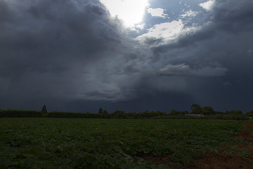
I took this looking towards Hastings around 5pm as things started to clear a bit
-
GreggWard
- Posts: 434
- Joined: Wed 12/03/2003 22:09
- Location: Palmerston North
- Has thanked: 160 times
- Been thanked: 5 times
Re: Convective Outlook Mid January- North Island
I'm not sure either Michael. We had thunderstorms to the SW of Palmerston North, yesterday and to the E of Palmerston North today. If I find out any more info, I will let you know.Michael wrote:Had a funnel tornado on tv in the manawatu disappeard back into the cloud,not sure which part,perhaps Gregg W may know
-
Achten
- Posts: 141
- Joined: Thu 20/03/2003 20:57
- Location: Hawkes Bay
- Has thanked: 0
- Been thanked: 19 times
- Contact:
Re: Convective Outlook Mid January- North Island
62mm in the gauge this morning. Yesterday started off with frequent storm activity from latest afternoon to early evening then rain continued on. The storms were impressive early on as I left work in central Hastings with some beauty cg strikes. At one point the cloud was so low and scud like it was fascinating to watch. Quite cool and windy from the SW here this morning.
-
jamie
- Posts: 5907
- Joined: Fri 25/02/2011 21:35
- Location: Hamilton NZ
- Has thanked: 22 times
- Been thanked: 273 times
- Contact:
Re: Convective Outlook Mid January- North Island
whats the go for tomorrow? i thought there would have been some discussion about this by know!