Had 1 or 2 brief dumps here, 7.5mm overnight and a few strikes to the east. Most of the action seems to have been around Northland, Great Barrier Island and the Coromandel ...
.
Ye Olde Cold front - 10th & 11th June 2010
Forum rules
These topics are a read-only archive and may be subject to out-of-date information.
For today's weather discussion head to: New Zealand Weather & Climate
These topics are a read-only archive and may be subject to out-of-date information.
For today's weather discussion head to: New Zealand Weather & Climate
-
Nev

- Moderator
- Posts: 6227
- Joined: Tue 07/03/2006 15:24
- Location: Waiheke Island, Hauraki Gulf
- Has thanked: 473 times
- Been thanked: 1073 times
Re: Ye Olde Cold front - 10th & 11th June 2010
You do not have the required permissions to view the files attached to this post.
-
Michael

- Posts: 7210
- Joined: Thu 27/03/2003 12:04
- Location: Rainy Manurewa, Auckland - "City of Gales"
- Has thanked: 0
- Been thanked: 1 time
- Contact:
Re: Ye Olde Cold front - 10th & 11th June 2010
Front gone through now,rain stopped and wind completely dropped before that change.
-
spwill
- Posts: 9917
- Joined: Sun 29/06/2003 22:39
- Location: Mt Eden Auckland
- Has thanked: 847 times
- Been thanked: 869 times
Re: Ye Olde Cold front - 10th & 11th June 2010
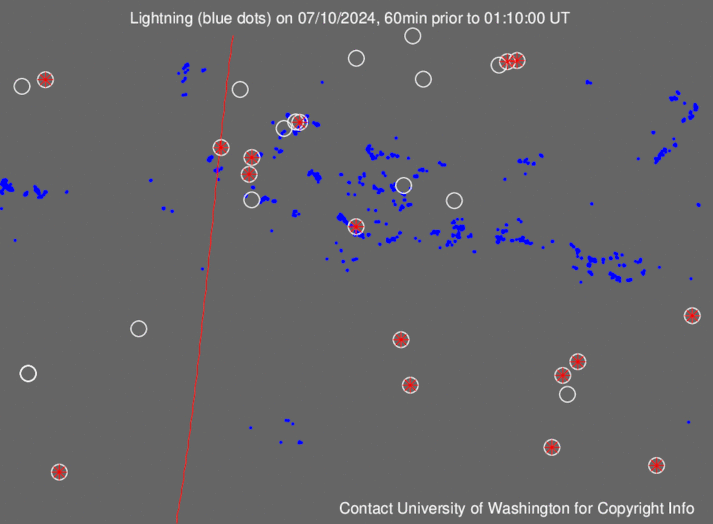
Can see the affect of the Northland land mass on last nights frontal storm activity in this loop
http://wwlln.net/WWLLN_movies/Movie_of_ ... an_BIG.gif
http://wwlln.net/WWLLN_movies/Movie_of_ ... an_BIG.gif
Re: Ye Olde Cold front - 10th & 11th June 2010
As I expected our rainfall was a bit lower than the 58mm we got from the last low pressure system, still 28mm to 9am so not too shabby at all. This means Nelson Aero will be almost at the average for June already if not past it and after getting almost double the average in May everything is looking quite saturated around here.
Its interesting looking at the photos I took when we first arrived in Nelson 6 weeks ago compared to now, the grass and parks were quite brown in comparison. Not as marked difference as we got in Perth were you go from sandpit to grassland in a couple of months but still quite noticeable.
Still its not making it any easier to explain to the better half this kind of weather isn't the norm for this area of New Zealand, she still thinks I told her porky's when I said Nelson's winter's were almost as sunny as Perth with less rain! At least I can listen to the rain falling on the roof of the dog house at night.
-
Storm Struck

- Posts: 4865
- Joined: Wed 17/11/2004 21:25
- Location: Belfast Christchurch
- Has thanked: 23 times
- Been thanked: 375 times
Re: Ye Olde Cold front - 10th & 11th June 2010
Got a wee sneaky SW wind here this morning not predicted, but you can get these sneaking in under the NW flow.
Even abit of weak CU running inland parralell to the Southern Alps.
I see MS have snow to 100m over Southland tomorrow night, now thats cold air and pretty much says snow to sea level by Sunday for coastal areas.
Again its a pitty theres bugger all moisture around, the models havnt budged on precipitation numbers so i think its going to be more a brief event than anything especially for inland areas.
Banks Peninnsula will no doubt benefit from the icy southerly but i would be surprised if even Mt Herbert got more than 5cm.
Canterbury, home of good rugby and severe storms
-
CHCH Weather Chaser

- Posts: 3460
- Joined: Thu 26/06/2008 16:10
- Location: Halswell / Hoon Hay Christchurch
- Has thanked: 0
- Been thanked: 0
Re: Ye Olde Cold front - 10th & 11th June 2010
The Southwest change was predicted, has been for a few days but with skies remaining clear from Yesterday which it is. Southerly at 30km.h here now. The winds will switch back to NE later today. Snow forecast to "near sea level" in Southland on Sunday. Yes, very little moisture, I see it should remain rather fine and chilly over the city through the weekend and Monday as well with just a chance of some wintry showers early Sunday morning perhaps. Looks to be a good system approaching next weekend (19th-20th), a long way off but big low area looks like it could feed heavy rain to the westcoast of the SI and then on the backend we may get a cold outbreak along the east, ofcourse nothing concrete and bound to change.Jasestorm wrote:Got a wee sneaky SW wind here this morning not predicted, but you can get these sneaking in under the NW flow.
Even abit of weak CU running inland parralell to the Southern Alps.
I see MS have snow to 100m over Southland tomorrow night, now thats cold air and pretty much says snow to sea level by Sunday for coastal areas.
Again its a pitty theres bugger all moisture around, the models havnt budged on precipitation numbers so i think its going to be more a brief event than anything especially for inland areas.
Banks Peninnsula will no doubt benefit from the icy southerly but i would be surprised if even Mt Herbert got more than 5cm.
Reporting Live from Southern Christchurch
Leighton Thomas
2014 Rainfall: Jan: 21mm Feb: 76mm March: 170mm April: 201mm YTD: 468mm
Leighton Thomas
2014 Rainfall: Jan: 21mm Feb: 76mm March: 170mm April: 201mm YTD: 468mm
-
spwill
- Posts: 9917
- Joined: Sun 29/06/2003 22:39
- Location: Mt Eden Auckland
- Has thanked: 847 times
- Been thanked: 869 times
Re: Ye Olde Cold front - 10th & 11th June 2010
Given the very cold upper level air with a long sea track there should be some decent Cbs along the SI eastern coastal fringe Sunday, assuming the flow will go proper southerly.very little moisture
-
Razor
- Moderator
- Posts: 5131
- Joined: Fri 10/02/2006 15:14
- Location: Halswell, Christchurch
- Has thanked: 718 times
- Been thanked: 930 times
Re: Ye Olde Cold front - 10th & 11th June 2010
Wouldn't be at all surprised to see a completely dry weekend here in ChCh. Blue Skies I see have scaled the risk back to 60% now. Flip a coin, SW or S?
Christchurch Rocks
-
David

- Posts: 7584
- Joined: Sat 18/08/2007 21:02
- Location: Howick, Auckland
- Has thanked: 416 times
- Been thanked: 830 times
- Contact:
Re: Ye Olde Cold front - 10th & 11th June 2010
The models showed a strong SW change to follow the front, yet we still have a gentle breeze, hmmm...
-
Razor
- Moderator
- Posts: 5131
- Joined: Fri 10/02/2006 15:14
- Location: Halswell, Christchurch
- Has thanked: 718 times
- Been thanked: 930 times
Re: Ye Olde Cold front - 10th & 11th June 2010
Michael will be guttedDavid wrote:The models showed a strong SW change to follow the front, yet we still have a gentle breeze, hmmm...
Christchurch Rocks
-
Michael
- Posts: 7210
- Joined: Thu 27/03/2003 12:04
- Location: Rainy Manurewa, Auckland - "City of Gales"
- Has thanked: 0
- Been thanked: 1 time
- Contact:
Re: Ye Olde Cold front - 10th & 11th June 2010
Undoubtedly it will come,howling its nuts off,can feel it its presence not far off.Its still a westerly here now.
David wrote:The models showed a strong SW change to follow the front, yet we still have a gentle breeze, hmmm...
-
RWood
- Posts: 3745
- Joined: Sat 24/01/2004 16:56
- Location: Wellington
- Has thanked: 188 times
- Been thanked: 123 times
Re: Ye Olde Cold front - 10th & 11th June 2010
As I commented earlier, a large area has had abnormally low sunshine in the last 3-4 weeks. Here in Wellington we will not be far above the alltime low for any 28-day period (this case ending this Saturday).Tim S wrote:Still its not making it any easier to explain to the better half this kind of weather isn't the norm for this area of New Zealand, she still thinks I told her porky's when I said Nelson's winter's were almost as sunny as Perth with less rain! At least I can listen to the rain falling on the roof of the dog house at night.
-
gllitz

- Posts: 1335
- Joined: Wed 04/01/2006 11:45
- Location: Perth, Western Australia
- Has thanked: 0
- Been thanked: 0
Re: Ye Olde Cold front - 10th & 11th June 2010
Most recent GFS run (00Z run) showing more promising numbers for at least a few flakes here around sea level in Canty (chch aero, anyway)...moderators, perhaps a different thread for the upcoming "antarctic blast of June 12/13th?"...It isn't really related to this thread and I have a sneaking suspicion the new thread may grow quickly! 
"Saru mo ki kara ochiru"
-
Michael
- Posts: 7210
- Joined: Thu 27/03/2003 12:04
- Location: Rainy Manurewa, Auckland - "City of Gales"
- Has thanked: 0
- Been thanked: 1 time
- Contact:
Re: Ye Olde Cold front - 10th & 11th June 2010
They go on about all these storms,yes we had some good winds from the E or N recently but this is up with these,typical now the trees have lost their leaves for he year,an easterly forecast now as foreign as space flight to arcturus.
-
Lawrence

- Posts: 958
- Joined: Mon 25/06/2007 09:11
- Location: Kirwee,Selwyn,Canterbury,157m ASL
- Has thanked: 169 times
- Been thanked: 68 times
Re: Ye Olde Cold front - 10th & 11th June 2010
You bet ya! the numbers on the latest runs are fantastic,right over Christchurch too.Could be a hell of dump if thing stay this way, right down to sea level.gllitz wrote:Most recent GFS run (00Z run) showing more promising numbers for at least a few flakes here around sea level in Canty (chch aero, anyway)...moderators, perhaps a different thread for the upcoming "antarctic blast of June 12/13th?"...It isn't really related to this thread and I have a sneaking suspicion the new thread may grow quickly!
-
snowstormwatcher

- Posts: 1643
- Joined: Wed 23/09/2009 09:45
- Location: South Canterbury. 20km inland from Timaru.
- Has thanked: 188 times
- Been thanked: 138 times
Re: Ye Olde Cold front - 10th & 11th June 2010
Im thinking it will be more of a southland otago event possibly coastal canterbury north of ashburton im not exepcting any snow here in south canterbury.
-
Richard

- Posts: 8372
- Joined: Tue 14/07/2009 07:32
- Location: Medbury, Inland North Canterbury
- Has thanked: 1657 times
- Been thanked: 800 times
Re: Ye Olde Cold front - 10th & 11th June 2010
gllitz wrote:Most recent GFS run (00Z run) showing more promising numbers for at least a few flakes here around sea level in Canty (chch aero, anyway)...moderators, perhaps a different thread for the upcoming "antarctic blast of June 12/13th?"...It isn't really related to this thread and I have a sneaking suspicion the new thread may grow quickly!
Given that i dont live anywhere near sea level or even anywhere near a coastline,i cant see myself getting too excited by what i see coming,certainly wont get any off those rogue storms that Jase got the other day.ya lucky bugger
-
Dale

- Posts: 1070
- Joined: Sun 27/07/2008 08:59
- Location: Greymouth - Feral Coast.. NZ
- Has thanked: 0
- Been thanked: 0
Re: Ye Olde Cold front - 10th & 11th June 2010
Well the showers and winds have certainly ramped up here over the last couple of hours.. cross fingers something doesnt take off tonight.
-
Storm Struck
- Posts: 4865
- Joined: Wed 17/11/2004 21:25
- Location: Belfast Christchurch
- Has thanked: 23 times
- Been thanked: 375 times
Re: Ye Olde Cold front - 10th & 11th June 2010
Yes latest model runs have a much better set up with more favourable moisture, i would actually not like to see it go any higher than that because generally when the precipitation numbers go up the freezing level follows.
But this is looking more of a Canterbury,Otago,Southland,Kaikoura event now as apposed to earlier on today where it was more a lower South Island event.
Yes Richard i even have a low risk of weak thunderstorms on Sunday on my website which you can view on my profile, maybe a clap of thunder or two with some heavier showers.
Often convective clouds as spwill mentioned earlier for near the east coast, can also bring some heavy falls of snow in those wintry CB's.
Canterbury, home of good rugby and severe storms
-
Lawrence
- Posts: 958
- Joined: Mon 25/06/2007 09:11
- Location: Kirwee,Selwyn,Canterbury,157m ASL
- Has thanked: 169 times
- Been thanked: 68 times
Re: Ye Olde Cold front - 10th & 11th June 2010
Looking at the moment to start about Midnight Saturday or early hours of SundayJasestorm wrote:But this is looking more of a Canterbury,Otago,Southland,Kaikoura event now as apposed to earlier on today where it was more a lower South Island event.
-
mattyj46
- Posts: 323
- Joined: Mon 21/07/2008 16:33
- Location: Brisbane, Australia, from Invercargill, New Zealan
- Has thanked: 2 times
- Been thanked: 28 times
Re: Ye Olde Cold front - 10th & 11th June 2010
Just a quick question for those who know alot more than me,
At the moment what are the chances of Fiordland (particulary the Te Anau) area of getting snow? The olds are heading off tomorrow afternoon and coming back Sunday night.
Cheers in advance.
At the moment what are the chances of Fiordland (particulary the Te Anau) area of getting snow? The olds are heading off tomorrow afternoon and coming back Sunday night.
Cheers in advance.
-
Lawrence
- Posts: 958
- Joined: Mon 25/06/2007 09:11
- Location: Kirwee,Selwyn,Canterbury,157m ASL
- Has thanked: 169 times
- Been thanked: 68 times
Re: Ye Olde Cold front - 10th & 11th June 2010
Saturday Afternoon.Mostly cloudy with a few sleety showers.mattyj46 wrote:Just a quick question for those who know alot more than me,
At the moment what are the chances of Fiordland (particulary the Te Anau) area of getting snow? The olds are heading off tomorrow afternoon and coming back Sunday night.
Cheers in advance.
Saturday Evening.Mostly cloudy with sleet. Showers possibly mixed with wet flurries.
Overnight.Snow showers or wet flurries
Sunday Morning.Persistant snow flurries or showers likely.
Sunday Afternoon.Cloudy with sunny periods with a chance of snow flurries or showers.
-
mattyj46
- Posts: 323
- Joined: Mon 21/07/2008 16:33
- Location: Brisbane, Australia, from Invercargill, New Zealan
- Has thanked: 2 times
- Been thanked: 28 times
Re: Ye Olde Cold front - 10th & 11th June 2010
Sweet as cheers mateKarshvardidgâh wrote:Saturday Afternoon.Mostly cloudy with a few sleety showers.mattyj46 wrote:Just a quick question for those who know alot more than me,
At the moment what are the chances of Fiordland (particulary the Te Anau) area of getting snow? The olds are heading off tomorrow afternoon and coming back Sunday night.
Cheers in advance.
Saturday Evening.Mostly cloudy with sleet. Showers possibly mixed with wet flurries.
Overnight.Snow showers or wet flurries
Sunday Morning.Persistant snow flurries or showers likely.
Sunday Afternoon.Cloudy with sunny periods with a chance of snow flurries or showers.
-
NZ Thunderstorm Soc
- Posts: 18489
- Joined: Wed 12/03/2003 22:08
- Location: Raukapuka Geraldine
- Has thanked: 1769 times
- Been thanked: 1412 times
Re: Ye Olde Cold front - 10th & 11th June 2010
gllitz wrote:Most recent GFS run (00Z run) showing more promising numbers for at least a few flakes here around sea level in Canty (chch aero, anyway)...moderators, perhaps a different thread for the upcoming "antarctic blast of June 12/13th?"...It isn't really related to this thread and I have a sneaking suspicion the new thread may grow quickly!
Iv'e created a new topic for you, Glen.
JohnGaul
NZThS
JohnGaul
NZThS
NZThS
-
Talbotm
- Posts: 262
- Joined: Fri 09/10/2009 10:26
- Location: Waddington, Canterbury 300msl
- Has thanked: 0
- Been thanked: 0
Re: Ye Olde Cold front - 10th & 11th June 2010
Should be a good storm if models are to go by hopefully we get abit more snow here than last weekend. Just hope moisture gets up here. I see weather watch mentioned snow around mt Taranaki to a few hundred metres. 