Page 5 of 7
Re: Thunderstorm Risk - 11th,12th October - North and South
Posted: Sat 12/10/2013 17:02
by dogmelon
Well look at that, the second line is doing the same turn to the North of chc like the first one. How lame.
Re: Thunderstorm Risk - 11th,12th October - North and South
Posted: Sat 12/10/2013 17:06
by Richard
I thought when a NW wind came up about 11.00 that would be it for here but the last half hour i think it will hit here now,very dark to the south with distant rumbles
Re: Thunderstorm Risk - 11th,12th October - North and South
Posted: Sat 12/10/2013 17:15
by KiwiWeather
Terrific photo's you guys!!
Re: Thunderstorm Risk - 11th,12th October - North and South
Posted: Sat 12/10/2013 17:27
by Richard
Here's how it looking now,the centre of the storm is coming this way too
Couldnt load the photo on the forum,had to load it on photobucket

Re: Thunderstorm Risk - 11th,12th October - North and South
Posted: Sat 12/10/2013 17:29
by Razor
Continuos thunder in chch just now. Hail to boot
Re: Thunderstorm Risk - 11th,12th October - North and South
Posted: Sat 12/10/2013 17:34
by NZ Thunderstorm Soc
Yes.

A lovely thunderstorm day, here.

2 of them. You don't get that very often
I'm one very happy person
Re: Thunderstorm Risk - 11th,12th October - North and South
Posted: Sat 12/10/2013 17:35
by dogmelon
I saw ~6 bits of IC lightning with occasional Thunder here in Hornby. It also had a bit of heavy rain. Does anyone know why the best bits of storms like to skirt the city?
Re: Thunderstorm Risk - 11th,12th October - North and South
Posted: Sat 12/10/2013 17:35
by Chris Raine
We have had thunderstorms in Oamaru since 1pm .The one at 3.30pm had good CG strikes and big hail .,Our fire sirens at Shag Point were hit by lightning , blew the electronics when we went down to have a look . Oh damn ! Still lots of Cb's floating around Oamaru as I type this
Re: Thunderstorm Risk - 11th,12th October - North and South
Posted: Sat 12/10/2013 17:36
by NZ Thunderstorm Soc
dogmelon wrote: Does anyone know why the best bits of storms like to skirt the city?
No.
Re: Thunderstorm Risk - 11th,12th October - North and South
Posted: Sat 12/10/2013 17:40
by Skywatcher
The best lightning also had the worst conditions with the arrival of the gust front (recorded 62km/h) and torrential rain/hail briefly reaching 100mm/h ! Rain and hail slush was pouring over the gutters.
Re: Thunderstorm Risk - 11th,12th October - North and South
Posted: Sat 12/10/2013 17:42
by Powermad
20131012_171434.jpg
Wallcloud lo res panorama
Dunno why it's sideways!
Re: Thunderstorm Risk - 11th,12th October - North and South
Posted: Sat 12/10/2013 17:50
by FIREFROG

we have only had 1.2mm rain - heaps of flashes and thunder - spoke too soon, its now gusting 34kph SW and hailing

Re: Thunderstorm Risk - 11th,12th October - North and South
Posted: Sat 12/10/2013 18:00
by Richard
Hail storm just gone through,peas size thankfully
Re: Thunderstorm Risk - 11th,12th October - North and South
Posted: Sat 12/10/2013 18:10
by Lacertae
Just back home, not a lot of photos (and no lightning ...) but this gust front looked so cool I don't care.

Re: Thunderstorm Risk - 11th,12th October - North and South
Posted: Sat 12/10/2013 18:15
by Orion
It was a very defined wall-cloud, wasn't it.
I'm still hoping to hear where the 2 to 2.5cm hail was photographed and observed?
Report of 1.5cm hail at Westerfield.
Re: Thunderstorm Risk - 11th,12th October - North and South
Posted: Sat 12/10/2013 18:18
by Weather Watcher
Beautiful photos Lacertae.
Re: Thunderstorm Risk - 11th,12th October - North and South
Posted: Sat 12/10/2013 18:20
by matttbs
Was coming down mt hutt access road when the storm hit. Huge hail and plenty of lightning. Got a couple small dents in my car too.. Grrrrrr!
Re: Thunderstorm Risk - 11th,12th October - North and South
Posted: Sat 12/10/2013 18:26
by NZstorm
Well done Jason. Went for high risk and mentioned the jet stream and onshore winds. Good convective forecasting!
Nice gust front pics.
Re: Thunderstorm Risk - 11th,12th October - North and South
Posted: Sat 12/10/2013 18:29
by 03Stormchaser
Not my photo but from near Mt Somers
Re: Thunderstorm Risk - 11th,12th October - North and South
Posted: Sat 12/10/2013 18:37
by Powermad
Wonder what the combined cells will be like when they hit Wellington?
Re: Thunderstorm Risk - 11th,12th October - North and South
Posted: Sat 12/10/2013 18:49
by Orion
NZstorm wrote:Well done Jason. Went for high risk and mentioned the jet stream and onshore winds. Good convective forecasting!
Nice gust front pics.
Yes, well done.
The hail here was probably marginal for denting cars, nevertheless it was the biggest I've ever seen and I was glad the car was under cover.

Re: Thunderstorm Risk - 11th,12th October - North and South
Posted: Sat 12/10/2013 18:50
by Lacertae
A stitched panoramic view I shot just after crossing the Rakaia back towards Christchurch. I wanted to get around the edge of the front to the left by driving towards Southbridge, avoid the rain and hopefully shot some lightning from behind the front but the whole damn thing was wider than I thought ...
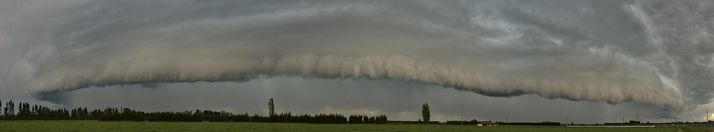 Gust Front
 by
Seabird NZ, on Flickr
Re: Thunderstorm Risk - 11th,12th October - North and South
Posted: Sat 12/10/2013 19:13
by Cook
Great photos, thanks.
Re: Thunderstorm Risk - 11th,12th October - North and South
Posted: Sat 12/10/2013 19:19
by mikestormchaser
007 (400x267).jpg
012 (450x300).jpg
What an awesome thunderstorm day!! it can keep these days up on a saturday to, just perfect
Chased with jason and meet up with steve and aaron through out the day. got some big hail in mayfield i beleieve we were? and they would have been 2 to 2.5cm
Some close lightning but none really observed overly well! i did however get 3 lots on film while jason was driving.
Anyways here is my best pic of the gust front , as the 2nd storm moved in!
Also those are some awesome pictures guys to! great to see them from different angles. particuly the one with aaron in it lacatae

Re: Thunderstorm Risk - 11th,12th October - North and South
Posted: Sat 12/10/2013 19:20
by NZ Thunderstorm Soc
Yes, the old gusto front does look dramatic, and the associated wind change and the heavy rain accompanying it, with the added lightning features like today.
Even I closely watched , there was no tornado effect, as the cloud rolled over, despite the active lightning within the cloud, in behind.
