Page 1 of 1
Is this a horse shoe funnel?
Posted: Thu 11/11/2004 16:26
by Thunder
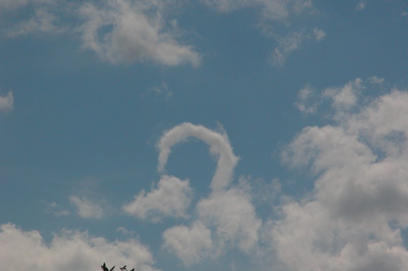
I believe what I've seen today might be a horse shoe funnel. Nothing spectacular at all but interesting none the less. What do you guys think? It hanged around for about a minute and a half, so just had enough time to get the camera and take some pics before it dissapated.


Here's a link to a page that has some horse shoe funnel pics plus info:
http://www.k5kj.net/hshoe.htm
The sun has come out today so that's made the day a bit more joyous if anything.
Posted: Thu 11/11/2004 16:33
by spwill
Looks like nothing to me Aaron.

Have just bought a Cannon Eos 300 digital.

Aaron, your funnel cloud photo from several weeks back has set the bench mark (high) for the photo comp.
Posted: Thu 11/11/2004 16:42
by Thunder
Looks like nothing becasue it isn't interesting? or
Looks like nothing becasue it isn't a horse shoe funnel?
I thought the photo comp was for the best Cumulonimbus photo. If my funnel photo from the 16th Oct is allowed in, horaay! But I don't think it's allowed...

Great camera!!!!!:o You'll get marvalous images from that one.
Me, I'll stick with my Nikon

Next up is a decent video camera!
Posted: Thu 11/11/2004 17:32
by spwill
I think it's just the ragged edge of a bit of cumulus even if it did last 1 min +.
Photo comp should include any photo on weather even if its a photo of Drizzel
Posted: Thu 11/11/2004 18:09
by GraemeWi
Could you put up a full sized crop of the object in the picture? - I recon it looks like one of those horse shoe things, but a closer view will help.
Cheers,
G
Posted: Thu 11/11/2004 19:50
by Thunder
You'll note I changed the title plus a few words to make it more of an "I don't know?"
What's your opinion on the photo thing Steven W? It would be cool if my FC shot could go in but if not that's cool. I actually thought it was for the best shot of a Cb.....
Graeme, you can click on the images for a larger view, is that big enough? I'll put up a full sized crop tomorrow anyway. I put the pics on my computer at work but deleted them off my camera. Will do tomorrow!!
When I first saw it, it was away from the Cu completely so it might be something

Posted: Thu 11/11/2004 20:32
by Thunder
Here's another pic of a horse shoe vortex from Australian storm chaser Dave Ellem:
http://www.australiasevereweather.com/p ... 25de01.jpg
And story for that chase:
http://www.nswstorms.com/storm_chasing/ ... -10-06.htm
Posted: Fri 12/11/2004 10:26
by Manukau heads obs
i think it will be just swirling updrafts...swirling in a large arc .....
interesting, but a funnel, and no rotation, just a updraft curving in a curve....
thats my spin on it, LOL!
or was the cloud actualy spinning?
i did see myself a long tape like cloud , that was horizontaly aligned...it was in the lee of the coastal cliffs in a NW wind, as so i assumed they setup the rotation...
any hills/object around aron?
Posted: Sat 13/11/2004 07:12
by NZstorm
I don't think this is anything of meteorological significance.
As others have suggested, some convective turbulence condencing.
It is interesting to get such photos for discussion Aaron.
Posted: Sat 13/11/2004 08:54
by GraemeWi
I've had a look through a couple of sites on the net, and the images of Horseshoe-vortices look the same as Aaron's.
They don't seem to be specifically associated with a particular type of convection, just a vortex at the right time in the right place.
Cheers,
G
Posted: Sat 13/11/2004 11:05
by Thunder
As I understand they can often be associated with just small cumulus etc and not thunderstorms. It could be it might not be? Interesting none the less, cheers guys.
And I forgot it was a public holiday yesterday so I won't be getting that zoomed in shot till Monday, doh!
Posted: Mon 15/11/2004 10:50
by Thunder
Here's that zoomed in view
Were there any hills around? No, I took this pic in town. There is the Port Hills but they're about 8 or 9km away. And could I see it spinning, no I couldn't. But, even when Steve and me saw that funnel out north of Chch we couldn't even see that spinning, we could definately see the cloud base rotating but the funnel itself was impossible to see spinning. I think I might have at one point seen that FC north of Chch rotating but it's a vague memory. You could more or less see it growing in length and condensing up and down.
Posted: Mon 15/11/2004 11:17
by TonyT
Aaron, there were some interesting things happening in the sky that day - if you can get access to your very hi-res satpix for that afternoon it might be worth a look. It was a very humid day with a moderate NE breeze and lots of low level moisture, but the moist layer was very shallow and only along the coast. There was only light NE airflow onto Canterbury, so the surface NE'er wasnt a lee trough wind but a genuine NE breeze or sea breeze, as it seemed to be more SE at Amberley.
Driving home from Chch to Amberley mid afternoon I noticed a very long, smooth cloud centred over or just seaward of the coast, and running fully from the Waimak river mouth area to the hills north of the Waipara river - that must be 40km or more. The cloud was very narrow, I would estimate 500m, no more, and had the classic look of a lenticular. Now, as you know, lenticulars are very rare below about 3000ft, but this one must have had a base of 300-500ft and tops perhaps 1000ft above that - very shallow. I'm guessing the low level windflow was very stable, and there was gentle uplift as the sea breeze came off the sea and onto the land (uplift on coasts is well documented). Because the air was so humid it formed a cloud, and because the wind was so light and the flow so stable, the cloud didnt break up or get rough around the edges, it stayed perfectly smooth. Turbulence must have been virtually zero, with little if any vertical mixing. I could also see what looked like some wave clouds inland from this coastal cloud, but they were more broken - probably the result of some convection over the land surface.
Anyway, the point is, that the conditions which would need to have existed to support this type of cloud, would also be conducive to allowing the development of a horseshoe vortex such as the one you believe you saw - such a small and delicate vortex could only survive (or indeed be created in the first place) in a stable atmosphere with little or no turbulence to destroy it. Obvioulsy the winds were light enough to allow this, but just strong enough to produce whatever gusts or drafts needed to generate it in the first place.
Posted: Mon 15/11/2004 13:03
by Thunder
Thanks for the detailed info Tony.
Here's a high res (sort of) sat pic for that day at 2.55pm. The problem is it was all skewed looking, I've repaired so it looks a bit better.
Posted: Tue 16/11/2004 08:17
by 03Stormchaser
I have had a look around the web and would agree that it is a horse shoe funnel Aaron!
That zoomed in view shows it clearly!!
If only other forum users werent so jealous!! lol


