Max temperature forecast for Dallas on Monday is -9C, min Monday night -15C . Houston max on Monday is -4C, Monday night-12C
Texas cold
-
spwill
- Posts: 10197
- Joined: Sun 29/06/2003 22:39
- Location: Mt Eden Auckland
Texas cold
Very cold weather and snow will affect much of Texas over coming days.
Max temperature forecast for Dallas on Monday is -9C, min Monday night -15C . Houston max on Monday is -4C, Monday night-12C .
.
Max temperature forecast for Dallas on Monday is -9C, min Monday night -15C . Houston max on Monday is -4C, Monday night-12C
-
NZ Thunderstorm Soc
- Posts: 19101
- Joined: Wed 12/03/2003 22:08
- Location: Raukapuka Geraldine
Re: Texas cold
Yes I have noticed that with Dallas only getting up the 1C the other day, whereas their temperatures are usually quite mild for the time of year.spwill wrote: Sat 13/02/2021 22:32 Very cold weather and snow will affect much of Texas over coming days.
Max temperature forecast for Dallas on Monday is -9C, min Monday night -15C . Houston max on Monday is -4C, Monday night-12C
JohnGaul
NZThS
NZThS
-
tgsnoopy

- Posts: 3671
- Joined: Fri 25/03/2005 21:17
- Location: Tauranga, NZ (Curse you COVID-19 :-( )
Re: Texas cold
There have been some terrible crashes. One was on elevated roadway (which always freezes first) in Dallas area. Traffic was coming up the ramp with power on up the incline and then when it leveled out were on slick ice from freezing rain unable to stop. It continued until the piled up cars were visible from the incline & people could stop in time. Sadly a number of fatalities. If you look for them you will find multiple videos, they are terrible.
-
Nev

- Moderator
- Posts: 6422
- Joined: Tue 07/03/2006 15:24
- Location: Waiheke Island, Hauraki Gulf
Re: Texas cold
TVNZ ran a story about a spectacular pile-up in Fort Worth last night…
https://www.tvnz.co.nz/one-news/world/s ... s-motorway
https://www.tvnz.co.nz/one-news/world/s ... s-motorway
The ice storm came as a polar vortex — swirling air that normally sits over the Earth's poles — has moved near the US-Canada border, resulting in colder weather farther south than usual, said Steve Goss, a meteorologist with the National Weather Service’s Storm Prediction Center in Norman, Oklahoma.
“As a result we’re getting unusually or unseasonably cold air that’s spilling south across a good portion of the United States east of the Rocky Mountains,” he said. ...
-
Awhituobs
- Posts: 2256
- Joined: Tue 10/09/2019 07:20
- Location: Waiuku
Re: Texas cold
a lot of people will be driving using cruise control ? (re speed)
Last edited by Awhituobs on Sun 14/02/2021 20:44, edited 1 time in total.
Brian Hamilton
www.weather-display.com/windy/gb/grahamsbeach.htm
www.weather-display.com/windy/gb/grahamsbeach.htm
-
NZstorm

- Posts: 11333
- Joined: Mon 10/03/2003 19:38
- Location: Grey Lynn, Auckland
Re: Texas cold
Houston gets hurricane warnings, now under a dangerous winter storm warning.
Disaster declaration for Texas due to stress on the electric grid.
Disaster declaration for Texas due to stress on the electric grid.
-
Cyclone Tracy
- Posts: 2488
- Joined: Thu 07/09/2017 19:25
- Location: North Shore, Auckland
Re: Texas cold
Here is the culprit from early to mid January. viewtopic.php?p=197665#p197665
These projected cold anomalies are staggering. I can't ever remember seeing a map like this over such a wide area in the U.S and into the gulf.
These projected cold anomalies are staggering. I can't ever remember seeing a map like this over such a wide area in the U.S and into the gulf.
You do not have the required permissions to view the files attached to this post.
-
spwill
- Posts: 10197
- Joined: Sun 29/06/2003 22:39
- Location: Mt Eden Auckland
Re: Texas cold
Dallas which is a similar latitude to Newcastle Australia is currently -8C with snow, the forecast low tonight is -13C.
Colder tomorrow.
Colder tomorrow.
-
NZstorm
- Posts: 11333
- Joined: Mon 10/03/2003 19:38
- Location: Grey Lynn, Auckland
Re: Texas cold
Goodland Kansas currently on -29C, Dodge City -23C, Wichita -22C. Tornado season only 2 months away.
-
tgsnoopy
- Posts: 3671
- Joined: Fri 25/03/2005 21:17
- Location: Tauranga, NZ (Curse you COVID-19 :-( )
Re: Texas cold
Insane temperature variation.
You do not have the required permissions to view the files attached to this post.
-
Cyclone Tracy
- Posts: 2488
- Joined: Thu 07/09/2017 19:25
- Location: North Shore, Auckland
Re: Texas cold
The cost of this winter storm is going to be enormous. It's looks like Texas's renewable energy has failed under the conditions, mass blackouts associated with frozen wind turbines at peak demand.
-
Nev
- Moderator
- Posts: 6422
- Joined: Tue 07/03/2006 15:24
- Location: Waiheke Island, Hauraki Gulf
Re: Texas cold
That map doesn't show actual real temps though, but rather 'feels-like' temps.
(see their real Air Temps versus the Wind Chill & Heat Index)
However, the lowest real US air temp recorded yesterday was -45°F (-43°C) at Kabetogama Lake in Minnesota, compared to 90°F (32°C) at Palm Beach Gardens, Titusville and Brighton all in Florida. So there was indeed a real air temp variation of 135°F (75°C).
-
tgsnoopy
- Posts: 3671
- Joined: Fri 25/03/2005 21:17
- Location: Tauranga, NZ (Curse you COVID-19 :-( )
Re: Texas cold
Yes, I expect they created that on wind chill because if you were outside, that's what you feel. It says so clearly on the image. I find it hard to comprehend such a vast difference. Interesting they also got a real temperature difference of 135 F (Sorry, I generally won't use ° if it's in F)Nev wrote: Tue 16/02/2021 06:57That map doesn't show actual real temps though, but rather 'feels-like' temps.
(see their real Air Temps versus the Wind Chill & Heat Index)
However the lowest real US air temp recorded yesterday was -45°F (-43°C) at Kabetogama Lake in Minnesota, compared to 90°F (32°C) at Palm Beach Gardens, Titusville and Brighton all in Florida. So there was indeed a real air temp variation of 135°F (75°C).
-
NZstorm
- Posts: 11333
- Joined: Mon 10/03/2003 19:38
- Location: Grey Lynn, Auckland
Re: Texas cold
Gulf Coast town of Galveston Texas down to -6C with strong winds.
Oklahoma City -21C.
Oklahoma City -21C.
-
Awhituobs
- Posts: 2256
- Joined: Tue 10/09/2019 07:20
- Location: Waiuku
Re: Texas cold
crazy
must be some unusually positioned jet streams
(hence why Florida is warmer than normal on the other side of that stuck weather system)
must be some unusually positioned jet streams
(hence why Florida is warmer than normal on the other side of that stuck weather system)
Brian Hamilton
www.weather-display.com/windy/gb/grahamsbeach.htm
www.weather-display.com/windy/gb/grahamsbeach.htm
-
NZstorm
- Posts: 11333
- Joined: Mon 10/03/2003 19:38
- Location: Grey Lynn, Auckland
Re: Texas cold
February and March is the Severe thunderstorm season for Florida, and Georgia too.Awhituobs wrote: Tue 16/02/2021 11:52 crazy
must be some unusually positioned jet streams
(hence why Florida is warmer than normal on the other side of that stuck weather system)
Tornado warning for SE Georgia last hr.
AT 442 PM EST, A CONFIRMED LARGE AND EXTREMELY DANGEROUS TORNADO
WAS LOCATED 7 MILES SOUTHEAST OF ARLINGTON, OR 12 MILES NORTH OF
COLQUITT, MOVING NORTHEAST AT 60 MPH.
-
NZstorm
- Posts: 11333
- Joined: Mon 10/03/2003 19:38
- Location: Grey Lynn, Auckland
Re: Texas cold
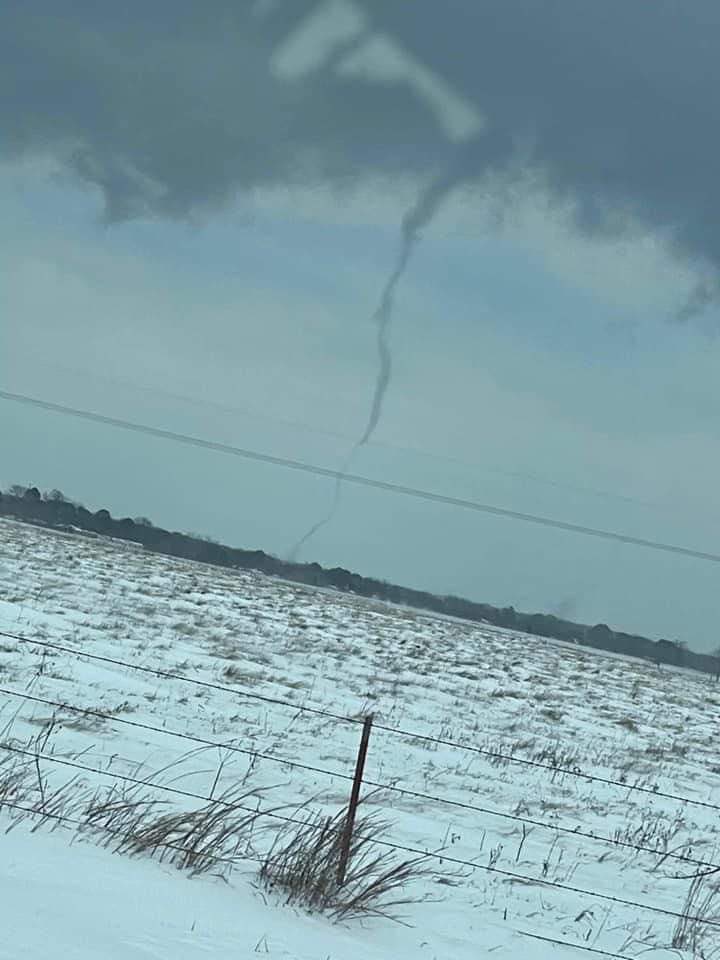
A tornado reported from east Texas today in the subzero snowy conditions. Probably a waterspout.
-
NZ Thunderstorm Soc
- Posts: 19101
- Joined: Wed 12/03/2003 22:08
- Location: Raukapuka Geraldine
Re: Texas cold
Yes. According to the Blitz, there is a line of thunderstorms moving east to the east of the cold air.Awhituobs wrote: Tue 16/02/2021 11:52 crazy
must be some unusually positioned jet streams
(hence why Florida is warmer than normal on the other side of that stuck weather system)
JohnGaul
NZThS
NZThS
-
NZstorm
- Posts: 11333
- Joined: Mon 10/03/2003 19:38
- Location: Grey Lynn, Auckland
Re: Texas cold
Seasonal temperature outlook for the US. Feb/Mar/Apr
https://www.cpc.ncep.noaa.gov/products/ ... 1_temp.gif
https://www.cpc.ncep.noaa.gov/products/ ... 1_temp.gif
-
Awhituobs
- Posts: 2256
- Joined: Tue 10/09/2019 07:20
- Location: Waiuku
Re: Texas cold
so that was produced 21 Jan that projection
so that means there is going to be needed the next 2 months to be substantially above normal temperature
which would need a complete flip of the current weather pattern...whats the chances?
so that means there is going to be needed the next 2 months to be substantially above normal temperature
which would need a complete flip of the current weather pattern...whats the chances?
Brian Hamilton
www.weather-display.com/windy/gb/grahamsbeach.htm
www.weather-display.com/windy/gb/grahamsbeach.htm
-
NZstorm
- Posts: 11333
- Joined: Mon 10/03/2003 19:38
- Location: Grey Lynn, Auckland
-
Awhituobs
- Posts: 2256
- Joined: Tue 10/09/2019 07:20
- Location: Waiuku
Re: Texas cold
it would have been relatively high dew point compared to places at a higher latitude and hence more ice on the turbine blades?
Brian Hamilton
www.weather-display.com/windy/gb/grahamsbeach.htm
www.weather-display.com/windy/gb/grahamsbeach.htm
-
NZstorm
- Posts: 11333
- Joined: Mon 10/03/2003 19:38
- Location: Grey Lynn, Auckland
Re: Texas cold
Yes, probably more icing than usual with this storm.Awhituobs wrote: Thu 18/02/2021 16:17 it would have been relatively high dew point compared to places at a higher latitude and hence more ice on the turbine blades?
Texas is no stranger to cold weather in winter, the high plains get freezing storms every winter. It's probably not unusual for the wind turbines to start breaking down in severe weather. Gas supply was disrupted as well.
-
Awhituobs
- Posts: 2256
- Joined: Tue 10/09/2019 07:20
- Location: Waiuku
Re: Texas cold
I also have read where Texas is independant power , i.e they could not easily get more power from other states
Brian Hamilton
www.weather-display.com/windy/gb/grahamsbeach.htm
www.weather-display.com/windy/gb/grahamsbeach.htm
-
NZstorm
- Posts: 11333
- Joined: Mon 10/03/2003 19:38
- Location: Grey Lynn, Auckland
Re: Texas cold
The cold snap is expected to be the biggest insurance event in Texas history. Also 30 deaths in Texas blamed on the freeze.