yes thats right foggy, i helped with the GeoTech stuff on that casino. There was also one there for the new BNZ building too.
are you also aware of the new Ibis hotel (7 storey) on the corner of where macca's is (claudelands bridge) .Should be starting that soon as they intend to have it built by field days 2006. And then there is the new hospital too. Go hamiltron!!
Just went up to the domain and that Cb is huge!!!!! but is beginning to look a bit spent, but as far as size goes...sheesh.
a break in the Westerlies
Forum rules
These topics are a read-only archive and may be subject to out-of-date information.
For today's weather discussion head to: New Zealand Weather & Climate
These topics are a read-only archive and may be subject to out-of-date information.
For today's weather discussion head to: New Zealand Weather & Climate
-
Manukau heads obs
- Posts: 12305
- Joined: Mon 10/03/2003 16:30
- Location: West Coast Road, Manukau Peninsula, North Island
can see the lightning bolts over pukekohe way now from here!
this is huge now, covers half the sky!
its going off!
real time data from where the CB is:
http://www.tokaanuskihire.co.nz/pukekohe/flash/
8mm there already in a short time!
this is huge now, covers half the sky!
its going off!
real time data from where the CB is:
http://www.tokaanuskihire.co.nz/pukekohe/flash/
8mm there already in a short time!

-
Willoughby

- Site Admin
- Posts: 4441
- Joined: Sat 14/06/2003 16:18
- Location: Darwin, Australia: Storm city
Yes, but it is very ugly (ibis)C-Nimbus wrote: are you also aware of the new Ibis hotel (7 storey) on the corner of where macca's is (claudelands bridge) .Should be starting that soon as they intend to have it built by field days 2006. And then there is the new hospital too. Go hamiltron!!
Heavy downpours currently in Cambridge and they are developing nicely across the basin, especially NW across to Pukekohe as Brian has said!
Even up to Kaitaia is getting them!
18c, dp 12c.. getting uncomfy with the lack of wind.
-
Storm Struck

- Posts: 5056
- Joined: Wed 17/11/2004 21:25
- Location: Belfast Christchurch
Looks to be another spring classic storm up there guys nice one  some small CU to SE of BP this morning didnt go farr has now fizzled out.
Another jolt this morning just felt this one i was in shower and felt ground move slightly and pressure of water glitched abit.
It was centred just Near Hamner Springs of 5.1 on the Richter Scale I would imagine Culverdon would have felt this very well.
Cheers.
JASON.
Another jolt this morning
It was centred just Near Hamner Springs of 5.1 on the Richter Scale I would imagine Culverdon would have felt this very well.
Cheers.
JASON.
-
C-Nimbus
- Posts: 692
- Joined: Tue 20/01/2004 13:22
- Location: Waitakere City - Westie!!
-
spwill
- Posts: 10196
- Joined: Sun 29/06/2003 22:39
- Location: Mt Eden Auckland
-
Willoughby
- Site Admin
- Posts: 4441
- Joined: Sat 14/06/2003 16:18
- Location: Darwin, Australia: Storm city
Awesome!!! Not often do we see Cb's in that view!spwill wrote:Flew from the SouthIsland to Auckland this afternoon.
From the Aircraft I could see nice cloud biuld ups form Taranaki north, there looked to be Thunderstorms in the Waikato/ South Ak area.
This Cb was over Waikato.
Thunderstorm which rolled in from the Cambridge area I think, delivered some loud claps over here at around 2.40.. clearing now with recent heavy shower. Wahoooo!
I think there was some 'roll'? cloud seen from here to the west
RR gif soon

-
squid
- Posts: 1304
- Joined: Thu 16/06/2005 13:57
- Location: Caboolture,QLD
this afternoon has been full of action and it far from over yet had a nice storm go through at 2 30pm with thunder and heavy rain the anvils are very crisp and yes i noticed the severe thunderstorm warning for western northland and auckland issued at 3 30 pm it is heating up again now back up to 19 and very stucky and building up again with some big towers going up looking black/blue in the distance and hey i am in the kaipara woot go me i reckon 2morow could be similar aswell and maby sunday well thats my forcast see how well i go go the storms an intersting afternoon and evening ahead
Last edited by squid on Sun 16/10/2005 09:01, edited 1 time in total.
-
spwill
- Posts: 10196
- Joined: Sun 29/06/2003 22:39
- Location: Mt Eden Auckland
-
spwill
- Posts: 10196
- Joined: Sun 29/06/2003 22:39
- Location: Mt Eden Auckland
-
Manukau heads obs
- Posts: 12305
- Joined: Mon 10/03/2003 16:30
- Location: West Coast Road, Manukau Peninsula, North Island
-
Willoughby
- Site Admin
- Posts: 4441
- Joined: Sat 14/06/2003 16:18
- Location: Darwin, Australia: Storm city
Cb's lowering to 600m here according to the latest METARs, and 750m at Auckland Airport. 15c here, dewpoint 14c, still showering with mostly calm winds.
You can see all that convection in the RR animation here fuelled by wet warm Waikato Basin grounds 
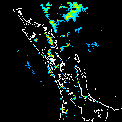
GIF runs from 12.30 to 4.15pm, with 3 frames missing
You can see all that convection in the RR animation here fuelled by wet warm Waikato Basin grounds
GIF runs from 12.30 to 4.15pm, with 3 frames missing
-
spwill
- Posts: 10196
- Joined: Sun 29/06/2003 22:39
- Location: Mt Eden Auckland
-
TonyT

- Moderator
- Posts: 3006
- Joined: Thu 08/05/2003 11:09
- Location: Amberley, North Canterbury
-
Thunder
- Posts: 2068
- Joined: Wed 12/03/2003 19:47
- Location: Mt Somers
Awsome stuff Spwill!! Certainly looks like something, and the way it has it's own little wall cloud like feature makes it cool! I'd say it's a funnel.
Metservice now have some interesting comments regarding Sunday for down here that could prove fruitfull:
First the Severe Weather Outlook:
Unfortunately I think one of the 3 frames Foggy is missing is the 2:30pm one! lol. This is the 3pm one (going by how many frames there are and Foggies times from above). I've enlarged it but you can't actually zoom in on those radar's.
Cheers
Metservice now have some interesting comments regarding Sunday for down here that could prove fruitfull:
First the Severe Weather Outlook:
And then the general brief forecast for the South Island:Valid: Sun 16 Oct to Wed 19 Oct
Issued: Fri 14 October 2005 at 02:24 pm
On Sunday, daytime heating may contribute to localised heavy showers over parts of the South Island with a similar set-up for parts of the North Island on Monday.
Hopefully something happens on Sunday.South Island, fine or becoming fine, but afternoon or evening showers possible about the ranges.
Unfortunately I think one of the 3 frames Foggy is missing is the 2:30pm one! lol. This is the 3pm one (going by how many frames there are and Foggies times from above). I've enlarged it but you can't actually zoom in on those radar's.
Cheers
You do not have the required permissions to view the files attached to this post.

Aaron Wilkinson
-
Michael

- Posts: 7210
- Joined: Thu 27/03/2003 12:04
- Location: Rainy Manurewa, Auckland - "City of Gales"
-
Manukau heads obs
- Posts: 12305
- Joined: Mon 10/03/2003 16:30
- Location: West Coast Road, Manukau Peninsula, North Island
-
NZstorm

- Posts: 11333
- Joined: Mon 10/03/2003 19:38
- Location: Grey Lynn, Auckland
-
NZstorm
- Posts: 11333
- Joined: Mon 10/03/2003 19:38
- Location: Grey Lynn, Auckland
There was a very good buildup on top of it, so you would expect a tornado/waterspout to have formed. Pity spwill couldn't continue to observe it.i wonder how much more it developed!
Notice that buildup over northern Waikato at the moment Brian. A bit of late day heating is producing a shower/possible storm.
-
Manukau heads obs
- Posts: 12305
- Joined: Mon 10/03/2003 16:30
- Location: West Coast Road, Manukau Peninsula, North Island
sure was,it was that same system that i photographed earlier of waiuku, but the most intense area kept on migrating NE, along the line of the whole shower line,i think becuase of the sea breeze that had developed in behind it...There was a very good buildup on top of it
it was ink black looking from here about that time the photo was taken by spwill
we sure seem to be getting alot of funnel clouds lately, or is just that we are looking for them?
notice the rotation in the rain radar seq foggy did?...i.e a upper level low over the north waikato, which produced the cooling above
-
spwill
- Posts: 10196
- Joined: Sun 29/06/2003 22:39
- Location: Mt Eden Auckland
-
squid
- Posts: 1304
- Joined: Thu 16/06/2005 13:57
- Location: Caboolture,QLD
-
Willoughby
- Site Admin
- Posts: 4441
- Joined: Sat 14/06/2003 16:18
- Location: Darwin, Australia: Storm city
BoM/WZ didn't see this coming..Foggy Hamilton wrote:Severe late thunderstorms instore for Darwin too tomorrow.
Wettest: 28.6mm Darwin Ap, NT
19mm yesterday at Hamilton Ap compared with 9 downtown.
Anyway, looking forward to 4 incoming days of afternoon convective heat showers here!
And I think the MetService and all the models are going to be underestimating these super-high evapotranspiration rates we're sitting on, so thunderstorms may just be possible again!
Too bad there will be a lack of upper-cold air.
I'll expect to see lots of T/Cu today in our skies today