HIGH SEAS WEATHER WARNING FOR METAREA 10 ISSUED BY THE AUSTRALIAN BUREAU OF
METEOROLOGY, BRISBANE 1929 UTC 16 April 2006
GALE WARNING FOR NORTH EASTERN AREA
SITUATION
A developing tropical low with a central pressure of 1000 hectopascals is
expected to be centred at 170000 UTC near 12.5 south 150.0 east south-west at 8
knots. Position fair.
AREA AFFECTED
Within 60 nm of the centre.
FORECAST
Clockwise winds 25 to 33 knots near the centre increasing to 40 knots within the
next 12 hours. Seas rising to very rough.
Forecast position at 171200 UTC near 13.2 south 148.5 east with central pressure
dropping to 995 hpa.
Tropical Cyclone Monica
-
squid
- Posts: 1304
- Joined: Thu 16/06/2005 13:57
- Location: Caboolture,QLD
-
Gary Roberts
- Posts: 2363
- Joined: Sun 18/01/2004 18:59
- Location: Omarama
Re: possible tropical cyclone coral sea
So yet another minor storm drifts along near the equator for a while then disappears with barely a whisper? Yeehaw!squid wrote:HIGH SEAS WEATHER WARNING FOR METAREA 10 ISSUED BY THE AUSTRALIAN BUREAU OF
METEOROLOGY, BRISBANE 1929 UTC 16 April 2006
GALE WARNING FOR NORTH EASTERN AREA
SITUATION
A developing tropical low with a central pressure of 1000 hectopascals is
expected to be centred at 170000 UTC near 12.5 south 150.0 east south-west at 8
knots. Position fair.
AREA AFFECTED
Within 60 nm of the centre.
FORECAST
Clockwise winds 25 to 33 knots near the centre increasing to 40 knots within the
next 12 hours. Seas rising to very rough.
Forecast position at 171200 UTC near 13.2 south 148.5 east with central pressure
dropping to 995 hpa.
-
squid
- Posts: 1304
- Joined: Thu 16/06/2005 13:57
- Location: Caboolture,QLD
didnt take long for monica to be born
PRIORITY
TROPICAL CYCLONE ADVICE NUMBER 1
Issued by the Bureau of Meteorology, Brisbane
Issued at 10:45am on Monday the 17th of April 2006
A Cyclone WATCH has been declared for coastal and island communities
between Torres Strait and Cape Melville, and including the west coast of Cape
York Peninsula north of Mapoon.
At 10 am EST, Tropical Cyclone Monica, Category 1, was centred near latitude
12.4 south longitude 150.0 east, which is 620 km kilometres northeast of
Cooktown and 710 km east of Lockhart River. The cyclone is moving southwest at
about 13 km/h.
Tropical Cyclone Monica is expected to intensify and adopt a general westward
track during the next two days and be near the east coast of Cape York Peninsula
during Wednesday morning.
People between Torres Strait and Cape Melville and far northern Cape York
Peninsula should consider what action they will need to take if the cyclone
threat increases and listen to the next advice at 5pm EST today. If you are
unsure about actions to be taken, information is available from your local
government or local State Emergency Service.
-
squid
- Posts: 1304
- Joined: Thu 16/06/2005 13:57
- Location: Caboolture,QLD
cat 2
TOP PRIORITY
TROPICAL CYCLONE ADVICE NUMBER 5
Issued by the Bureau of Meteorology, Brisbane
Issued at 7:34am on Tuesday the 18th of April 2006
A Cyclone warning is current for coastal and island communities between Torres
Strait and Cape Flattery. A Cyclone watch extends south to Cooktown, and
elsewhere on Cape York Peninsula north of Aurukun.
At 7 am EST, Tropical Cyclone Monica, Category 2, was centred near latitude
12.8 south longitude 148.4 east, which is 450 km kilometres northeast of
Cooktown and 530 km east of Lockhart River. The cyclone is moving west-southwest
at about 12 km/h.
Tropical Cyclone Monica is expected to intensify further and continue moving on
a general westward track over the next 24 to 48 hours. Damaging winds are
possible between Torres Strait and Cape Flattery from early Wednesday. The VERY
DESTRUCTIVE core of Monica with wind gusts up to 170 km/hr is expected to be
near the coast between Cape Grenville and Cape Melville on Wednesday morning.
Tropical Cyclone Monica is expected to continue moving west and cross the
northern Cape York Peninsula on Wednesday evening and move into the Gulf of
Carpentaria overnight on Wednesday.
Details of Tropical Cyclone Monica, Category 2, for 7 am EST Tuesday.
Central Pressure : 985 Hectopascals
Location of Centre : within 40 kilometres of
latitude 12.8 degrees south
longitude 148.4 degrees east
530 km east of Lockhart River.
Recent Movement : West-southwest at 12 kilometres per hour
Destructive winds : out to 40 kilometres from the centre
Maximum wind gusts : 130 kilometres per hour, and INTENSIFYING.
People in coastal and island communities between Torres Strait and Cape Flattery
should commence or continue preparations especially attempting to secure boats
and property. People in the watch area should consider what action they will
need to take if the cyclone threat increases and listen to the next advice at
11am EST Tuesday. If you are unsure about actions to be taken, information is
available from your local Police or State Emergency Service personnel.
-
Manukau heads obs
- Posts: 12305
- Joined: Mon 10/03/2003 16:30
- Location: West Coast Road, Manukau Peninsula, North Island

-
squid
- Posts: 1304
- Joined: Thu 16/06/2005 13:57
- Location: Caboolture,QLD
cat 3
TOP PRIORITY
TROPICAL CYCLONE ADVICE NUMBER 10
Issued by the Bureau of Meteorology, Brisbane
Issued at 10:58pm on Tuesday the 18th of April 2006
A CYCLONE WARNING is current for coastal and island communities between Torres
Strait and Cape Flattery, extending across Cape York Peninsula to all areas
north of Pormpuraaw.
A CYCLONE WATCH is current south to a line from Cooktown on the east coast to
Kowanyama on the west coast. A CYCLONE WATCH has also been issued for Northern
Territory coastal and island communities between Groote Eylandt and Elcho Island
including Nhulunbuy.
At 10 pm EST, Severe Tropical Cyclone Monica, Category 3, was centred near
latitude
13.0 south longitude 145.6 east, which is 280 kilometres north of Cooktown and
230 kilometres east of Lockhart River. The cyclone is moving west at about
18 km/h.
Tropical Cyclone Monica is expected to intensify further overnight and continue
moving on a general westward track. DESTRUCTIVE WINDS with gusts above 130 km/h
may develop between Cape Melville and Cape Flattery including Lizard Island
tonight, and should extend onto the coast between Torres Strait and Cape
Melville from early Wednesday morning.
The VERY DESTRUCTIVE core of Monica with wind gusts up to 220 km/hr is expected
to cross the coast in the general area of Lockhart River late Wednesday morning.
Tropical Cyclone Monica is expected to continue moving westwards across Cape
York Peninsula later Wednesday and into the Gulf of Carpentaria early on
Thursday. Gales may develop about the Northern Territory coast between Groote
Eylandt and Elcho Island, including Nhulunbuy, late Thursday night.
Details of Severe Tropical Cyclone Monica, Category 3, for 10 pm EST Tuesday.
Central Pressure : 970 Hectopascals
Location of Centre : within 40 kilometres of
latitude 13.0 degrees south
longitude 145.6 degrees east
230 km east of Lockhart River.
Recent Movement : West at 18 kilometres per hour
Destructive winds : out to 75 kilometres from the centre
Maximum wind gusts : 180 kilometres per hour, and INTENSIFYING.
People in communities in Torres Strait and over Cape York Peninsula north of a
line from Pormpuraaw to Cape Flattery should complete preparations quickly and
be prepared to shelter in a safe place.
-
Manukau heads obs
- Posts: 12305
- Joined: Mon 10/03/2003 16:30
- Location: West Coast Road, Manukau Peninsula, North Island
http://www.palmcove.net/weather/
check out the rainfall at that site, near Cairns.....were there is a slow moving (north or south) rain band associated with the TC !
check out the rainfall at that site, near Cairns.....were there is a slow moving (north or south) rain band associated with the TC !
-
janewaystv
- Posts: 1227
- Joined: Thu 06/04/2006 01:23
Manukau heads observer wrote:http://www.palmcove.net/weather/
check out the rainfall at that site, near Cairns.....were there is a slow moving (north or south) rain band associated with the TC !
-
squid
- Posts: 1304
- Joined: Thu 16/06/2005 13:57
- Location: Caboolture,QLD
-
squid
- Posts: 1304
- Joined: Thu 16/06/2005 13:57
- Location: Caboolture,QLD
lol a bit late but she is a 4
TROPICAL CYCLONE WARNING
TROPICAL CYCLONE ADVICE NUMBER 45
Issued by the BUREAU OF METEOROLOGY, DARWIN
at 8:00 am CST Saturday 22 April 2006
A CYCLONE WARNING is now current for coastal and island communities between PORT
ROPER and ELCHO ISLAND, including NHULUNBUY and ALYANGULA.
A CYCLONE WATCH extends west for coastal and island communities between ELCHO
ISLAND and POINT STUART, including COBOURG PENINSULA.
At 7 am CST SEVERE TROPICAL CYCLONE Monica CATEGORY 4 was located about 290
kilometres east of Nhulunbuy, and 350 kilometres east northeast of Alyangula,
moving northwest at 5 kilometres per hour. The cyclone is slowly intensifying
and is expected to move slowly west northwest across the Gulf of Carpentaria.
GALES with gusts to 120 kilometres per hour are expected to develop between
GROOTE EYLANDT and ELCHO ISLAND, including NHULUNBUY and ALYANGULA, late this
afternoon or this evening. GALES may increase to DESTRUCTIVE WINDS with gusts to
160 kilometres per hour in this area tonight as the cyclone moves closer to the
coast. GALES near the outer edge of the cyclone may extend as far south as PORT
ROPER tonight.
The VERY DESTRUCTIVE core of SEVERE TROPICAL CYCLONE Monica with gusts to 290
kilometres per hour may approach the northeast Arnhem Land coast early on
Sunday.
GALES may extend further west into Arnhem land and along the coast to POINT
STUART, including COBOURG PENINSULA later on Sunday.
DANGEROUSLY HIGH TIDES could cause EXTENSIVE FLOODING at the coast between
GROOTE EYLANDT and ELCHO ISLAND tonight and on Sunday.
HEAVY RAIN is expected to cause significant stream rises and flooding of low
lying areas on Sunday in northeastern Arnhem land.
Details of SEVERE TROPICAL CYCLONE Monica at 7 am CST:
. Centre located near...... 12.7 degrees South 139.4 degrees East
. Location accuracy........ within 45 kilometres
. Recent movement.......... towards the northwest at 5 kilometres per hour
. Wind gusts near centre... 260 kilometres per hour
. Intensity................ CATEGORY 4
. Central pressure......... 945 hectoPascals
REPEATING: A CYCLONE WARNING is now current between PORT ROPER and ELCHO ISLAND.
A CYCLONE WATCH extends west to POINT STUART, including COBOURG PENINSULA.
The next advice will be issued at 11 am CST Saturday.
-
Willoughby

- Site Admin
- Posts: 4443
- Joined: Sat 14/06/2003 16:18
- Location: Darwin, Australia: Storm city
Sheeeeesh 
TROPICAL CYCLONE WARNING
TROPICAL CYCLONE ADVICE NUMBER 49
Issued by the BUREAU OF METEOROLOGY, DARWIN
at 8:00 pm CST Saturday 22 April 2006
A CYCLONE WARNING continues for coastal and island communities between PORT
ROPER and MANINGRIDA, including NHULUNBUY and ALYANGULA.
A CYCLONE WATCH extends west for coastal and island communities between
MANINGRIDA and POINT STUART, including CAPE DON.
At 7 pm CST SEVERE TROPICAL CYCLONE Monica CATEGORY 5 was located about 240
kilometres east of Nhulunbuy, and 330 kilometres east northeast of Alyangula,
moving northwest at 7 kilometres per hour. The cyclone should maintain its
current intensity as it moves towards the west northwest across the northern
Gulf of Carpentaria overnight.
GALES with gusts to 120 kilometres per hour are expected to develop between
GROOTE EYLANDT and ELCHO ISLAND, including NHULUNBUY and ALYANGULA, overnight or
early Sunday morning. GALES may increase to DESTRUCTIVE WINDS with gusts to 160
kilometres per hour in this area later on Sunday if the cyclone moves closer to
the coast. GALES near the outer edge of the cyclone may extend as far south as
PORT ROPER overnight or west to MANINGRIDA later on Sunday.
The VERY DESTRUCTIVE core of SEVERE TROPICAL CYCLONE Monica with gusts to 320
kilometres per hour may approach the northern Arnhem Land coast later on Sunday
or Monday.
GALES may extend further west into Arnhem land and along the coast to POINT
STUART, including CAPE DON, during Monday.
DANGEROUSLY HIGH TIDES could cause EXTENSIVE FLOODING at the coast between
GROOTE EYLANDT and ELCHO ISLAND during Sunday.
HEAVY RAIN is expected to cause significant stream rises and flooding of low
lying areas on Sunday and Monday in northeastern Arnhem land.
Details of SEVERE TROPICAL CYCLONE Monica at 7 pm CST:
. Centre located near...... 12.3 degrees South 139.0 degrees East
. Location accuracy........ within 40 kilometres
. Recent movement.......... towards the northwest at 7 kilometres per hour
. Wind gusts near centre... 320 kilometres per hour
. Intensity................ CATEGORY 5
. Central pressure......... 925 hectoPascals
REPEATING: A CYCLONE WARNING continues between PORT ROPER and MANINGRIDA. A
CYCLONE WATCH extends west to POINT STUART, including CAPE DON.
The next advice will be issued at 11 pm CST Saturday.
-
NZ Thunderstorm Soc
- Posts: 19109
- Joined: Wed 12/03/2003 22:08
- Location: Raukapuka Geraldine
-
Flutterbye
- Posts: 1268
- Joined: Fri 16/12/2005 22:14
- Location: Southland
-
NZ Thunderstorm Soc
- Posts: 19109
- Joined: Wed 12/03/2003 22:08
- Location: Raukapuka Geraldine
They don't officially but Monica looks set to continue longer than would be expected from a TCFlutterbye wrote:I didn't realise that they went up to a 6NZ Thunderstorm Soc wrote:It may develop into a Cat 6 TC judging by models as it moves slowly around the top of Australia
JohnGaul
NZTS
JohnGaul
NZTS
-
squid
- Posts: 1304
- Joined: Thu 16/06/2005 13:57
- Location: Caboolture,QLD
-
Weather Watcher
- MetService Meteorologist
- Posts: 283
- Joined: Sat 15/03/2003 10:59
- Location: Upper Hutt, NZ
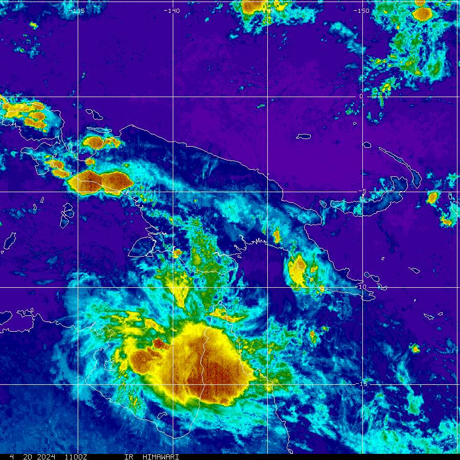
There are currently some nice radar images of Monica on the BOM Gove radar...
http://mirror.bom.gov.au/products/IDR092.shtml
http://mirror.bom.gov.au/products/IDR092.shtml
-
squid
- Posts: 1304
- Joined: Thu 16/06/2005 13:57
- Location: Caboolture,QLD
-
Storm Struck

- Posts: 5057
- Joined: Wed 17/11/2004 21:25
- Location: Belfast Christchurch
Some re thinking to call Monica a category 6 latest is she is at 875HPA and winds to more than 360kmh heading straight for Darwin its incrediably huge on sattelite and still getting bigger this would have to be the deepest strongest storm on earth if the facts and figures are true  .
.
Cheers
Jason.
Cheers
Jason.
Canterbury, home of good rugby and severe storms
-
Manukau heads obs
- Posts: 12305
- Joined: Mon 10/03/2003 16:30
- Location: West Coast Road, Manukau Peninsula, North Island
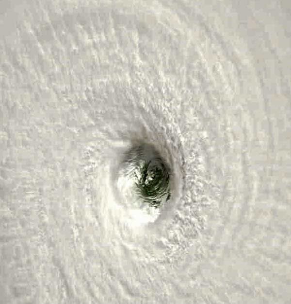
http://www.goes.noaa.gov/sohemi/SHGMSG.JPG
check that out!
you can see the shadow cast by the wall into the eye!!
check that out!
you can see the shadow cast by the wall into the eye!!
-
NZ Thunderstorm Soc
- Posts: 19109
- Joined: Wed 12/03/2003 22:08
- Location: Raukapuka Geraldine
Jasestrm wrote:Some re thinking to call Monica a category 6
Cheers
Jason.
They revised the Fujita scale for tornadoes. Maybe with Monica being a possible Cat6 with it's central pressure being so low, it may be a time to review Hurricane/TC/Typhoon powernesses.
There is no doubt, they are getting stronger.
JohnGaul
NZTS
-
Matt Townsend
- Banned
- Posts: 260
- Joined: Fri 27/01/2006 12:37
- Location: ballina/lismore
-
Manukau heads obs
- Posts: 12305
- Joined: Mon 10/03/2003 16:30
- Location: West Coast Road, Manukau Peninsula, North Island
looks to be moving WSW...towards Darwin...
good loop here:
http://www.bom.gov.au/products/IDE00900.loop.shtml
good loop here:
http://www.bom.gov.au/products/IDE00900.loop.shtml
-
Willoughby
- Site Admin
- Posts: 4443
- Joined: Sat 14/06/2003 16:18
- Location: Darwin, Australia: Storm city
-
jrj
- Posts: 462
- Joined: Tue 18/03/2003 18:00
- Location: Havelock North, New Zealand
CYCLONE MONICA MAY BE AUSTRALIA'S MOST SEVERE STORM
Small clusters of people remain on Northern Territory islands due to be hit by the most intense cyclone Australia's ever seen.
Cyclone Monica is a category 5 system and is expected to hit near the Coburg Peninsula later today.
Weather bureau spokesman Mike Bergin says Monica could be the most severe tropical cyclone seen anywhere along the Australian coastline.
Mr Bergin says that judgment is based on satellite images because there has been no "ground truth" yet.
"Whether or not the wind gusts are at 300 kilometres, or exactly what they are, is going to be difficult to assess," he said.
"But certainly we are in the right ball-park, which is an extremely destructive and a very dangerous system."
(ABC News)