Just on hurricane force. I guess crusaders force is about 80 knots and blues force is about 3 knotsNZ Metservice wrote: STORM WARNING A18 FOR HAURAKI GULF, FROM BREAM HEAD TO CAPE
COLVILLE :
Northerly 25 knots gusting 35 knots rising to 35 knots gusting 45
knots overnight and to 55 knots gusting 65 knots for a time Monday
morning. Becoming northwest 35 knots gusting 45 knots around midday
Monday then changing southwest 25 knots gusting 35 knots Monday
evening.
Monday 12th: Severe Gales, Snow and Storms
Forum rules
These topics are a read-only archive and may be subject to out-of-date information.
For today's weather discussion head to: New Zealand Weather & Climate
These topics are a read-only archive and may be subject to out-of-date information.
For today's weather discussion head to: New Zealand Weather & Climate
-
GraemeWi
- Posts: 1012
- Joined: Sun 30/03/2003 18:28
- Location: Hobsonville Point, Auckland
Auckland VHF warning is interesting:
-
gllitz

- Posts: 1335
- Joined: Wed 04/01/2006 11:45
- Location: Perth, Western Australia
GOOOO THE MIGHTY CRUSADERSGraemeWi wrote:Auckland VHF warning is interesting:
Just on hurricane force. I guess crusaders force is about 80 knots and blues force is about 3 knotsNZ Metservice wrote: STORM WARNING A18 FOR HAURAKI GULF, FROM BREAM HEAD TO CAPE
COLVILLE :
Northerly 25 knots gusting 35 knots rising to 35 knots gusting 45
knots overnight and to 55 knots gusting 65 knots for a time Monday
morning. Becoming northwest 35 knots gusting 45 knots around midday
Monday then changing southwest 25 knots gusting 35 knots Monday
evening.
-
Manukau heads obs
- Posts: 12305
- Joined: Mon 10/03/2003 16:30
- Location: West Coast Road, Manukau Peninsula, North Island

-
Gary Roberts
- Posts: 2363
- Joined: Sun 18/01/2004 18:59
- Location: Omarama
-
GraemeWi
- Posts: 1012
- Joined: Sun 30/03/2003 18:28
- Location: Hobsonville Point, Auckland
I'd love to be there tomorrow, but will be at workManukau heads observer wrote:wow
you dont see 65 knots in the forecast very often
gonna be a great high wind chase out this way tomorrow....!!
no takers yet though, so it will be just be me at this stage...
i will take some video footage....on the camera for any interested people
-
Gary Roberts
- Posts: 2363
- Joined: Sun 18/01/2004 18:59
- Location: Omarama
-
RWood
- Posts: 3745
- Joined: Sat 24/01/2004 16:56
- Location: Wellington
-
Willoughby

- Site Admin
- Posts: 4443
- Joined: Sat 14/06/2003 16:18
- Location: Darwin, Australia: Storm city
-
Flutterbye
- Posts: 1268
- Joined: Fri 16/12/2005 22:14
- Location: Southland
-
03Stormchaser

- Moderator
- Posts: 4433
- Joined: Tue 09/12/2003 12:11
- Location: Prebbleton
Has anyone ever seen so many warnings at metservice??
NZ Largest Storm Chasing Facebook Pagehttp://www.facebook.com/nzstormchasers
NZ Largest Storm Chase Community https://www.facebook.com/groups/NZStormchasersGroup
NZ Stormchasers TV https://www.youtube.com/@NZStormchasers
NZ Largest Storm Chase Community https://www.facebook.com/groups/NZStormchasersGroup
NZ Stormchasers TV https://www.youtube.com/@NZStormchasers
-
Willoughby
- Site Admin
- Posts: 4443
- Joined: Sat 14/06/2003 16:18
- Location: Darwin, Australia: Storm city
Sorry, flutterbye.. a mid to upper trough is surging through.. humid northerly air undercutting or hitting the cold sub-antarctic air. Tony can you confirm this? It really looks amazing..
Cb splitting and diverting towards Auckland by the look of the latest satellite image.
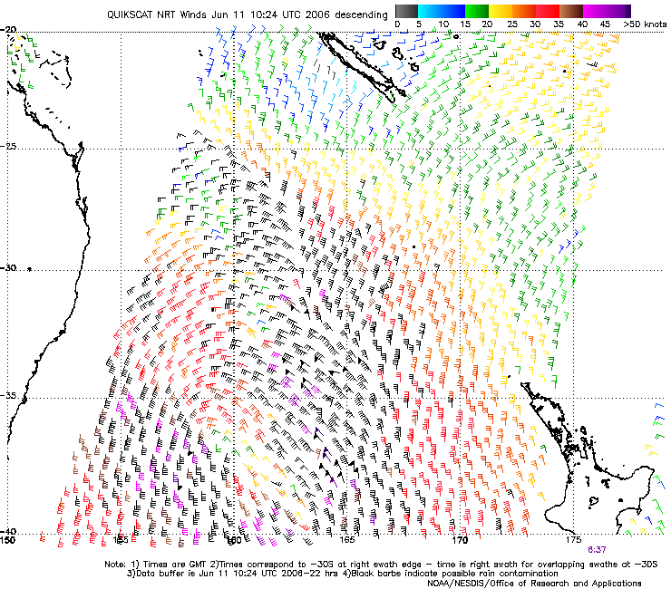
Quikscat satellite shows quite a strong frontal boundary embedded at the moment.. winds gusting to 60 knots by the looks!
Cb splitting and diverting towards Auckland by the look of the latest satellite image.
Quikscat satellite shows quite a strong frontal boundary embedded at the moment.. winds gusting to 60 knots by the looks!
-
KiwiWeather

- Posts: 403
- Joined: Wed 01/02/2006 15:58
- Location: South Auckland - NZ
Amazing to see all these warnings.
But has any Aucklander looked at the moon tonight?
I am totally gobsmacked at the beauty of it this evening. Believe me, I have tried to capture it on film but I don't have the knowledge nor the equipment to do it.
There is this enormous perfect ring around the moon, which has it in a huge circle of clear sky, amid fog elsewhere. It is a sight to behold. I have only seen this once before in the UK, but the clarity here is breath taking.
I did notice that earlier on, it had a beautiful bright blue ring around the immediate perimetre - which I presume is because of ice crystals?
Go and and have a gander, you won't be disappointed.
-
squid
- Posts: 1304
- Joined: Thu 16/06/2005 13:57
- Location: Caboolture,QLD
-
Willoughby
- Site Admin
- Posts: 4443
- Joined: Sat 14/06/2003 16:18
- Location: Darwin, Australia: Storm city
-
squid
- Posts: 1304
- Joined: Thu 16/06/2005 13:57
- Location: Caboolture,QLD
HEAVY SNOW WARNING
AREA/S AFFECTED: CANTERBURY SOUTH OF BANKS PENINSULA
FORECAST:
In the 9 hours from 10pm Sunday to 7am Monday, expect up to 15cm of snow to
accumulate down to 300 metres, with lighter falls down to 200 metres.
well there is a heavy snow warning for ya
wow warnings out for eveything wind,rain ,snow
when was the last time something this intense threatened or crossed nz??
-
squid
- Posts: 1304
- Joined: Thu 16/06/2005 13:57
- Location: Caboolture,QLD
-
Willoughby
- Site Admin
- Posts: 4443
- Joined: Sat 14/06/2003 16:18
- Location: Darwin, Australia: Storm city
-
Willoughby
- Site Admin
- Posts: 4443
- Joined: Sat 14/06/2003 16:18
- Location: Darwin, Australia: Storm city
Reports of heavy snow out of Timaru and Central Otago.. Gary looks like your station is reporting it? 
125mm of snow in Ashburton, 50mm in Timaru, 150mm in places.. reports of power outages out the back of Timaru
Waimate to Ashburton worst effected.. local radio stations out.
Edit, MetService just upgraded the Chch urban forecast to "Snow easing to few showers"
You lucky sods!
125mm of snow in Ashburton, 50mm in Timaru, 150mm in places.. reports of power outages out the back of Timaru
Waimate to Ashburton worst effected.. local radio stations out.
Edit, MetService just upgraded the Chch urban forecast to "Snow easing to few showers"
You lucky sods!
-
Manukau heads obs
- Posts: 12305
- Joined: Mon 10/03/2003 16:30
- Location: West Coast Road, Manukau Peninsula, North Island
6:20 am here
wind increasing here now, NNE, 33 knots gusting too
yes, I saw the moon last night and the halo
latest sat image shows the low center heading for cook straight area
and a strong front has developed to the sout of the low, but the front to the east of the low is unorganised at this stage, rain radar shows only scattered heavy showers along the front....
but it will probably get more organised as the day progresses
temperature climbing here now, nearly 15oC here now
-
Storm Struck

- Posts: 5057
- Joined: Wed 17/11/2004 21:25
- Location: Belfast Christchurch
NEVER Seen anything like it outside  massive drops of rain or large sleet flooded from back to front property streets flooded ekkk watch the rivers at high tide especially the avon.
It's been heavy rain since 3:30am and still going.
EDIT.. Heavy snow falling in Rangiora,Oxford,Timaru,Cashmere hills this is interesting.
Cheers
Jason.
It's been heavy rain since 3:30am and still going.
EDIT.. Heavy snow falling in Rangiora,Oxford,Timaru,Cashmere hills this is interesting.
Cheers
Jason.
Last edited by Storm Struck on Mon 12/06/2006 06:39, edited 1 time in total.
Canterbury, home of good rugby and severe storms
-
Skywatcher
- Posts: 1249
- Joined: Fri 21/02/2003 13:11
- Location: Templeton, Christchurch
-
Gary Roberts
- Posts: 2363
- Joined: Sun 18/01/2004 18:59
- Location: Omarama
Gettin' Fat offa Ma' Own Words!
I awoke to find 15 cm of snow covering everything and more falling steadily! WOOHOO!Steven Graham wrote:After a night of heavy rain then sleet, it's finally gone quiet here because it turned to snow and is already starting to settle
-
Cameo1
- Posts: 417
- Joined: Mon 24/04/2006 19:32
- Location: New Lynn West, Auckland