Storms & gales Eastern SI, Oct 24th
Forum rules
These topics are a read-only archive and may be subject to out-of-date information.
For today's weather discussion head to: New Zealand Weather & Climate
These topics are a read-only archive and may be subject to out-of-date information.
For today's weather discussion head to: New Zealand Weather & Climate
-
gopolks
- Posts: 706
- Joined: Thu 22/03/2007 16:48
- Location: Canterbury
-
gopolks
- Posts: 706
- Joined: Thu 22/03/2007 16:48
- Location: Canterbury
-
Andrew Massie
- Posts: 1032
- Joined: Fri 10/03/2006 14:03
Re: Storms & massive winds hitting E'n SI, Oct 24th
Just been out chasing.. It's still going on out there, 2 cells passed directly over me heading North, got plenty video, photos, will post tomorrow (camera issue). 12mm Hail and lightning every 20 odd seconds. A third cell inland, will prob be over Jase in Kaiapoi now...
AHhhhhhh.. That'll shut me up for a while!
My station info here: http://www.wunderground.com/weatherstat ... ICANTERB16
AHhhhhhh.. That'll shut me up for a while!
My station info here: http://www.wunderground.com/weatherstat ... ICANTERB16
-
dogmelon
- Posts: 451
- Joined: Wed 22/09/2004 13:24
- Location: Chch.
Re: Storms & massive winds hitting E'n SI, Oct 24th
This thunderstorm just proves that you can get thunderstorms on a sw change when there is a warm w/nw wind blowing before it.
-
NZ Thunderstorm Soc
- Posts: 19101
- Joined: Wed 12/03/2003 22:08
- Location: Raukapuka Geraldine
Re: Massive winds hitting chch
Thunderstorm moving over Christchurch.
It stalled my internet
This was a bit of a surprise? even for me
JohnGaul
NZTS
It stalled my internet
This was a bit of a surprise? even for me
JohnGaul
NZTS
JohnGaul
NZThS
NZThS
-
David

- Posts: 7651
- Joined: Sat 18/08/2007 21:02
- Location: Howick, Auckland
Re: Storms & massive winds hitting E'n SI, Oct 24th
Chch airport winds at 8pm S26kts gusting to 41kts (76km/h)
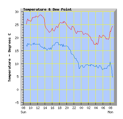
Sounds like some pretty well developed cells down there - hopefully when the action finishes us up here can at least see some images to bring some cheer out of the boredom of our weather pattern for the next week.
A pretty sharp temperature decreases a drop of 9 degrees in some places
http://weather.northcott.co.nz/images/s ... hrtemp.png
Last edited by David on Wed 24/10/2007 20:24, edited 1 time in total.
-
Inny Binny
- Posts: 553
- Joined: Sat 01/09/2007 12:15
- Location: Prebbleton
Re: Storms & massive winds hitting E'n SI, Oct 24th
Well I was out just delivering my junk mail, small hail pelting down before really hurting too  saw plenty of lightning everywhere and very,very windy and cold too.
-
Andrew Massie
- Posts: 1032
- Joined: Fri 10/03/2006 14:03
Re: Storms & massive winds hitting E'n SI, Oct 24th
Well.. I have to say, I'm not that impressed with the tracker accuracy.. We need more SI ones, obviously.. <checks bank account> 
-
David
- Posts: 7651
- Joined: Sat 18/08/2007 21:02
- Location: Howick, Auckland
Re: Storms & massive winds hitting E'n SI, Oct 24th
Strange how MS never forecast a thunderstorm risk for Canterbury today.
Last edited by David on Wed 24/10/2007 22:15, edited 1 time in total.
-
Willoughby

- Site Admin
- Posts: 4441
- Joined: Sat 14/06/2003 16:18
- Location: Darwin, Australia: Storm city
Re: Storms & massive winds hitting E'n SI, Oct 24th
Here's where you need correlation, not another Chch one... a boltek based in Ashburton/Kaikoura would track storms a lot better over the Canty Plains than it is so currently.Andrew Massie wrote:Well.. I have to say, I'm not that impressed with the tracker accuracy.. We need more SI ones, obviously.. <checks bank account>
-
mikestormchaser
- Posts: 2794
- Joined: Sat 03/06/2006 20:11
- Location: Rolleston, Canterbury
Re: Storms & gales Eastern SI, Oct 24th
yes got very windy, thunder and lightning, with sporadic rain and also some hail, id say 10mm in diameter size. first storm for the season, so heres to it! wasn't just one storm this evening either!
Mike
Stormchasers.co.nz
Stormchasers.co.nz
-
NZstorm

- Posts: 11333
- Joined: Mon 10/03/2003 19:38
- Location: Grey Lynn, Auckland
Re: Storms & massive winds hitting E'n SI, Oct 24th
That storm developed under the radar. No one forecast it! But looking at todays model run the 500mb -30C air gets right up the Canterbury coast.
-
Storm Struck

- Posts: 5056
- Joined: Wed 17/11/2004 21:25
- Location: Belfast Christchurch
Re: Storms & massive winds hitting E'n SI, Oct 24th
WOW first storm I watched over CHCH moving out into Pegasus some absoulute cracker CG's coming down.
I tried getting some lightning pics from that one not sure how well they came out just yet.
Just as i was beginning to give up and think that we wernt going to get any storms....
A nice flash from a completly different cell light up the sky in front of me to the W-SW then BOOOOM.
Out comes the video camera and a CG comes down towards the SW, and one of the most hairaising closest Bolts ive ever seen light up the sky kind of sprited across then hit the ground .
Not sure on the quality of the video as the council decided to turn the street lights on early because of the storm and I didnt realise so there was abit of out of focus.
Still you can hear the thunder and me cursing .
Will post pictures later, and here is why thunderstorms went through this evening in a W-SW flow.
See how the cold front has shunted the ridging of the NW flow inland, which has therefore given time for the trough inbehnind it to develop thunderstorms.
Going to keep this map for the next time we have a simular situation and compare.
Ye harr bring on storm season.
Cheers
Jason.
I tried getting some lightning pics from that one not sure how well they came out just yet.
Just as i was beginning to give up and think that we wernt going to get any storms....
A nice flash from a completly different cell light up the sky in front of me to the W-SW then BOOOOM.
Out comes the video camera and a CG comes down towards the SW, and one of the most hairaising closest Bolts ive ever seen light up the sky kind of sprited across then hit the ground
Not sure on the quality of the video as the council decided to turn the street lights on early because of the storm and I didnt realise so there was abit of out of focus.
Still you can hear the thunder and me cursing
Will post pictures later, and here is why thunderstorms went through this evening in a W-SW flow.
See how the cold front has shunted the ridging of the NW flow inland, which has therefore given time for the trough inbehnind it to develop thunderstorms.
Going to keep this map for the next time we have a simular situation and compare.
Ye harr bring on storm season.
Cheers
Jason.
You do not have the required permissions to view the files attached to this post.
Canterbury, home of good rugby and severe storms
-
TonyT

- Moderator
- Posts: 3006
- Joined: Thu 08/05/2003 11:09
- Location: Amberley, North Canterbury
Re: Storms & massive winds hitting E'n SI, Oct 24th
Actually, it probably developed almost over the top of the radar (at Rakaia)!NZstorm wrote:That storm developed under the radar. No one forecast it! But looking at todays model run the 500mb -30C air gets right up the Canterbury coast.
We did have "SW change in the evening with a few showers" in our forecast, shame we left out the word "thundery".
A very strong SW change here, no hail or thunder, but winds just as gale force from the S (not SW) for 10-15 mins as they were from the NW during the afternoon. Reminiscent of some of the SW changes I can remember from the 1980s. Reports of thunder and hail in Rangiora earlier, the power was off there for around 20 minutes, and a comment that there was a "cloudburst with torrential rain" just before the power went off.
Interesting to piece together some of the reports - seems like a (at least partial) meso-cyclonic system generated over the Plains late afternoon - the skies were very clear all through the time of the mid afternoon gales, so there was some ground heating, plus there was probably some fairly major vorticity on the southern side of the jet which brought the gales - line that lot up with a cold change moving up from Otago, the cold upper air Steven has mentioned, and bang, off it goes. A lot of our best SW changes come from this sort of scenario - unstable strong westerly flow for several days prior, then a combination of upper jet and weak cold front, which seems to allow storm development on its leading edge as it propagates northwards, especially if its late afternoon across the Plains. These weak, ill-defined fronts are often more "productive" than the stronger, more clearly defined ones.
-
TonyT
- Moderator
- Posts: 3006
- Joined: Thu 08/05/2003 11:09
- Location: Amberley, North Canterbury
Re: Storms & massive winds hitting E'n SI, Oct 24th
Evidence of a well defined squall line right across the Plains on this 7pm radar scan with hail embedded in it. See how it curves back into the more complex area of heavy showers about to hit the Peninsula.
You do not have the required permissions to view the files attached to this post.
-
NZstorm
- Posts: 11333
- Joined: Mon 10/03/2003 19:38
- Location: Grey Lynn, Auckland
Re: Storms & massive winds hitting E'n SI, Oct 24th
I have found once the 500mb temps get -30C or colder Thunderstorms can form more easily if there is good forcing as the surface dp only needs to be about 8C or 7C for deep convection.
-
gllitz

- Posts: 1335
- Joined: Wed 04/01/2006 11:45
- Location: Perth, Western Australia
Re: Storms & massive winds hitting E'n SI, Oct 24th
The GFS models from weatherzone were showing a LFTX of around 0 - -2 for the Canty coast near BP from last night's/today's runs...
You do not have the required permissions to view the files attached to this post.
"Saru mo ki kara ochiru"
-
NZ Thunderstorm Soc
- Posts: 19101
- Joined: Wed 12/03/2003 22:08
- Location: Raukapuka Geraldine
Re: Storms & massive winds hitting E'n SI, Oct 24th
I think Paul has definately lost an earning of a NZTS T-shirt on this one? 
JohnGaul
NZTS
JohnGaul
NZTS
JohnGaul
NZThS
NZThS
-
Willoughby
- Site Admin
- Posts: 4441
- Joined: Sat 14/06/2003 16:18
- Location: Darwin, Australia: Storm city
Re: Storms & gales Eastern SI, Oct 24th
Leeward forcing coming onto the Cook Strait is leading to a few nice storms nearing Ngawi/Cape Palliser now!
-
Andrew Massie
- Posts: 1032
- Joined: Fri 10/03/2006 14:03
Re: Storms & massive winds hitting E'n SI, Oct 24th
There's a weather station in Ash Vegas.. Maybe we should coerce "In the interest of science"!Foggy wrote:Here's where you need correlation, not another Chch one... a boltek based in Ashburton/Kaikoura would track storms a lot better over the Canty Plains than it is so currently.Andrew Massie wrote:Well.. I have to say, I'm not that impressed with the tracker accuracy.. We need more SI ones, obviously.. <checks bank account>
I can't afford anyway...!
-
mikestormchaser
- Posts: 2794
- Joined: Sat 03/06/2006 20:11
- Location: Rolleston, Canterbury
Re: Storms & gales Eastern SI, Oct 24th
wooo what a night! unexpected thunderstorms come in! well... i got two nice photos of the roll cloud that came up before the actual big storms, some nice lightning and some very strong winds with the change, about time we got something. wahooooooo oh and thanks for the txts and updates as those cells were moving in Andrew massie
Last edited by mikestormchaser on Wed 24/10/2007 23:34, edited 1 time in total.
Mike
Stormchasers.co.nz
Stormchasers.co.nz
-
03Stormchaser

- Moderator
- Posts: 4433
- Joined: Tue 09/12/2003 12:11
- Location: Prebbleton
Re: Storms & gales Eastern SI, Oct 24th
Saw a few cg's, hail probably up to 10mm.
Nice little clip here my mate took of the lightning. http://bebo.com/watch/4917644571
Nice little clip here my mate took of the lightning. http://bebo.com/watch/4917644571
NZ Largest Storm Chasing Facebook Pagehttp://www.facebook.com/nzstormchasers
NZ Largest Storm Chase Community https://www.facebook.com/groups/NZStormchasersGroup
NZ Stormchasers TV https://www.youtube.com/@NZStormchasers
NZ Largest Storm Chase Community https://www.facebook.com/groups/NZStormchasersGroup
NZ Stormchasers TV https://www.youtube.com/@NZStormchasers
-
David
- Posts: 7651
- Joined: Sat 18/08/2007 21:02
- Location: Howick, Auckland
Re: Storms & gales Eastern SI, Oct 24th
Well I would watch it, but there's nothing there when the page loads except text.03Stormchaser wrote:Nice little clip here my mate took of the lightning
-
Michael

- Posts: 7210
- Joined: Thu 27/03/2003 12:04
- Location: Rainy Manurewa, Auckland - "City of Gales"
Re: Storms & gales Eastern SI, Oct 24th
You may need adobe flashplayer v9
David wrote:Well I would watch it, but there's nothing there when the page loads except text.03Stormchaser wrote:Nice little clip here my mate took of the lightning
-
spwill
- Posts: 10196
- Joined: Sun 29/06/2003 22:39
- Location: Mt Eden Auckland